File:Amery Ice Shelf.jpg

Изворна податотека (720 × 720 пиксели, големина: 160 КБ, MIME-тип: image/jpeg)
Описи
Описи
Опис[уреди]
| Опис |
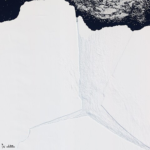
English: Several glaciers in East Antarctica, including the Lambert Glacier, share the same route to the ocean through the Amery Ice Shelf. Although comprising just a tiny portion of the Antarctic coastline, this ice shelf drains roughly 16 percent of the East Antarctic Ice Sheet. The Amery deposits ice into the ocean through the natural, cyclical process of iceberg calving—a process that can take decades to complete.
The Advanced Land Imager (ALI) on NASA’s Earth Observing-1 (EO-1) satellite captured this natural-color image on January 27, 2012. It shows a portion of the Amery Ice Shelf, where three giant cracks, or rifts, meet. The largest rift runs in the same direction as the ice flow, and widens toward the edge of the ice shelf (image center). Smaller rifts extend toward the east and west, and the tip of the western rift narrows and curves significantly (image lower left). These rifts lie along the western edge of a feature glaciologists have nicknamed Amery’s “loose tooth.” The tooth is a giant tabular iceberg that has been gradually loosening for more than a decade. The overall cycle of iceberg calving on the Amery Ice Shelf is slow, with the last major calving event occurring in the early 1960s. At that time, Amery released an ice island measuring roughly 140 by 70 kilometers. Although slow calving of icebergs has been the norm for the ice shelf, a rapid retreat is possible. Although much smaller than Antarctica’s largest ice shelves—the Ross and Filchner-Ronne—the Amery lies several degrees closer to the Equator. It also has some of the same traits as ice shelves that have retreated on the Antarctic Peninsula, such as extensive crevasses (cracks) and annual surface melt streams |
| Датум | |
| Извор | http://earthobservatory.nasa.gov/IOTD/view.php?id=77132 |
| Автор | NASA Earth Observatory |
Лиценцирање[уреди]
| Оваа податотека е во јавна сопственост бидејќи нејзин создавач е НАСА. Правилата за авторски права на НАСА велат: „Материјалот на НАСА не е заштитен со авторски права освен ако не е поинаку нагласено“. (Правилата за авторски дела на НАСА или правила за користење на слики од Лабораторијата за реактивен погон (JPL)). | ||
 |
Предупредувања:
|
Историја на податотеката
Стиснете на датум/време за да ја видите податотеката како изгледала тогаш.
| Датум/време | Минијатура | Димензии | Корисник | Коментар | |
|---|---|---|---|---|---|
| тековна | 13:18, 24 февруари 2012 | | 720 × 720 (160 КБ) | 4ing (разговор | придонеси) |
Не можете да презапишете врз податотекава.
Употреба на податотеката
Податотекава се користи во следниве 2 страници:
- File:Amery ali 2012027.jpg (пренасочување)
- Category:Amery Ice Shelf
Глобална употреба на податотеката
Оваа податотека ја користат и следниве викија:
- Употреба на de.wikipedia.org
- Употреба на en.wikipedia.org
- Употреба на fr.wikipedia.org
- Употреба на he.wikipedia.org
- Употреба на it.wikipedia.org
- Употреба на ka.wikipedia.org
- Употреба на lt.wikipedia.org
- Употреба на mk.wikipedia.org
- Употреба на nn.wikipedia.org
- Употреба на pl.wikipedia.org
- Употреба на ru.wikipedia.org
- Употреба на sv.wikipedia.org
- Употреба на uk.wikipedia.org
- Употреба на www.wikidata.org
- Употреба на zh.wikipedia.org