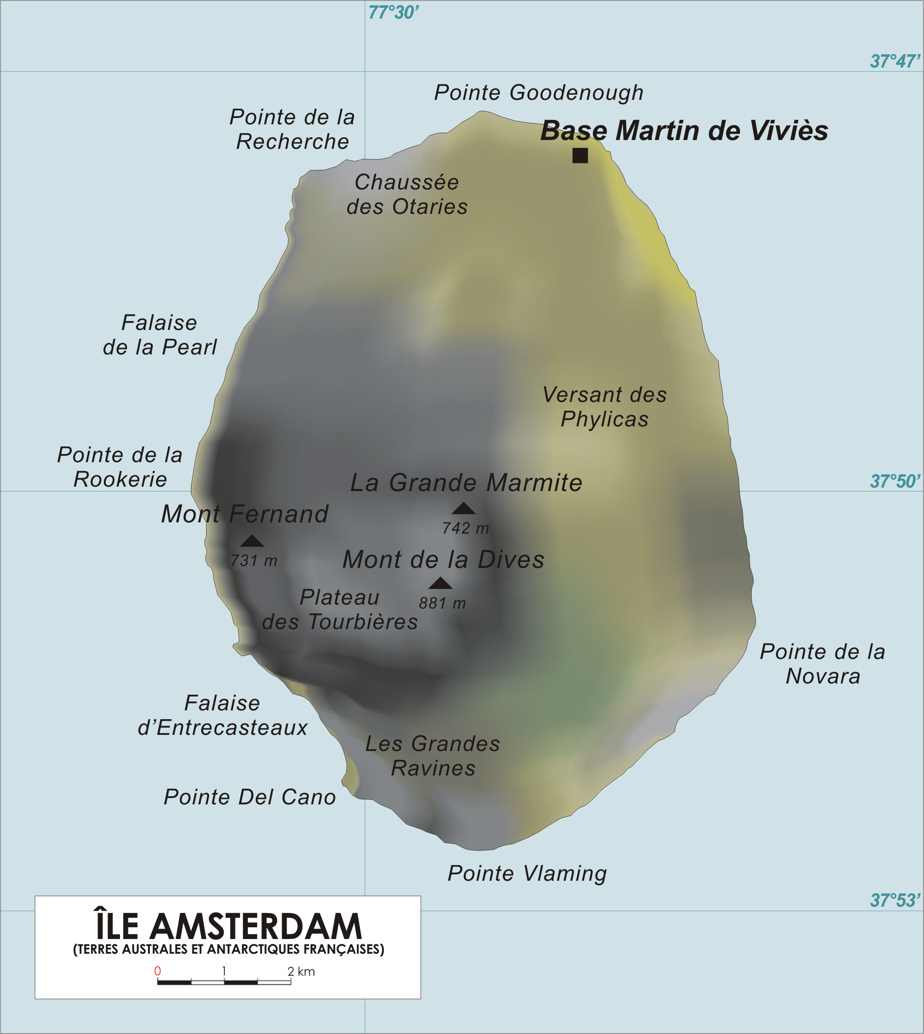
File:AmsterdamIsl Map.png
跳至導覽
跳至搜尋
預覽大小:536 × 600 像素。 其他解析度:214 × 240 像素 | 429 × 480 像素 | 686 × 768 像素 | 915 × 1,024 像素 | 1,887 × 2,112 像素。
原始檔案 (1,887 × 2,112 像素,檔案大小:732 KB,MIME 類型:image/png)
說明
說明
添加單行說明來描述出檔案所代表的內容
檔案歷史
點選日期/時間以檢視該時間的檔案版本。
| 日期/時間 | 縮圖 | 尺寸 | 用戶 | 備註 | |
|---|---|---|---|---|---|
| 目前 | 2013年1月28日 (一) 17:43 | | 1,887 × 2,112(732 KB) | Olli Niemitalo(對話 | 貢獻) | Correct scale bar length |
| 2006年4月27日 (四) 14:05 |  | 1,887 × 2,112(1.05 MB) | Varp~commonswiki(對話 | 貢獻) | ||
| 2006年4月26日 (三) 13:50 |  | 1,887 × 1,965(1.01 MB) | Varp~commonswiki(對話 | 貢獻) | *Map of Amsterdam Island, French Southern and Antarctic Territories *drawn by varp |
無法覆蓋此檔案。
檔案用途
下列3個頁面有用到此檔案:
全域檔案使用狀況
以下其他 wiki 使用了這個檔案:
- af.wikipedia.org 的使用狀況
- ar.wikipedia.org 的使用狀況
- az.wikipedia.org 的使用狀況
- bg.wikipedia.org 的使用狀況
- br.wikipedia.org 的使用狀況
- ca.wikipedia.org 的使用狀況
- ceb.wikipedia.org 的使用狀況
- cs.wikipedia.org 的使用狀況
- cv.wikipedia.org 的使用狀況
- da.wikipedia.org 的使用狀況
- de.wikipedia.org 的使用狀況
- el.wikipedia.org 的使用狀況
- en.wikipedia.org 的使用狀況
- en.wikivoyage.org 的使用狀況
- eo.wikipedia.org 的使用狀況
- es.wikipedia.org 的使用狀況
- fi.wikipedia.org 的使用狀況
- fr.wikipedia.org 的使用狀況
- fr.wiktionary.org 的使用狀況
- fy.wikipedia.org 的使用狀況
- hr.wikipedia.org 的使用狀況
- hu.wikipedia.org 的使用狀況
- id.wikipedia.org 的使用狀況
- it.wikipedia.org 的使用狀況
- ja.wikipedia.org 的使用狀況
- ka.wikipedia.org 的使用狀況
- lij.wikipedia.org 的使用狀況
- lld.wikipedia.org 的使用狀況
- lt.wikipedia.org 的使用狀況
- lv.wikipedia.org 的使用狀況
- mk.wikipedia.org 的使用狀況
- nds-nl.wikipedia.org 的使用狀況
- nds.wikipedia.org 的使用狀況
檢視此檔案的更多全域使用狀況。