File:Ancient Egypt map-la.svg
Aller à la navigation
Aller à la recherche

Taille de cet aperçu PNG pour ce fichier SVG : 293 × 598 pixels. Autres résolutions : 117 × 240 pixels | 235 × 480 pixels | 376 × 768 pixels | 501 × 1 024 pixels | 1 003 × 2 048 pixels | 1 577 × 3 219 pixels.
Fichier d’origine (Fichier SVG, nominalement de 1 577 × 3 219 pixels, taille : 1,57 Mio)
Légendes
Légendes
Ajoutez en une ligne la description de ce que représente ce fichier
Description[modifier]
Cette image vectorielle SVG non W3C-spécifiée a été créée avec Inkscape .
| Description |
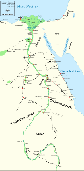
English: Map of Ancient Egypt, showing the Nile up to the fifth cataract, and major cities and sites of the Dynastic period (c. 3150 BC to 30 BC). Jerusalem is shown as reference cities. |
| Date | |
| Source |
Own work. See #References for references used creating the map. |
| Auteur | Gigillo83 |
| Autres versions |
[]
|


|
Ce fichier SVG contient du texte encapsulé pouvant facilement être traduit dans votre langue en utilisant n'importe quel éditeur de fichier SVG ou de texte, ou par l'outil de traduction de fichiers SVG. Pour plus d'informations, voir : A propos de la traduction des fichiers SVG. |
Conditions d’utilisation[modifier]
Moi, en tant que détenteur des droits d’auteur sur cette œuvre, je la publie sous les licences suivantes :

|
Vous avez la permission de copier, distribuer et modifier ce document selon les termes de la GNU Free Documentation License version 1.2 ou toute version ultérieure publiée par la Free Software Foundation, sans sections inaltérables, sans texte de première page de couverture et sans texte de dernière page de couverture. Un exemplaire de la licence est inclus dans la section intitulée GNU Free Documentation License. |
This file is licensed under the Creative Commons Attribution-Share Alike Attribution-Share Alike 4.0 International, 3.0 Unported, 2.5 Generic, 2.0 Generic and 1.0 Generic license.
- Vous êtes libre :
- de partager – de copier, distribuer et transmettre cette œuvre
- d’adapter – de modifier cette œuvre
- Sous les conditions suivantes :
- paternité – Vous devez donner les informations appropriées concernant l'auteur, fournir un lien vers la licence et indiquer si des modifications ont été faites. Vous pouvez faire cela par tout moyen raisonnable, mais en aucune façon suggérant que l’auteur vous soutient ou approuve l’utilisation que vous en faites.
- partage à l’identique – Si vous modifiez, transformez, ou vous basez sur cette œuvre, vous devez distribuer votre contribution sous la même licence ou une licence compatible avec celle de l’original.
Vous pouvez choisir l’une de ces licences.
References[modifier]
Resources used to create the map:
- Shaw, Ian , ed. (2003) The Oxford History of Ancient Egypt, Oxford University Press ISBN : 0-19-280293-3.
- Dr. Peter Der Manuelian , ed. (1998) Egypt: The World of the Pharaohs, Bonner Straße, Köln (Deutschland) : Könemann Verlagsgesellschaft mbH ISBN : 3-89508-913-3.
- Digital Egypt - maps. Retrieved on 2007-11-25.
- NASA PIA04957. Retrieved on 2007-11-25.
- NASA PIA02647. Retrieved on 2007-11-25.
- NASA PIA04965. Retrieved on 2007-11-25.
Reference coordinates:
- Sais 30°57′53″N, 30°46′6″E
- Buto 31°11′47″N, 30°44′41″E
- Alexandria 31°11′53″N 29°55′09″E
- Naukratis 30°54' N 30°35'E coordinates here
- Tanis 30°58′37″N, 31°52′48″E
- Avaris 30°47′N, 31°50′E
- Busiris 30°54′40″N, 31°14′40″E
Journal des téléversements d’origine[modifier]
The original description page is/was here. All following user names refer to Commons.
- 2009-01-29 13:21 Bibi Saint-Pol 1577×3219×0 (412000 bytes) (remove wrong text, adjust frame)
- 2009-01-29 12:47 Bibi Saint-Pol 1577×3219×0 (413000 bytes) (added frame)
- 2009-01-29 12:35 Bibi Saint-Pol 1577×3219×0 (412000 bytes) (harmonize colors with the standards + replace unsupported Arial fonts by DejaVu )
- 2008-02-11 06:55 Jeff Dahl 1577×3219×0 (391000 bytes) (sp fx)
- 2007-11-29 02:09 Jeff Dahl 1577×3219×0 (391000 bytes) (Rotate Mediterranean Sea label)
- 2007-11-27 23:32 Jeff Dahl 1577×3219×0 (391000 bytes) (Minor adjustments to Naukratis and Buto)
- 2007-11-27 18:59 Jeff Dahl 1577×3219×0 (391000 bytes) (Cairo and Jerusalem now with black dots/italics)
- 2007-11-23 00:04 Jeff Dahl 1577×3219×0 (391000 bytes) (fx scalebar)
- 2007-11-22 23:56 Jeff Dahl 1577×3219×0 (391000 bytes) ({{Information |Description=A map of ancient Egypt, made with Inkscape |Source=self-made |Date=11-22-07 |Author= Jeff Dahl |Permission= |other_versions={{DerivativeVersions|Ancient Egypt map-ru.svg}} }} )
Historique du fichier
Cliquer sur une date et heure pour voir le fichier tel qu'il était à ce moment-là.
| Date et heure | Vignette | Dimensions | Utilisateur | Commentaire | |
|---|---|---|---|---|---|
| actuel | 1 mars 2010 à 21:54 | | 1 577 × 3 219 (1,57 Mio) | Gigillo83 (d | contributions) | Fix write |
| 20 janvier 2010 à 15:26 |  | 1 577 × 3 219 (446 kio) | Gigillo83 (d | contributions) | Aggiungo strada | |
| 20 janvier 2010 à 14:59 |  | 1 577 × 3 219 (444 kio) | Gigillo83 (d | contributions) | Aggiunti nomi e corretti luoghi | |
| 17 janvier 2010 à 12:37 |  | 1 577 × 3 219 (414 kio) | Gigillo83 (d | contributions) | Aggiunte vie e impianti militari | |
| 6 janvier 2010 à 11:53 |  | 1 577 × 3 219 (407 kio) | Gigillo83 (d | contributions) | == {{int:filedesc}} == {{inkscape}} {{Information |Description= {{en|Map of Ancient Egypt, showing the Nile up to the fifth cataract, and major cities and sites of the Dynastic period (c. 3150 BC to 30 BC). Jerusalem is shown as reference cities.}} |Sourc |
Vous ne pouvez pas remplacer ce fichier.
Utilisations locales du fichier
Les 28 pages suivantes utilisent ce fichier :
- File:Ancient Egypt map-af.svg
- File:Ancient Egypt map-ar.png
- File:Ancient Egypt map-de.svg
- File:Ancient Egypt map-el.svg
- File:Ancient Egypt map-en.svg
- File:Ancient Egypt map-es.svg
- File:Ancient Egypt map-fr.svg
- File:Ancient Egypt map-hiero.svg
- File:Ancient Egypt map-it.svg
- File:Ancient Egypt map-la.png
- File:Ancient Egypt map-la.svg
- File:Ancient Egypt map-lat.svg (redirection de fichier)
- File:Ancient Egypt map-mk.svg
- File:Ancient Egypt map-nl.svg
- File:Ancient Egypt map-no.svg
- File:Ancient Egypt map-pl.svg
- File:Ancient Egypt map-pt.svg
- File:Ancient Egypt map-ru.svg
- File:Ancient Egypt map-sk.svg
- File:Ancient Egypt map-sr.svg
- File:Ancient Egypt map-vi.svg
- File:Ancient Egypt map-zh-hans.svg
- File:Antik Mısır haritası.png
- File:Antzinako Egipto.svg
- File:Mapo de antikva Egiptio.jpg
- File:Mapo de antikva Egiptio - centro.jpg
- File:Muistne Egiptus.png
- Template:Other versions/Ancient Egypt map
Utilisations du fichier sur d’autres wikis
Les autres wikis suivants utilisent ce fichier :
- Utilisation sur bg.wikipedia.org
- Utilisation sur cv.wikipedia.org
- Utilisation sur el.wikipedia.org
- Utilisation sur en.wikipedia.org
- Utilisation sur es.wikipedia.org
- Utilisation sur fr.wikipedia.org
- Utilisation sur he.wikipedia.org
- Utilisation sur it.wikipedia.org
- Limes (storia romana)
- Egitto (provincia romana)
- Prefetto d'Egitto
- Dodecascheno
- Augusto
- Campagne augustee lungo il fronte africano ed arabico
- Limes africano
- Progetto:Laboratorio grafico/Immagini da migliorare/Archivio risolte/39
- Via Hadriana
- Classis Alexandrina
- Politica estera di Augusto
- Utente:Barjimoa/SandboxP
- Utilisation sur la.wikipedia.org
- Utilisation sur mk.wikipedia.org
- Utilisation sur nl.wikipedia.org
- Utilisation sur pl.wikipedia.org
- Utilisation sur ru.wikipedia.org
- Utilisation sur uk.wikipedia.org
- Utilisation sur www.wikidata.org