File:Ancient peloponnese-it.svg
Jump to navigation
Jump to search

Size of this PNG preview of this SVG file: 583 × 599 pixels. Other resolutions: 233 × 240 pixels | 467 × 480 pixels | 747 × 768 pixels | 996 × 1,024 pixels | 1,992 × 2,048 pixels | 778 × 800 pixels.
Original file (SVG file, nominally 778 × 800 pixels, file size: 84 KB)
Captions
Captions
Add a one-line explanation of what this file represents
Summary
[edit]| Description |
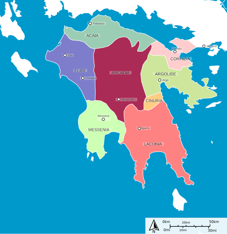
English: Ancient peloponnese map Italiano: Mappa dell'antico Peloponneso |
| Date | (UTC) |
| Source |
This file was derived from: Ancient peloponnese.svg:  |
| Author |
|
| Other versions |
[]
|


| This is a retouched picture, which means that it has been digitally altered from its original version. Modifications: Italian translation. The original can be viewed here: Ancient peloponnese.svg:
|
Licensing
[edit]
I, the copyright holder of this work, hereby publish it under the following licenses:
This file is licensed under the Creative Commons Attribution-Share Alike 3.0 Unported license.
- You are free:
- to share – to copy, distribute and transmit the work
- to remix – to adapt the work
- Under the following conditions:
- attribution – You must give appropriate credit, provide a link to the license, and indicate if changes were made. You may do so in any reasonable manner, but not in any way that suggests the licensor endorses you or your use.
- share alike – If you remix, transform, or build upon the material, you must distribute your contributions under the same or compatible license as the original.

|
Permission is granted to copy, distribute and/or modify this document under the terms of the GNU Free Documentation License, Version 1.2 or any later version published by the Free Software Foundation; with no Invariant Sections, no Front-Cover Texts, and no Back-Cover Texts. A copy of the license is included in the section entitled GNU Free Documentation License. |
You may select the license of your choice.
Original upload log
[edit]
This image is a derivative work of the following images:
- File:Ancient_peloponnese.svg licensed with Cc-by-sa-3.0, GFDL
- 2012-07-25T23:26:33Z Jkan997 778x800 (73432 Bytes) Added some cities
- 2012-07-25T23:19:25Z Jkan997 778x800 (71445 Bytes) {{Information |Description ={{en|1=Ancient peloponnese }} |Source = http://sharemap.org/public/Ancient_peloponnese Geospatial data sources: *Open Street Map Data (CC-SA-BY) - http://wiki.openstreetmap.org/wiki/OpenStreetMap_
File history
Click on a date/time to view the file as it appeared at that time.
| Date/Time | Thumbnail | Dimensions | User | Comment | |
|---|---|---|---|---|---|
| current | 10:40, 30 October 2013 | | 778 × 800 (84 KB) | Fulvio314 (talk | contribs) | + Cinuria |
| 10:07, 30 October 2013 |  | 778 × 800 (83 KB) | Fulvio314 (talk | contribs) | {{Information |Description={{en|1=Ancient peloponnese map}} {{it|1=Mappa dell'antico Peloponneso}} |Source={{Derived from|Ancient_peloponnese.svg|display=50}} |Date=2013-10-30 10:04 (UTC) |Author=*File:Ancient_peloponnese.svg: User:Jkan997 *deriv... |
You cannot overwrite this file.
File usage on Commons
The following 7 pages use this file:
File usage on other wikis
The following other wikis use this file:
- Usage on it.wikipedia.org