File:Andorra topographic map-ca.svg

元のファイル (SVG ファイル、1,625 × 1,300 ピクセル、ファイルサイズ: 1.58メガバイト)
キャプション
キャプション
| カメラの位置 | | 以下のサービスでこの位置を確認する: オープンストリートマップ |
|---|
| 解説 |
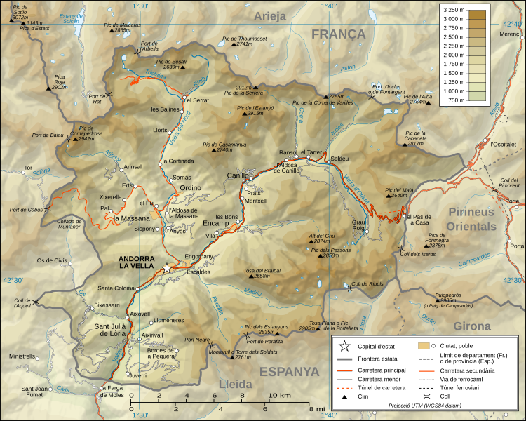
Català: Mapa topogràfic d'Andorra en versió en català English: Topographic map in Catalan of Andorra Français : Carte topographique en catalan de l'Andorre |
| 日付 | (UTC) |
| 原典 |
Català: Traducció de Andorra_topographic_map-fr.svg
L'original té les dades topogràfiques de la Missió NASA Shuttle Radar Topography (SRTM3 v.2) (domini públic) editat amb 3DEM i dlgv32 Pro i vectoritzat amb l'Inkscape; projecció UTM; WGS84 datum; relleu ombrejat (imatge composta de posicions lluminoses de NO, O i N). Referència per les dades addicionals:
Escala aproximada de les dades topogràfiques: 1:400.000 (precisió: uns 100 m); Nota: El relleu ombrejat és una imatge rastrejada immersa en el fitxer SVG. English: Translation from Andorra_topographic_map-fr.svg
Topographic data from the NASA Shuttle Radar Topography Mission (SRTM3 v.2) (public domain) edited with 3DEM and dlgv32 Pro and vectorized with Inkscape; UTM projection; WGS84 datum; shaded relief (composite image of N-W, W and N lightning positions); Reference used for the additional data:
Approximate scale of topographic data: 1:400,000 (accuracy: about 100 m); Note : The shaded relief is a raster image embedded in the SVG file. Français : Traduction d'Andorra_topographic_map-fr.svg
Données topographiques de la NASA Shuttle Radar Topography Mission (SRTM3 v.2) (domaine public) éditées avec 3DEM et dlgv32 Pro et vectorisées avec Inkscape ; projection UTM ; WGS84 datum ; relief ombré (image composite d'éclairages du N-O, O et N) ; Références utilisées pour les données complémentaires :
Échelle approximative des données topographiques : 1:400 000 (précision : environ 100 m) ; Note : Le relief ombré est une image bitmap embarquée dans le fichier SVG. Approximate geographic limits of the map (3" close):
|
| 作者 |
|
| その他のバージョン |
[]
|


|
この文書は、フリーソフトウェア財団発行のGNUフリー文書利用許諾書 (GNU Free Documentation License) 1.2またはそれ以降のバージョンの規約に基づき、複製や再配布、改変が許可されます。不可変更部分、表紙、背表紙はありません。このライセンスの複製は、GNUフリー文書利用許諾書という章に含まれています。 |
- あなたは以下の条件に従う場合に限り、自由に
- 共有 – 本作品を複製、頒布、展示、実演できます。
- 再構成 – 二次的著作物を作成できます。
- あなたの従うべき条件は以下の通りです。
- 表示 – あなたは適切なクレジットを表示し、ライセンスへのリンクを提供し、変更があったらその旨を示さなければなりません。これらは合理的であればどのような方法で行っても構いませんが、許諾者があなたやあなたの利用行為を支持していると示唆するような方法は除きます。
- 継承 – もしあなたがこの作品をリミックスしたり、改変したり、加工した場合には、あなたはあなたの貢献部分を元の作品とこれと同一または互換性があるライセンスの下に頒布しなければなりません。

|
このSVGファイルには翻訳可能な埋め込みテキストが含まれています。SVG翻訳ツールや他のSVGエディタを使用して自分の言語に翻訳可能です。詳しくはSVGファイルの翻訳についてを参照してください。 |
元のアップロードログ
[編集]
This image is a derivative work of the following images:
- Image:Andorra_topographic_map-fr.svg licensed with Cc-by-sa-3.0,2.5,2.0,1.0
- 2008-06-12T20:03:47Z Sting 1625x1300 (1654623 Bytes) Correction on a name.
- 2008-03-07T14:37:41Z Sting 1625x1300 (1654334 Bytes) Improved shaded relief and other details
- 2008-02-28T04:26:38Z Sting 1625x1300 (1275242 Bytes) {{Location|42|33|00|N|01|36|00|E|scale:200000}} {{Information |Description={{en|Topographic map in French of [[:Category:Andorra|Andorra]]}}{{fr|Carte topographique en français de l'[[:Category:Andorra|Andorre]]}} |Source={
Uploaded with derivativeFX
ファイルの履歴
過去の版のファイルを表示するには、その版の日時をクリックしてください。
| 日付と時刻 | サムネイル | 寸法 | 利用者 | コメント | |
|---|---|---|---|---|---|
| 現在の版 | 2010年10月26日 (火) 19:00 | | 1,625 × 1,300 (1.58メガバイト) | SMP (トーク | 投稿記録) | topònim actualitzats amb el nomenclàtor d'Andorra de 2010 |
| 2008年9月2日 (火) 11:46 |  | 1,625 × 1,300 (1.58メガバイト) | SMP (トーク | 投稿記録) | {{Information |Description= |Source= |Date= |Author= |Permission= |other_versions= }} | |
| 2008年9月1日 (月) 15:30 |  | 1,625 × 1,300 (1.36メガバイト) | SMP (トーク | 投稿記録) | {{Information |Description={{ca|Mapa topogràfic d'Andorra en versió en català}}{{en|Topographic map in Catalan of Andorra}}{{fr|Carte topographique en catalan de l'Andorre}} |Source=*[[:Image:Andorra_topographic_map- |
このファイルは上書きできません。
ファイルの使用状況
以下の 12 ページがこのファイルを使用しています:
- Atlas of Andorra
- File:Andorra topographic map-ca.svg
- File:Andorra topographic map-de.svg
- File:Andorra topographic map-en.svg
- File:Andorra topographic map-fr.svg
- File:Andorra topographic map-hu.svg
- File:Andorra topographic map-it.svg
- File:Andorra topographic map-mk.svg
- File:Andorra topographic map-pl.svg
- File:Andorra topographic map-ptbr.svg
- File:Andorra topographic map-sr.svg
- Template:Other versions/Andorra topographic map
グローバルなファイル使用状況
以下に挙げる他のウィキがこの画像を使っています:
- an.wikipedia.org での使用状況
- az.wikipedia.org での使用状況
- ca.wikipedia.org での使用状況
- co.wikipedia.org での使用状況
- en.wikipedia.org での使用状況
- es.wikipedia.org での使用状況
- fi.wikipedia.org での使用状況
- fr.wikinews.org での使用状況
- id.wikipedia.org での使用状況
- ja.wikipedia.org での使用状況
- oc.wikipedia.org での使用状況
- pt.wikipedia.org での使用状況
- simple.wikipedia.org での使用状況
- sl.wikipedia.org での使用状況
- vi.wikipedia.org での使用状況
- www.wikidata.org での使用状況