File:Androscoggin County Maine Incorporated Areas Livermore Falls Highlighted.png
跳转到导航
跳转到搜索
没有更高的分辨率。
Androscoggin_County_Maine_Incorporated_Areas_Livermore_Falls_Highlighted.png (450 × 386像素,文件大小:31 KB,MIME类型:image/png)
说明
说明
添加一行文字以描述该文件所表现的内容
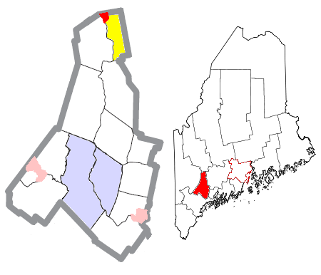
| 描述 | Map of the divisions of Androscoggin County, Maine, United States, with Livermore Falls highlighted: the census-designated place of Livermore Falls in red, and the rest of the town of Livermore Falls in yellow. The cities of Auburn and Lewiston are light blue; other towns are white; and pink areas are census-designated places within other towns. | ||
| 日期 | |||
| 来源 | Modified by me from this United States Census Bureau file. | ||
| 作者 | Nyttend | ||
| 授权 (二次使用本文件) |
US Government work is public domain, and my work is
|
文件历史
点击某个日期/时间查看对应时刻的文件。
| 日期/时间 | 缩略图 | 大小 | 用户 | 备注 | |
|---|---|---|---|---|---|
| 当前 | 2008年6月25日 (三) 20:26 | | 450 × 386(31 KB) | Nyttend(留言 | 贡献) | {{Information |Description=Map of the divisions of {{w|Androscoggin County, Maine|Androscoggin County}}, {{w|Maine}}, {{w|United States}}, with Livermore Falls highlighted: the {{w|census-designated place}} of {{w|Livermore Falls (CDP), Maine|Livermore Fa |
您不可以覆盖此文件。
文件用途
没有页面使用本文件。
全域文件用途
以下其他wiki使用此文件:
- ar.wikipedia.org上的用途
- azb.wikipedia.org上的用途
- en.wikipedia.org上的用途
- fa.wikipedia.org上的用途
- tt.wikipedia.org上的用途
- www.wikidata.org上的用途
- zh.wikipedia.org上的用途