File:Angers (Maine-et-Loire) (9654772842).jpg

Original file (2,272 × 1,704 pixels, file size: 1.39 MB, MIME type: image/jpeg)
Captions
Captions
Summary[edit]
_(9654772842).jpg&action=edit§ion=1)
| Description |
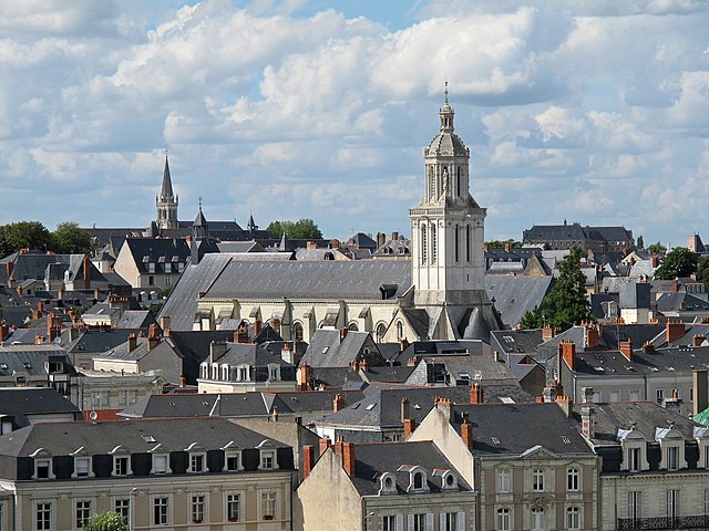
Vue générale d'Angers avec l'église de la Trinité. L'histoire de l'église de la Trinité commence avec la création de l'abbaye de Notre-Dame-de-la-Charité en 1028. Fondée par Foulque Nerra et sa femme Hildegarde, elle n'accueillait que des filles de la noblesse. Elle devint abbaye du Ronceray au XVIe siècle. Dans la deuxième moitié du XIe, l'abbaye voyait son lieu de culte envahi par les paroissiens. Les abbesses décidèrent donc de faire construire, tout près, une église paroissiale. Ce fut l'église de la Trinité, qui fut reconstruite un siècle plus tard. Le clocher à la croisée ne fut ajouté qu'au XVIe siècle. Le lanternon qui s'élève à la croisée, construit en 1540, il est attribué au grand architecte angevin de la Renaissance, Jean de l'Espine. Les statues des évangélistes sont un ajout du XIXe siècle.
The history of the Church of the Trinity begins with the creation of the Abbey of Notre-Dame-de-la-Charity in 1028. Founded by Nerra Fulk and his wife Hildegarde, she received only girls of the nobility. She became Ronceray Abbey in the sixteenth century. In the second half of the eleventh, the abbey saw his place of worship invaded by parishioners. Abbesses therefore decided to build, close, a parish church. It was the Trinity Church, which was rebuilt a century later. The steeple cross was added in the sixteenth century. The domelight which stands at the crossroads, built in 1540, is attributed to the great Angevin Renaissance architect, Jean de l'Espine. The statues of the evangelists are adding the nineteenth century. |
| Date | Taken on 3 August 2013, 17:07 |
| Source | Angers (Maine-et-Loire) |
| Author | Daniel Jolivet |
| Camera location | | View this and other nearby images on: OpenStreetMap |
|---|
_(9654772842).jpg¶ms=047.474961_N_-000.561075_E_globe:Earth_type:camera_source:Flickr_&language=en)
Licensing[edit]
_(9654772842).jpg&action=edit§ion=2)
- You are free:
- to share – to copy, distribute and transmit the work
- to remix – to adapt the work
- Under the following conditions:
- attribution – You must give appropriate credit, provide a link to the license, and indicate if changes were made. You may do so in any reasonable manner, but not in any way that suggests the licensor endorses you or your use.
| This image was originally posted to Flickr by sybarite48 at https://flickr.com/photos/26082117@N07/9654772842. It was reviewed on 14 November 2017 by FlickreviewR 2 and was confirmed to be licensed under the terms of the cc-by-2.0. |
File history
Click on a date/time to view the file as it appeared at that time.
| Date/Time | Thumbnail | Dimensions | User | Comment | |
|---|---|---|---|---|---|
| current | 15:40, 14 November 2017 | | 2,272 × 1,704 (1.39 MB) | Thesupermat2 (talk | contribs) | Transferred from Flickr via Flickr2Commons |
You cannot overwrite this file.
File usage on Commons
There are no pages that use this file.
_(9654772842).jpg&oldid=795522531)