File:Antarctic Peninsula, the Larsen Ice Shelf, and the sea ice covered waters around the region.jpg
پرش به ناوبری
پرش به جستجو

اندازهٔ این پیشنمایش: ۴۶۸ × ۵۹۹ پیکسل. کیفیتهای دیگر: ۱۸۷ × ۲۴۰ پیکسل | ۳۷۵ × ۴۸۰ پیکسل | ۶۰۰ × ۷۶۸ پیکسل | ۸۰۰ × ۱٬۰۲۴ پیکسل | ۱٬۶۰۰ × ۲٬۰۴۸ پیکسل | ۵٬۰۰۰ × ۶٬۴۰۰ پیکسل.
پروندهٔ اصلی (۵٬۰۰۰ × ۶٬۴۰۰ پیکسل، اندازهٔ پرونده: ۴٫۵۱ مگابایت، نوع MIME پرونده: image/jpeg)
گزینهها
عنوان
شرحی یکخطی از محتوای این فایل اضافه کنید
خلاصه[ویرایش]
| توضیح |
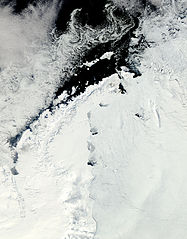
English: Clear view of the Antarctic Peninsula, the Larsen Ice Shelf, and the sea ice covered waters around the region. The Peninsula stands out as the raised terrain amidst the ice from the lower left to upper middle of the image. |
| تاریخ | |
| منبع | NASA Earth Observatory |
| پدیدآور | Jeff Schmaltz |
Image captured by the Moderate Resolution Imaging Spectroradiometer (MODIS) on NASA’s Aqua satellite. NASA image provided courtesy of the MODIS Rapid Response team.
اجازهنامه[ویرایش]
| این پرونده در مالکیت عمومی قرار دارد چرا که توسط ناسا ایجاد شده است. سیاست حق تکثیر ناسا بیان میکند که «مواد ناسا با حق تکثیر محافظت نمیشوند، مگراینکه ذکر شده باشد». (Template:PD-USGov، صفحهٔ سیاست حق تکثیر ناسا یا سیاست جیپیال استفاده از تصاویر را ببینید.) | ||
 |
هشدارها:
|
| برچسبها | این نگاره برچسپگذاری شدهاست: برچسپها را در ویکیانبار مشاهده کنید |
تاریخچهٔ پرونده
روی تاریخ/زمانها کلیک کنید تا نسخهٔ مربوط به آن هنگام را ببینید.
| تاریخ/زمان | بندانگشتی | ابعاد | کاربر | توضیح | |
|---|---|---|---|---|---|
| کنونی | ۱۷ اکتبر ۲۰۱۱، ساعت ۱۲:۱۵ | | ۵٬۰۰۰ در ۶٬۴۰۰ (۴٫۵۱ مگابایت) | Originalwana (بحث | مشارکتها) | {{Information |Description ={{en|1=Clear view of the Antarctic Peninsula, the Larsen Ice Shelf, and the sea ice covered waters around the region. The Peninsula stands out as the raised terrain amidst the ice from the lower left to upper middle of t |
شما نمیتوانید این پرونده را رونویسی کنید.
کاربرد پرونده
این پرونده در هیچ صفحهای به کار نرفته است.
کاربرد سراسری پرونده
ویکیهای دیگر زیر از این پرونده استفاده میکنند:
- کاربرد در ar.wikipedia.org
- کاربرد در cs.wikipedia.org
- کاربرد در en.wikipedia.org
- کاربرد در fa.wikipedia.org
- کاربرد در ko.wikipedia.org
- کاربرد در la.wikipedia.org
- کاربرد در mk.wikipedia.org
- کاربرد در ms.wikipedia.org
- کاربرد در nn.wikipedia.org
- کاربرد در pl.wikipedia.org
- کاربرد در pt.wikipedia.org
- کاربرد در ta.wikipedia.org
- کاربرد در uk.wikipedia.org
- کاربرد در zh.wikipedia.org