File:Antarctic Peninsula satellite image.jpg
跳转到导航
跳转到搜索

本预览的尺寸:490 × 599像素。 其他分辨率:196 × 240像素 | 392 × 480像素 | 628 × 768像素 | 837 × 1,024像素 | 1,509 × 1,846像素。
原始文件 (1,509 × 1,846像素,文件大小:706 KB,MIME类型:image/jpeg)
说明
说明
添加一行文字以描述该文件所表现的内容
摘要
[编辑]
| 描述 |
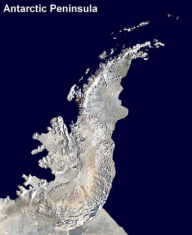
English: Antarctic Peninsula satellite image. An orthographic projection of NASA's Blue Marble data set (1 km resolution global satellite composite). "MODIS observations of polar sea ice were combined with observations of Antarctica made by the National Oceanic and Atmospheric Administration’s AVHRR sensor—the Advanced Very High Resolution Radiometer." Image was generated using a custom C program for handling the Blue Marble files, with orthographic projection formulas from MathWorld.
The black pixels are presumed to be due to missing data in the land/sea mask used in making the original Blue Marble image.
|
||
| 日期 | (UTC) | ||
| 来源 | |||
| 作者 |
|
许可协议
[编辑]
| 本作品已被作者Anna Frodesiak释出到公有领域。这适用于全世界。 在一些国家这可能不合法;如果是这样的话,那么: |
原始上传日志
[编辑]
This image is a derivative work of the following images:
- File:Antarctica_6400px_from_Blue_Marble.jpg licensed with PD-user
- 2006-10-05T14:21:53Z Davepape 6400x6400 (3472802 Bytes) touched up part with missing data
- 2006-10-05T07:49:09Z Davepape 6400x6400 (3472752 Bytes) {{Information |Description=[[w:Antarctica|Antarctica]]. An orthographic projection of NASA's Blue Marble data set (1 km resolution global satellite composite). "MODIS observations of polar sea ice were combined with observa
Uploaded with derivativeFX
文件历史
点击某个日期/时间查看对应时刻的文件。
| 日期/时间 | 缩略图 | 大小 | 用户 | 备注 | |
|---|---|---|---|---|---|
| 当前 | 2009年4月5日 (日) 23:08 | | 1,509 × 1,846(706 KB) | Anna Frodesiak(留言 | 贡献) | {{Information |Description=Antarctic Peninsula satellite image. An orthographic projection of NASA's Blue Marble data set (1 km resolution global satellite composite). "MODIS observations of polar sea ice were combined with observations of Antarctica made |
您不可以覆盖此文件。
文件用途
没有页面使用本文件。
全域文件用途
以下其他wiki使用此文件:
- af.wikipedia.org上的用途
- ast.wikipedia.org上的用途
- bs.wikipedia.org上的用途
- ca.wikipedia.org上的用途
- da.wikipedia.org上的用途
- en.wikipedia.org上的用途
- Antarctic Peninsula
- Mount Jackson (Antarctica)
- Trinity Peninsula
- Bowman Coast
- Breaker Island
- Dream Island
- Christine Island
- Cormorant Island
- Eichorst Island
- Shortcut Island
- Biscoe Point
- Loubet Coast
- Halfway Island (Palmer Archipelago)
- Gerlache Strait
- Hermit Island (Antarctic)
- Humble Island
- Janus Island
- Laggard Island
- Limitrophe Island
- Lipps Island
- Ohlin Island
- Outcast Islands
- Torgersen Island
- Spume Island
- Stepping Stones (islands)
- Surge Rocks
- Orville Coast
- Black Coast
- Wilkins Coast
- Dyer Plateau
- Fallières Coast
- English Coast
- Nordenskjöld Coast
- Quintana Island
- Doumer Island
- Bremen Island
- Neumayer Channel
- Smooth Island (Antarctica)
- Wilhelm Archipelago
- Betbeder Islands
- Sigma Islands
- Yalour Islands
查看此文件的更多全域用途。