File:Antarctic shelf ice hg.png
跳转到导航
跳转到搜索

本预览的尺寸:800 × 494像素。 其他分辨率:320 × 197像素 | 640 × 395像素 | 1,024 × 632像素 | 1,280 × 790像素 | 2,834 × 1,749像素。
原始文件 (2,834 × 1,749像素,文件大小:196 KB,MIME类型:image/png)
说明
说明
添加一行文字以描述该文件所表现的内容
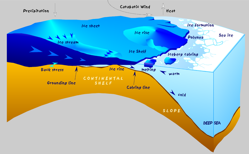
The Antarctic coast with glaciological and oceanographic processes

|
此geology图片可使用矢量图形重新创建为SVG文件。这具有很多好处;更多信息请参见共享资源:待清理媒体。如果存在此图片的SVG格式,请将其上传,然后将此模板替换为
{{vector version available|新图片名称}}。
建议您将SVG命名为“Antarctic shelf ice hg.svg”,这样在使用Vector version available(或Vva)模板时就不需要填写新图片名称参数。 |
SVG version : File:Antarctic_shelf_ice_fr.svg
摘要[编辑]
| 描述 |
English: Sketch of the Antarctic coast with glaciological and oceanographic processes.
Deutsch: Schematische Darstellung glaziologischer und ozeanographischer Prozesse an der Küste der Antarktis. Über dem antarktischen Eisschild fällt Niederschlag in Form von Schnee (Precipitation). Der Eisschild (Ice sheet) ist weitgehend am Untergrund festgefroren (back stress) und hat sich bis zu einer Mächtigkeit von über 4000 m aufgebaut. Das Eis fließt nach allen Seiten vom Kontinent ab, z.T. konzentriert in Eisströmen (Ice stream). An der Küste verliert das Eis im Bereich der Aufsetzlinie (Grounding line) den Kontakt zum Untergrund, wird deutlich dünner (einige 100 m) und bildet über dem Schelf (Continental shelf) ein Schelfeis (Ice shelf) = Eis, das noch mit dem Eisschild verbunden ist, aber bereits schwimmt. Fließt das Schelfeis über eine Untiefe, entstehen Eisrücken (Ice rise). An der Schelfeiskante brechen Tafeleisberge ab (Calving line, Iceberg calving), die auf ihrem Weg um die Antarktis in wärmerem Wasser schmelzen. Eine Küstenpolynya entsteht, wenn kalte ablandige Winde (Catabatic wind) das Meereis (Sea ice) von der Küste wegtreiben. In Verbindung mit der Neueisbildung entsteht kaltes, salzreiches und damit schweres Wasser, das den Kontinentalhang (Slope) herabfließt und den wesentlichen Mechanismus für die Bildung des ozeanischen Bodenwassers in der Tiefsee (Deep sea) darstellt. |
| 日期 | |
| 来源 | 自己的作品 |
| 作者 | Hannes Grobe, Alfred Wegener Institute for Polar and Marine Research, Bremerhaven, Germany |
| 授权 (二次使用本文件) |
Own work, share alike, attribution required (Creative Commons CC-BY-SA-2.5) |
许可协议[编辑]
我,本作品著作权人,特此采用以下许可协议发表本作品:
本文件采用知识共享署名-相同方式共享 2.5 通用许可协议授权。
- 您可以自由地:
- 共享 – 复制、发行并传播本作品
- 修改 – 改编作品
- 惟须遵守下列条件:
- 署名 – 您必须对作品进行署名,提供授权条款的链接,并说明是否对原始内容进行了更改。您可以用任何合理的方式来署名,但不得以任何方式表明许可人认可您或您的使用。
- 相同方式共享 – 如果您再混合、转换或者基于本作品进行创作,您必须以与原先许可协议相同或相兼容的许可协议分发您贡献的作品。
文件历史
点击某个日期/时间查看对应时刻的文件。
| 日期/时间 | 缩略图 | 大小 | 用户 | 备注 | |
|---|---|---|---|---|---|
| 当前 | 2016年10月6日 (四) 22:56 | | 2,834 × 1,749(196 KB) | Cmdrjameson(留言 | 贡献) | Compressed with pngout. Reduced by 117kB (37% decrease). |
| 2006年7月21日 (五) 23:05 |  | 2,834 × 1,749(314 KB) | Hgrobe(留言 | 贡献) | {{Information| |Description= |Source=own work |Date=2000-04-07 |Author=~~~~ |Permission=Own work, share alike, attribution required (Creative Commons CC-BY-SA-2.5) |other_versions= }} {{self|cc-by-sa-2.5}} Category:Ice, Antarctica |
您不可以覆盖此文件。
文件用途
以下8个页面使用本文件:
全域文件用途
以下其他wiki使用此文件:
- als.wikipedia.org上的用途
- ar.wikipedia.org上的用途
- ast.wikipedia.org上的用途
- beta.wikiversity.org上的用途
- ca.wikipedia.org上的用途
- cs.wikipedia.org上的用途
- da.wikipedia.org上的用途
- da.wikibooks.org上的用途
- de.wikipedia.org上的用途
- el.wikipedia.org上的用途
- en.wikipedia.org上的用途
- en.wikiversity.org上的用途
- eo.wikipedia.org上的用途
- es.wikipedia.org上的用途
- eu.wikipedia.org上的用途
- fa.wikipedia.org上的用途
- fi.wikipedia.org上的用途
- fr.wikipedia.org上的用途
- gl.wikipedia.org上的用途
- he.wikipedia.org上的用途
- hi.wikipedia.org上的用途
- hu.wikipedia.org上的用途
- ig.wikipedia.org上的用途
查看本文件的更多全域用途。
元数据
分类:
- Ice shelves of Antarctica
- Diagrams of ice shelves
- Diagrams of ice sheets
- Katabatic wind diagrams
- Katabatic wind in Antarctica
- Diagrams of the Antarctic
- Diagrams of glaciers
- Glacier mass balance diagrams
- Glaciology of Antarctica
- Glaciological diagrams of Antarctica
- Glacial geomorphology diagrams
- English-language diagrams