File:Antarctica (4), Adelaide Island, Stonehouse Bay.JPG
Ir a la navegación
Ir a la búsqueda

Tamaño de esta previsualización: 800 × 531 píxeles. Otras resoluciones: 320 × 213 píxeles | 640 × 425 píxeles | 1024 × 680 píxeles | 1280 × 850 píxeles | 1716 × 1140 píxeles.
Archivo original (1716 × 1140 píxeles; tamaño de archivo: 449 kB; tipo MIME: image/jpeg)
Leyendas
Leyendas
Añade una explicación corta acerca de lo que representa este archivo
Resumen
[editar],_Adelaide_Island,_Stonehouse_Bay.JPG&action=edit§ion=1)
| Descripción |
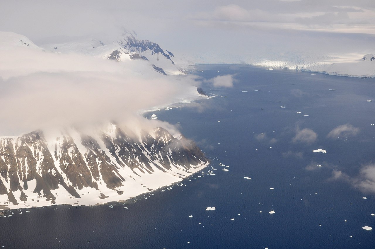
English: This picture is from the SW Antarctic Peninsula region.
It's an aerial view, looking West, from a position over Laubeuf Fjord to a part of Adelaide Island's east coast. In the foreground on the left is Sighing Peak, which forms the NE extremity of Adelaide Island's Wright Peninsula. The mountains behind it are the Stokes Peaks. The channel in front of Sighing Peak is called Cole Channel (and is actually a part of Laubeuf Fjord). The large body of water on the right is Stonehouse Bay. In the upper right hand corner of the picture, at the western end of Stonehouse Bay, is the huge and heavily crevassed Shambles Glacier; Adelaide Island's largest glacier. To the right of the glacier, at the extreme edge of the picture, is Dewar Nunatak. |
| Fecha | |
| Fuente | Trabajo propio |
| Autor | Vincent van Zeijst |
•
| Posición de la cámara | | Ubicación de esta y otras imágenes en: OpenStreetMap |
|---|
,_Adelaide_Island,_Stonehouse_Bay.JPG¶ms=-67.398517_N_-067.872161_E_globe:Earth_type:camera_heading:270.00&language=es)
Licencia
[editar],_Adelaide_Island,_Stonehouse_Bay.JPG&action=edit§ion=2)
Yo, el titular de los derechos de autor de esta obra, la publico en los términos de la siguiente licencia:
Este archivo se encuentra bajo la licencia Creative Commons Genérica de Atribución/Compartir-Igual 3.0.
- Eres libre:
- de compartir – de copiar, distribuir y transmitir el trabajo
- de remezclar – de adaptar el trabajo
- Bajo las siguientes condiciones:
- atribución – Debes otorgar el crédito correspondiente, proporcionar un enlace a la licencia e indicar si realizaste algún cambio. Puedes hacerlo de cualquier manera razonable pero no de manera que sugiera que el licenciante te respalda a ti o al uso que hagas del trabajo.
- compartir igual – En caso de mezclar, transformar o modificar este trabajo, deberás distribuir el trabajo resultante bajo la misma licencia o una compatible como el original.
Historial del archivo
Haz clic sobre una fecha y hora para ver el archivo tal como apareció en ese momento.
| Fecha y hora | Miniatura | Dimensiones | Usuario | Comentario | |
|---|---|---|---|---|---|
| actual | 22:29 10 mar 2011 | | 1716 × 1140 (449 kB) | Loranchet (discusión | contribs.) | {{Information |Description ={{en|1=This picture is from the SW Antarctic Peninsula region. It's an aerial view, looking West, from a position over Laubeuf Fjord to a part of Adelaide Island's east coast. In the foreground on the left is Sighing Peak, w |
No puedes sobrescribir este archivo.
Usos del archivo
La siguiente página usa este archivo:
Uso global del archivo
Las wikis siguientes utilizan este archivo:
- Uso en arz.wikipedia.org
- Uso en azb.wikipedia.org
- Uso en ceb.wikipedia.org
- Uso en de.wikipedia.org
- Uso en en.wikipedia.org
- Uso en es.wikipedia.org
- Uso en id.wikipedia.org
- Uso en it.wikipedia.org
- Uso en lld.wikipedia.org
- Uso en mk.wikipedia.org
- Uso en nn.wikipedia.org
- Uso en pl.wikipedia.org
- Uso en sv.wikipedia.org
- Uso en www.wikidata.org
- Uso en zh.wikipedia.org
,_Adelaide_Island,_Stonehouse_Bay.JPG&oldid=798907497)