File:Anzac plateaus and ridges.png
Jump to navigation
Jump to search
No higher resolution available.
Anzac_plateaus_and_ridges.png (477 × 550 pixels, file size: 94 KB, MIME type: image/png)
Captions
Captions
Add a one-line explanation of what this file represents
Summary
[edit]
| Description |
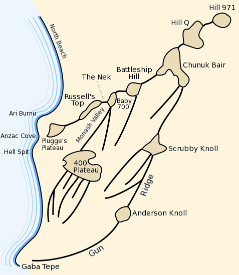
Map of the Anzac battlefield at en:Gallipoli depicting the main plateaus and ridges. Traced from marginal map in Ch.11, Vol. I "The Story of Anzac" of the en:Official History of Australia in the War of 1914-18 by en:C.E.W. Bean. |
| Date | 11 March 2004 (original upload date) |
| Source | Transferred from en.wikipedia to Commons. |
| Author | Gsl at English Wikipedia |
Licensing
[edit]
| This work has been released into the public domain by its author, Gsl at English Wikipedia. This applies worldwide. In some countries this may not be legally possible; if so: Gsl grants anyone the right to use this work for any purpose, without any conditions, unless such conditions are required by law. |
Original upload log
[edit]
The original description page was here. All following user names refer to en.wikipedia.
- 2004-03-11 11:25 Gsl 487×561×8 (38289 bytes) map of anzac

|
This battle map image could be re-created using vector graphics as an SVG file. This has several advantages; see Commons:Media for cleanup for more information. If an SVG form of this image is available, please upload it and afterwards replace this template with
{{vector version available|new image name}}.
It is recommended to name the SVG file “Anzac plateaus and ridges.svg”—then the template Vector version available (or Vva) does not need the new image name parameter. |
File history
Click on a date/time to view the file as it appeared at that time.
| Date/Time | Thumbnail | Dimensions | User | Comment | |
|---|---|---|---|---|---|
| current | 20:08, 25 April 2015 | | 477 × 550 (94 KB) | Hohum (talk | contribs) | Cropped border |
| 18:17, 21 June 2012 |  | 487 × 561 (98 KB) | Hohum (talk | contribs) | Colours | |
| 15:22, 5 July 2007 |  | 487 × 561 (37 KB) | Liftarn (talk | contribs) | {{Information |Description=Map of the Anzac battlefield at en:Gallipoli depicting the main plateaus and ridges. Traced from marginal map in Ch.11, Vol. I "The Story of Anzac" of the ''en:Official History of Australia in the War of 1914-18'' by |
You cannot overwrite this file.
File usage on Commons
The following page uses this file:
File usage on other wikis
The following other wikis use this file:
- Usage on ar.wikipedia.org
- Usage on be-tarask.wikipedia.org
- Usage on en.wikipedia.org
- Usage on it.wikipedia.org
- Usage on ru.wikipedia.org