File:Arab World Green.svg
Zur Navigation springen
Zur Suche springen

Gröössi vor PNG-Vorschou vor SVG-Datei: 800 × 406 Pixel. Wyteri Ufflösige: 320 × 162 Pixel | 640 × 325 Pixel | 1.024 × 520 Pixel | 1.280 × 650 Pixel | 2.560 × 1.299 Pixel | 940 × 477 Pixel.
Originaldatei (SVG-Datei, Basisgrößi: 940 × 477 Pixel, Dateigrößi: 404 KB)
Bildtexte
Kurzbeschreibungen
Ergänze eine einzeilige Erklärung, was diese Datei darstellt.
Bschryybig[ändere]
| Bschryybig |
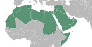
English: A map showing a portion of the Islamic world, North African country's are inhabited by the Amazigh an minority among them identified them self as Arab, in many cases it's what the feel despite not having an Semitic Middle eastern DNA. Egyptians are not Arabian either, but you have to understand they became Arab by culture. Last but not least the Middle East where the Arab originated from. The Islamic world has so many different race's that it is impossible to talk about an Arab world while the majority of the Muslims is not of Arab decent. The Islamic world is very cultural and racial diverse. It is their religion and spiritual bond that comes with it what connects them. Because of that, it's more appropriate and polite to talk about the Islamic world because that is what connects them. Besides that there is no Arabian Empire that rules over the whole Islamic world.
العربية: خريطة العالم العرب
ქართული: არაბული სამყაროს რუკა |
| Datum | |
| Quälle |
Diese Landkarte enthält Elemente, die von folgender Datei entnommen oder adaptiert wurden: |
| Urheber | T.seppelt |
| Anderi Versione |
|
| SVG‑Erstellung |

Lizänzierig[ändere]
| Ich, dr Urheberrächtsinhaber vu däm Wärch, tue s as gmeinfrej vereffentlige . Des giltet wältwyt. In mänke Staate chennt des rächtli nit megli syy. Wänn des imfall eso isch: Ich gib e jedem s bedingiglos Rächt, des Wärch jedwädere Zwäck z nutze, ußer s git gesetzlig erforderligi Bedingige. |
Dateiversione
Klick uf e Zytpunkt zu aazeige, wie s dert usgsäh het.
| Version vom | Vorschaubild | Mäß | Benutzer | Kommentar | |
|---|---|---|---|---|---|
| aktuell | 10:49, 3. Sep. 2022 | | 940 × 477 (404 KB) | SahinBasaran (Diskussion | Byträg) | Reverted to version as of 02:46, 3 September 2022 (UTC) |
| 10:49, 3. Sep. 2022 |  | 1.920 × 974 (311 KB) | SahinBasaran (Diskussion | Byträg) | Reverted to version as of 21:05, 2 September 2022 (UTC) | |
| 10:48, 3. Sep. 2022 |  | 2.400 × 1.218 (440 Bytes) | SahinBasaran (Diskussion | Byträg) | Reverted to version as of 21:00, 2 September 2022 (UTC) | |
| 02:46, 3. Sep. 2022 |  | 940 × 477 (404 KB) | M.Bitton (Diskussion | Byträg) | Reverted to version as of 03:34, 21 February 2016 (UTC): please don't perform tests on stable maps | |
| 21:05, 2. Sep. 2022 |  | 1.920 × 974 (311 KB) | SahinBasaran (Diskussion | Byträg) | Added Israel, Malta and Somaliland. | |
| 21:00, 2. Sep. 2022 |  | 2.400 × 1.218 (440 Bytes) | SahinBasaran (Diskussion | Byträg) | Added Israel, Malta and Somaliland. | |
| 03:34, 21. Feb. 2016 |  | 940 × 477 (404 KB) | Turnless (Diskussion | Byträg) | Fix format | |
| 20:45, 11. Apr. 2015 |  | 940 × 477 (431 KB) | T.seppelt (Diskussion | Byträg) | {{Information |Description ={{en|1=a map of the Arab World}} |Source ={{Attrib |1=BlankMap-Middle East.svg |2=NuclearVacuum }} |Author =T.seppelt |Date =2015-04-11 |Permission = |other_versions =[[:Fi... |
Du chasch die Datei nit iberschryybe.
Verwändig vu dr Datei
Die 7 Syte bruuche die Datei:
.png&redirect=no)
Wältwyti Dateinutzig
Die andere Wikis bruche die Datei:
- Gebruch uf af.wikipedia.org
- Gebruch uf als.wikipedia.org
- Gebruch uf arc.wikipedia.org
- Gebruch uf ar.wikipedia.org
- Gebruch uf arz.wikipedia.org
- Gebruch uf az.wiktionary.org
- Gebruch uf bg.wikipedia.org
- Gebruch uf bn.wikipedia.org
- Gebruch uf bs.wikipedia.org
- Gebruch uf de.wikipedia.org
- Gebruch uf de.wikinews.org
- Portal:Tunesien
- Portal:Irak
- Portal:Libanon
- Portal:Syrien
- Portal:Sudan
- Portal:Somalia
- Portal:Ägypten
- Portal:Saudi-Arabien
- Portal:Jemen
- Portal:Vereinigte Arabische Emirate
- Wikinews:Archiv/Hauptseite/2011/02
- Portal:Arabische Welt
- Vorlage:Portalnavigationsleiste Arabische Welt
- Wikinews:Pressestammtisch/Archiv/2011/Februar
- Portal:Libyen
- Gebruch uf en.wikipedia.org
- Gebruch uf en.wiktionary.org
- Gebruch uf es.wikipedia.org
- Gebruch uf fa.wikipedia.org
- Gebruch uf fa.wikiquote.org
- Gebruch uf fr.wikipedia.org
- Gebruch uf fy.wikipedia.org
- Gebruch uf gl.wikipedia.org
- Gebruch uf he.wikipedia.org
- Gebruch uf hu.wikipedia.org
- Gebruch uf hy.wikipedia.org
Wältwyti Verwändig vu däre Datei aaluege.