File:Aravaipa Creek (26631271841).jpg
Jump to navigation
Jump to search

Size of this preview: 400 × 600 pixels. Other resolutions: 160 × 240 pixels | 320 × 480 pixels | 512 × 768 pixels | 682 × 1,024 pixels | 1,365 × 2,048 pixels | 3,744 × 5,616 pixels.
Original file (3,744 × 5,616 pixels, file size: 7.63 MB, MIME type: image/jpeg)
Captions
Captions
Add a one-line explanation of what this file represents
Summary
[edit].jpg&action=edit§ion=1)
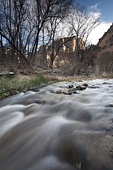
| Description | The 19,410-acre Aravaipa Canyon Wilderness is 120 miles southeast of Phoenix, Arizona in Graham and Pinal counties. The wilderness includes the 11-mile long Aravaipa Canyon, as well as, the surrounding tablelands and nine side canyons. Within the colorful 1,000-foot canyon walls, outstanding scenery, wildlife, and rich history are all protected. Seven species of native desert fish, desert bighorn sheep, and over 200 species of birds live among shady cottonwoods along the perennial waters of Aravaipa Creek. (BLM Photo by Bob Wick) |
| Date | |
| Source | Aravaipa Creek |
| Author | Bureau of Land Management (BLM) Arizona |
Licensing
[edit].jpg&action=edit§ion=2)
| This image is a work of a Bureau of Land Management* employee, taken or made as part of that person's official duties. As a work of the U.S. federal government, the image is in the public domain in the United States. *or predecessor organization |
| This image was originally posted to Flickr by BLMArizona at https://flickr.com/photos/141771506@N07/26631271841. It was reviewed on 8 January 2022 by FlickreviewR 2 and was confirmed to be licensed under the terms of the Public Domain Mark. |
File history
Click on a date/time to view the file as it appeared at that time.
| Date/Time | Thumbnail | Dimensions | User | Comment | |
|---|---|---|---|---|---|
| current | 13:46, 9 October 2021 | | 3,744 × 5,616 (7.63 MB) | StellarD (talk | contribs) | Transferred from Flickr via #flickr2commons |
You cannot overwrite this file.
File usage on Commons
There are no pages that use this file.
.jpg&oldid=807857879)