File:Archaeological site of Philippi BW 2017-10-05 12-54-40.jpg
Original file (6,016 × 4,000 pixels, file size: 10.3 MB, MIME type: image/jpeg)
Captions
Summary[edit]
DescriptionArchaeological site of Philippi BW 2017-10-05 12-54-40.jpg |
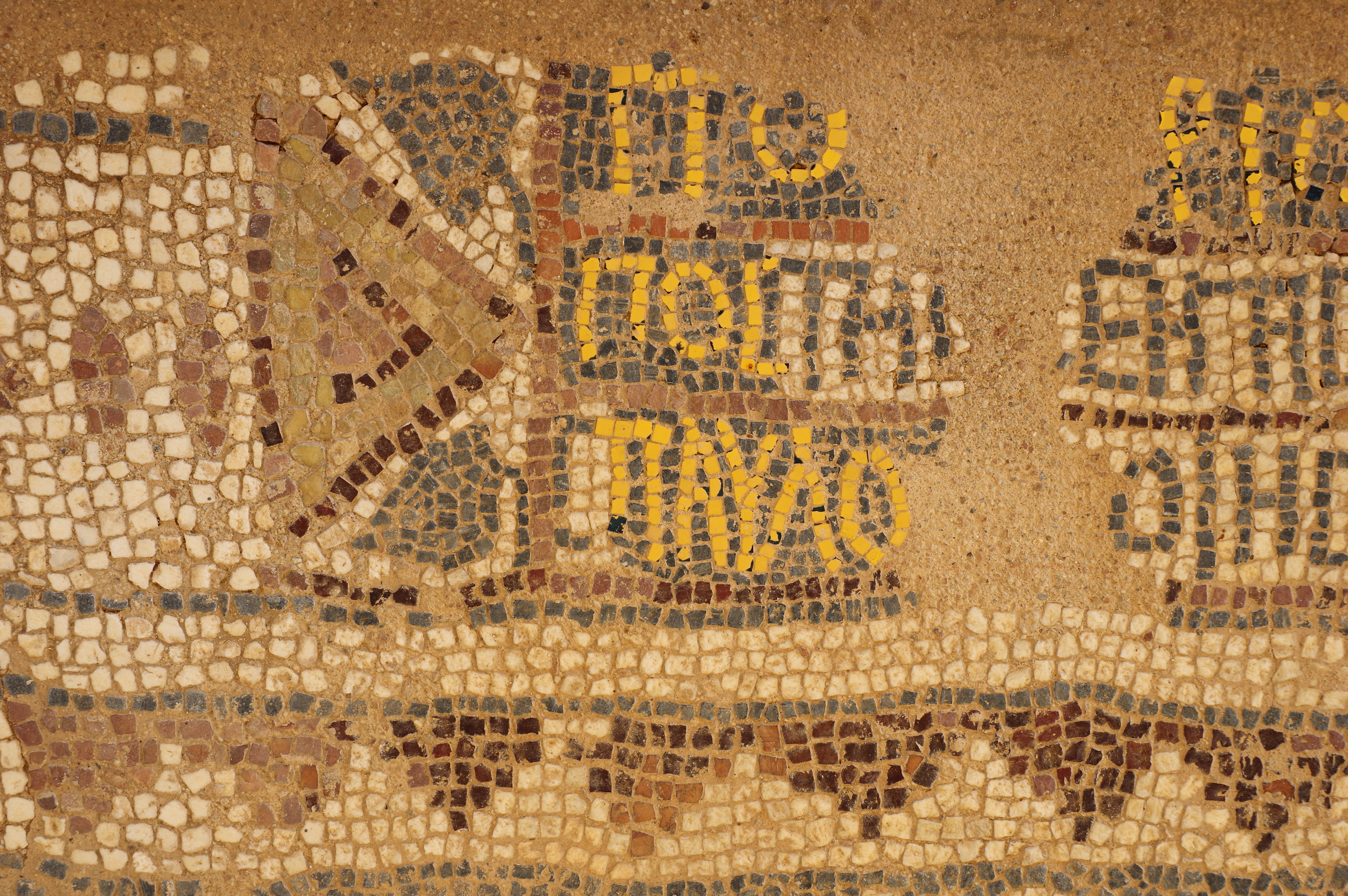
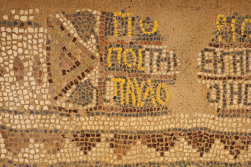
Deutsch: Philippi, Oktogonale Kirche, Fussbodenmosaik mit dem Namen Paulus in der dritten Zeile (Paulo, ΠΑΥΛΟ) English: Philippi, Octagonal Basilica, floor mosaic with the name of St. Paul in the third line (Paulo, ΠΑΥΛΟ) |
Date | |
Source | Own work |
Author | Berthold Werner |
Camera location | 41° 00′ 41.84″ N, 24° 17′ 04.32″ E | View this and other nearby images on: OpenStreetMap | 41.011623; 24.284532 |
---|
Licensing[edit]
- You are free:
- to share – to copy, distribute and transmit the work
- to remix – to adapt the work
- Under the following conditions:
- attribution – You must give appropriate credit, provide a link to the license, and indicate if changes were made. You may do so in any reasonable manner, but not in any way that suggests the licensor endorses you or your use.
- share alike – If you remix, transform, or build upon the material, you must distribute your contributions under the same or compatible license as the original.
Annotations InfoField | This image is annotated: View the annotations at Commons |
This image has been assessed using the Quality image guidelines and is considered a Quality image.
العربية ∙ جازايرية ∙ беларуская ∙ беларуская (тарашкевіца) ∙ български ∙ বাংলা ∙ català ∙ čeština ∙ Cymraeg ∙ Deutsch ∙ Schweizer Hochdeutsch ∙ Zazaki ∙ Ελληνικά ∙ English ∙ Esperanto ∙ español ∙ eesti ∙ euskara ∙ فارسی ∙ suomi ∙ français ∙ galego ∙ עברית ∙ हिन्दी ∙ hrvatski ∙ magyar ∙ հայերեն ∙ Bahasa Indonesia ∙ italiano ∙ 日本語 ∙ Jawa ∙ ქართული ∙ 한국어 ∙ kurdî ∙ Lëtzebuergesch ∙ lietuvių ∙ македонски ∙ മലയാളം ∙ मराठी ∙ Bahasa Melayu ∙ Nederlands ∙ Norfuk / Pitkern ∙ polski ∙ português ∙ português do Brasil ∙ rumantsch ∙ română ∙ русский ∙ sicilianu ∙ slovenčina ∙ slovenščina ∙ shqip ∙ српски / srpski ∙ svenska ∙ தமிழ் ∙ తెలుగు ∙ ไทย ∙ Tagalog ∙ Türkçe ∙ toki pona ∙ українська ∙ vèneto ∙ Tiếng Việt ∙ 中文 ∙ 中文(简体) ∙ 中文(繁體) ∙ +/− |
File history
Click on a date/time to view the file as it appeared at that time.
Date/Time | Thumbnail | Dimensions | User | Comment | |
---|---|---|---|---|---|
current | 19:47, 25 July 2018 | 6,016 × 4,000 (10.3 MB) | Berthold Werner (talk | contribs) | VicuñaUploader 1.23 |
You cannot overwrite this file.
File usage on Commons
The following 3 pages use this file:
File usage on other wikis
The following other wikis use this file:
- Usage on bs.wikipedia.org
- Usage on cs.wikipedia.org
- Usage on da.wikipedia.org
- Usage on en.wikipedia.org
- Usage on hy.wikipedia.org
- Usage on mk.wikipedia.org
- Usage on mt.wikipedia.org
- Usage on nl.wikipedia.org
- Usage on sh.wikipedia.org
- Usage on sl.wikipedia.org
Metadata
This file contains additional information such as Exif metadata which may have been added by the digital camera, scanner, or software program used to create or digitize it. If the file has been modified from its original state, some details such as the timestamp may not fully reflect those of the original file. The timestamp is only as accurate as the clock in the camera, and it may be completely wrong.
Camera manufacturer | RICOH IMAGING COMPANY, LTD. |
---|---|
Camera model | PENTAX K-3 |
Author | Berthold Werner |
Copyright holder | GFDL |
Exposure time | 1/50 sec (0.02) |
F-number | f/10 |
ISO speed rating | 100 |
Date and time of data generation | 12:54, 5 October 2017 |
Lens focal length | 36 mm |
Latitude | 41° 0′ 41.84″ N |
Longitude | 24° 17′ 4.31″ E |
Altitude | 63 meters above sea level |
City shown | Kavala |
Orientation | Normal |
Horizontal resolution | 300 dpi |
Vertical resolution | 300 dpi |
Software used | PENTAX K-3 Ver. 1.30 |
File change date and time | 12:54, 5 October 2017 |
Y and C positioning | Co-sited |
Exposure Program | Aperture priority |
Exif version | 2.3 |
Date and time of digitizing | 12:54, 5 October 2017 |
Meaning of each component |
|
APEX exposure bias | 0 |
Metering mode | Pattern |
Flash | Flash did not fire, compulsory flash suppression |
Supported Flashpix version | 1 |
Color space | sRGB |
Sensing method | One-chip color area sensor |
File source | Digital still camera |
Scene type | A directly photographed image |
Custom image processing | Normal process |
Exposure mode | Auto exposure |
White balance | Auto white balance |
Focal length in 35 mm film | 54 mm |
Scene capture type | Standard |
Contrast | Hard |
Saturation | Normal |
Sharpness | Hard |
Subject distance range | Close view |
GPS time (atomic clock) | 09:54 |
Satellites used for measurement | 09 |
Receiver status | Measurement in progress |
Measurement mode | 3-dimensional measurement |
Speed unit | Kilometers per hour |
Speed of GPS receiver | 0 |
Reference for direction of movement | True direction |
Direction of movement | 332.71 |
Reference for direction of image | True direction |
Direction of image | 302.15 |
Geodetic survey data used | WGS-84 |
GPS date | 5 October 2017 |
GPS tag version | 0.0.3.2 |
Sublocation of city shown | Philippi |
Code for country shown | GRC |
Country shown | Griechenland |
Structured data
5 October 2017
41°0'41.843"N, 24°17'4.315"E
image/jpeg
e15f83a6b4aebb9ab099bb79294f1f78c3ab9443
10,798,866 byte
4,000 pixel
6,016 pixel
- Files with coordinates missing SDC location of creation
- CC-BY-SA-3.0
- Taken with Pentax K-3
- Photographs by User:Berthold Werner/Griechenland/Philippi
- Greece photographs taken on 2017-10-05
- Uploaded with VicuñaUploader
- Images with annotations
- Quality images
- Quality images by User:Berthold Werner
- Pages with maps