File:Arctic sea ice extent in 2013 - maximum and minimum ice extents.png
出典:ウィキメディア・コモンズ (Wikimedia Commons)
ナビゲーションに移動
検索に移動

このプレビューのサイズ: 800 × 574 ピクセル。 その他の解像度: 320 × 230 ピクセル | 640 × 459 ピクセル | 810 × 581 ピクセル。
元のファイル (810 × 581 ピクセル、ファイルサイズ: 356キロバイト、MIME タイプ: image/png)
ファイル情報
構造化データ
キャプション
キャプション
このファイルの内容を1行で記述してください
概要[編集]
| 解説Arctic sea ice extent in 2013 - maximum and minimum ice extents.png |
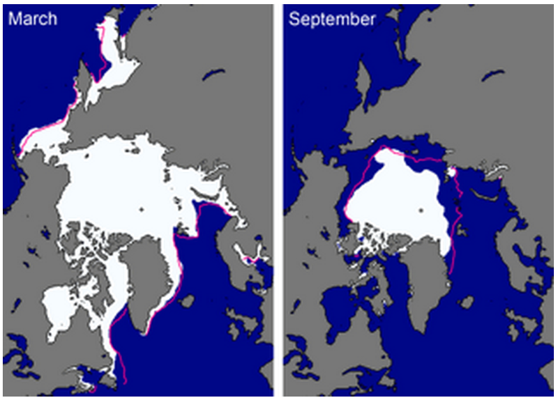
English: Sea ice extent in March 2013 (left) and September 2013 (right), illustrating the respective monthly averages during the winter maximum and summer minimum extents. The magenta lines indicate the median ice extents in March and September, respectively, during the period 1981-2010. Note that the median ice extents are computed over a different time interval than the one (1979-2000) used in previous Arctic Report Cards. |
| 日付 | |
| 原典 | The National Oceanic and Atmospheric Administration, - Arctic report card: Update for 2013 - http://www.arctic.noaa.gov/reportcard/sea_ice.html |
| 作者 | D. Perovich, S. Gerland, S. Hendricks, W. Meier, M. Nicolaus, J. Richter-Menge, M. Tschudi |
ライセンス[編集]
| Public domainPublic domainfalsefalse |
|
العربية ∙ čeština ∙ Deutsch ∙ Zazaki ∙ English ∙ español ∙ eesti ∙ suomi ∙ français ∙ hrvatski ∙ magyar ∙ italiano ∙ 日本語 ∙ 한국어 ∙ македонски ∙ മലയാളം ∙ Plattdüütsch ∙ Nederlands ∙ polski ∙ português ∙ română ∙ русский ∙ sicilianu ∙ slovenščina ∙ Türkçe ∙ Tiếng Việt ∙ 简体中文 ∙ 繁體中文 ∙ +/− |
 |
ファイルの履歴
過去の版のファイルを表示するには、その版の日時をクリックしてください。
| 日付と時刻 | サムネイル | 寸法 | 利用者 | コメント | |
|---|---|---|---|---|---|
| 現在の版 | 2014年10月19日 (日) 18:35 |  | 810 × 581 (356キロバイト) | Al83tito (トーク | 投稿記録) | User created page with UploadWizard |
このファイルは上書きできません。
ファイルの使用状況
このファイルを使用しているページはありません。
グローバルなファイル使用状況
以下に挙げる他のウィキがこの画像を使っています:
- en.wikipedia.org での使用状況
- ja.wikipedia.org での使用状況
- tr.wikipedia.org での使用状況
メタデータ
このファイルには、追加情報があります (おそらく、作成やデジタル化する際に使用したデジタルカメラやスキャナーが追加したものです)。
このファイルが元の状態から変更されている場合、修正されたファイルを完全に反映していない項目がある場合があります。
| 実効画像の幅 | 810 ピクセル |
|---|---|
| 実効画像の高さ | 581 ピクセル |
隠しカテゴリ: