File:Arizona Congressional Districts, 113th Congress.tif
跳转到导航
跳转到搜索
此TIF文件的JPG预览的大小:509 × 599像素。 其他分辨率:204 × 240像素 | 408 × 480像素 | 652 × 768像素 | 870 × 1,024像素 | 1,288 × 1,516像素。
原始文件 (1,288 × 1,516像素,文件大小:298 KB,MIME类型:image/tiff)
说明
说明
添加一行文字以描述该文件所表现的内容
摘要
[编辑]| 描述 |
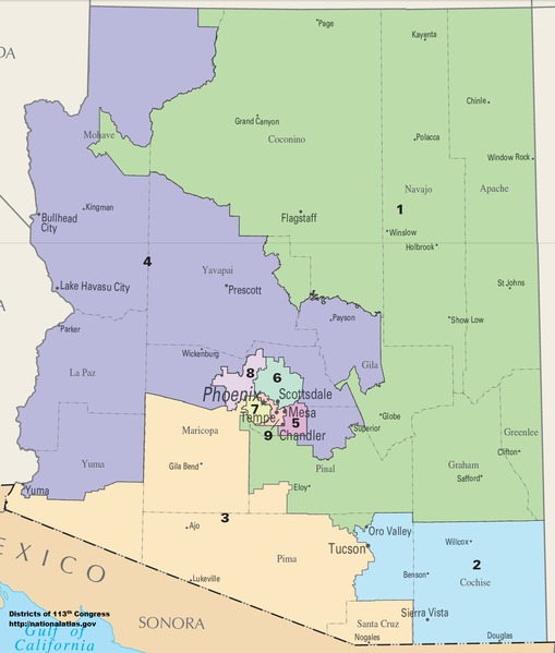
English: Map of Congressional Districts in the state of Arizona, reflecting district boundaries current to the 113th United States Congress. |
| 日期 | |
| 来源 | National Atlas of the United States |
| 作者 | Department of the Interior |
许可协议
[编辑]本地图取自美国国家地图集的某个版本。正如几乎所有美国联邦政府作品一样,来自国家地图集的作品在美国属于公有领域。
在线访问:NationalAtlas.gov | 1970年印刷版:国会图书馆、Perry-Castañeda图书馆
|
文件历史
点击某个日期/时间查看对应时刻的文件。
| 日期/时间 | 缩略图 | 大小 | 用户 | 备注 | |
|---|---|---|---|---|---|
| 当前 | 2014年1月31日 (五) 22:02 |  | 1,288 × 1,516(298 KB) | 7partparadigm(留言 | 贡献) | User created page with UploadWizard |
您不可以覆盖此文件。
文件用途
没有页面使用本文件。
全域文件用途
以下其他wiki使用此文件:
- fa.wikipedia.org上的用途
- fr.wikipedia.org上的用途
- hu.wikipedia.org上的用途
- ru.wikipedia.org上的用途
- simple.wikipedia.org上的用途
- uk.wikipedia.org上的用途
- zh.wikipedia.org上的用途