File:ArmeniaSevres.gif
跳转到导航
跳转到搜索

本预览的尺寸:800 × 526像素。 其他分辨率:320 × 211像素 | 640 × 421像素 | 1,024 × 674像素 | 1,280 × 842像素 | 2,245 × 1,477像素。
原始文件 (2,245 × 1,477像素,文件大小:298 KB,MIME类型:image/gif)
说明
说明
添加一行文字以描述该文件所表现的内容
摘要[编辑]
| 描述 |
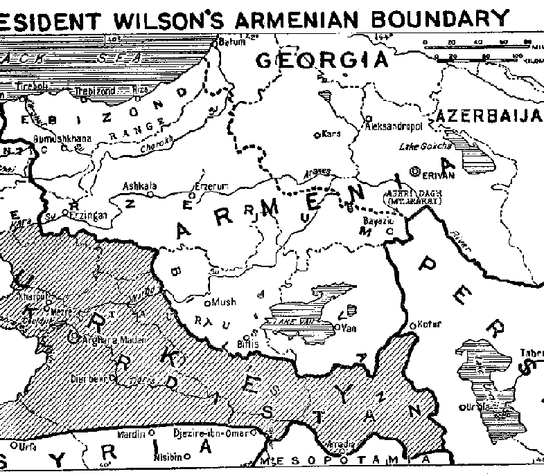
English: Map of Eastern Turkey, showing the extent of Turkish Armenia according to President Wilson's boundary decision in Treaty of Sèvres. |
| 日期 | |
| 来源 | http://www.gwpda.org/gifs/armenia.gif |
| 作者 | Lt. Colonel Lawrence Martin. Geographer of the Institute of Politics at Williamstown, Mass, 1921-27 |
许可协议[编辑]
|
|
 | |
 |
文件历史
点击某个日期/时间查看对应时刻的文件。
| 日期/时间 | 缩略图 | 大小 | 用户 | 备注 | |
|---|---|---|---|---|---|
| 当前 | 2021年6月30日 (三) 07:05 | | 2,245 × 1,477(298 KB) | Zero0000(留言 | 贡献) | Higher resolution and more of the original. |
| 2012年6月30日 (六) 18:15 |  | 785 × 685(30 KB) | Infestor(留言 | 贡献) |
您不可以覆盖此文件。
文件用途
没有页面使用本文件。
全域文件用途
以下其他wiki使用此文件:
- ar.wikipedia.org上的用途
- azb.wikipedia.org上的用途
- az.wikipedia.org上的用途
- fa.wikipedia.org上的用途
- hy.wikipedia.org上的用途
- ro.wikipedia.org上的用途
- tr.wikipedia.org上的用途
- zh.wikipedia.org上的用途