File:Arsia Mons PIA02804.jpg
出自Wikimedia Commons
跳至導覽
跳至搜尋
Arsia_Mons_PIA02804.jpg (524 × 462 像素,檔案大小:52 KB,MIME 類型:image/jpeg)
檔案資訊
結構化資料
說明
說明
添加單行說明來描述出檔案所代表的內容
摘要
[編輯]| 描述Arsia Mons PIA02804.jpg |
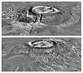
Two views of Arsia Mons, based on Viking orbiter imagery and Mars Global Surveyor elevation data, from the south (top) and north (bottom). Arsia Mons is the southernmost of the Tharsis Montes. It is depicted using a Viking image mosaic draped over MOLA topography. The topography shows the caldera structure and the massive flank breakouts that produced two major side lobes on opposite sides of the volcano. The vertical exaggeration is 10:1. |
| 來源 | http://photojournal.jpl.nasa.gov/catalog/PIA02804 |
| 作者 | NASA/MOLA Science Team |
| 此標籤不表示文件的著作權狀態。任何文件在附有此標籤的同時還需要一個有效的著作權標籤。請參閱許可協議說明頁面以了解更多資訊。 其他語言:
العربية ∙ беларуская (тарашкевіца) ∙ български ∙ català ∙ čeština ∙ dansk ∙ Deutsch ∙ English ∙ español ∙ فارسی ∙ français ∙ galego ∙ magyar ∙ հայերեն ∙ Bahasa Indonesia ∙ italiano ∙ 日本語 ∙ македонски ∙ മലയാളം ∙ Nederlands ∙ polski ∙ português ∙ русский ∙ sicilianu ∙ slovenščina ∙ Türkçe ∙ українська ∙ 简体中文 ∙ 繁體中文 ∙ +/− |
授權條款
[編輯]| Public domainPublic domainfalsefalse |
| 本作品由NASA創作,屬於公有領域。根據NASA的版權政策:“NASA的創作除非另有聲明否則不受版權保護。”(參見:Template:PD-USGov/zh,NASA版權政策或JPL圖像使用政策) |  | |
 |
警告:
|
原始上傳日誌
[編輯](All user names refer to en.wikipedia)
- 2006-07-14 23:41 Cuppysfriend 291×256×8 (17193 bytes) Two processed images of [[Arsia Mons]] taken by the [[Mars Global Surveyor]] Orbiter. Original Caption Released with Image: Two views of Arsia Mons, the southern most of the [[Tharsis montes]], shown as topography draped over a Viking image mosaic. MOLA
檔案歷史
點選日期/時間以檢視該時間的檔案版本。
| 日期/時間 | 縮圖 | 尺寸 | 使用者 | 備註 | |
|---|---|---|---|---|---|
| 目前 | 2012年9月15日 (六) 07:24 |  | 524 × 462(52 KB) | WolfmanSF(留言 | 貢獻) | higher resolution version of same image |
| 2007年8月11日 (六) 02:59 |  | 291 × 256(17 KB) | Webaware(留言 | 貢獻) | {{Information |Description=Two processed images of en:Arsia Mons taken by the en:Mars Global Surveyor Orbiter. Original Caption Released with Image: Two views of Arsia Mons, the southern most of the en:Tharsis Montes, shown as topography |
無法覆蓋此檔案。
檔案用途
下列頁面有用到此檔案:
全域檔案使用狀況
以下其他 wiki 使用了這個檔案:
- bjn.wikipedia.org 的使用狀況
- en.wikipedia.org 的使用狀況
- es.wikipedia.org 的使用狀況
- fr.wikipedia.org 的使用狀況
- gl.wikipedia.org 的使用狀況
- hi.wikipedia.org 的使用狀況
- hu.wikipedia.org 的使用狀況
- id.wikipedia.org 的使用狀況
- ja.wikipedia.org 的使用狀況
- jv.wikipedia.org 的使用狀況
- no.wikipedia.org 的使用狀況
- pt.wikipedia.org 的使用狀況
- ro.wikipedia.org 的使用狀況
- ta.wikipedia.org 的使用狀況
- uk.wikipedia.org 的使用狀況
- vi.wikipedia.org 的使用狀況
- zh.wikipedia.org 的使用狀況
