File:Arthur 2014 track.png
Aller à la navigation
Aller à la recherche

Taille de cet aperçu : 630 × 599 pixels. Autres résolutions : 252 × 240 pixels | 505 × 480 pixels | 808 × 768 pixels | 1 077 × 1 024 pixels | 2 153 × 2 048 pixels | 2 700 × 2 568 pixels.
Fichier d’origine (2 700 × 2 568 pixels, taille du fichier : 4,69 Mio, type MIME : image/png)
Légendes
Légendes
Ajoutez en une ligne la description de ce que représente ce fichier
Description
| Description |
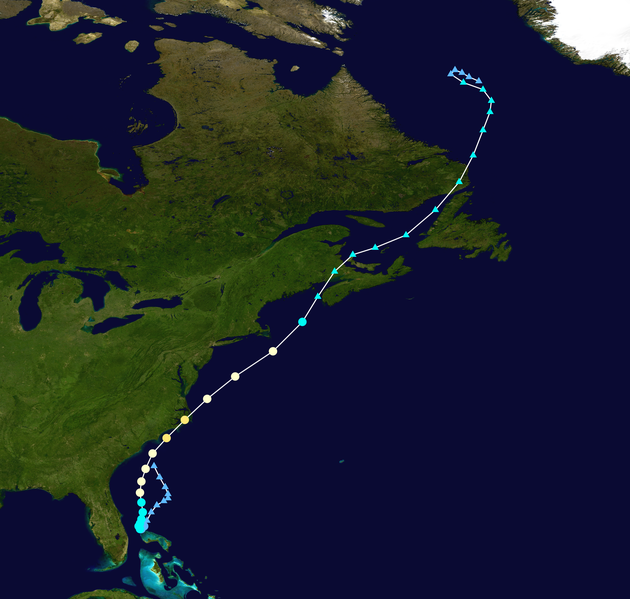
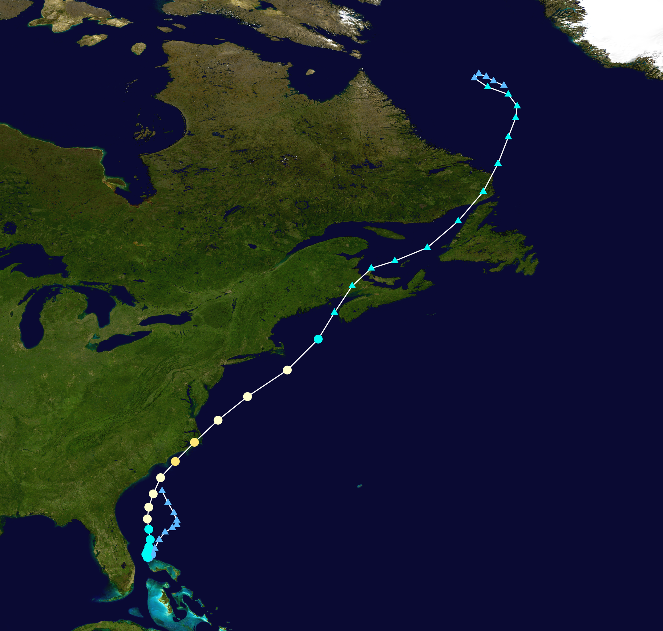
English: Track map of Hurricane Arthur of the 2014 Atlantic hurricane season. The points show the location of the storm at 6-hour intervals. The colour represents the storm's maximum sustained wind speeds as classified in the (see below), and the shape of the data points represent the nature of the storm, according to the legend below. Tropical depression (≤38 mph, ≤62 km/h)
Tropical storm (39–73 mph, 63–118 km/h)
Category 1 (74–95 mph, 119–153 km/h)
Category 2 (96–110 mph, 154–177 km/h)
Category 3 (111–129 mph, 178–208 km/h)
Category 4 (130–156 mph, 209–251 km/h)
Category 5 (≥157 mph, ≥252 km/h)
Unknown
Storm type |
||
| Date | 2014-06-28–2014-07-09 | ||
| Source | Created by Cyclonebiskit using Wikipedia:WikiProject Tropical cyclones/Tracks. The background image is from NASA. Tracking data is from the National Hurricane Center[1]. | ||
| Auteur | Cyclonebiskit | ||
| Source code | Track map data table, if present below, is in HURDAT2 or ATCF format. See format details in [2] and [3], respectively.
|
Conditions d’utilisation[modifier]
| Cette œuvre a été placée dans le domaine public par son auteur, Cyclonebiskit. Ceci s’applique dans le monde entier. Dans certains pays, ceci peut ne pas être possible ; dans ce cas : Cyclonebiskit accorde à toute personne le droit d’utiliser cette œuvre dans n’importe quel but, sans aucune condition, sauf celles requises par la loi. |
Historique du fichier
Cliquer sur une date et heure pour voir le fichier tel qu'il était à ce moment-là.
| Date et heure | Vignette | Dimensions | Utilisateur | Commentaire | |
|---|---|---|---|---|---|
| actuel | 21 janvier 2015 à 21:56 | | 2 700 × 2 568 (4,69 Mio) | Supportstorm (d | contributions) | Best track |
| 10 juillet 2014 à 03:05 |  | 2 700 × 2 310 (4,39 Mio) | Supportstorm (d | contributions) | Update | |
| 6 juillet 2014 à 14:03 |  | 2 000 × 1 347 (1,56 Mio) | Cyclonebiskit (d | contributions) | Add coordinates from the Canadian Hurricane Center | |
| 5 juillet 2014 à 14:22 |  | 2 000 × 1 236 (1,46 Mio) | Cyclonebiskit (d | contributions) | update | |
| 4 juillet 2014 à 12:28 |  | 2 700 × 1 669 (3,14 Mio) | Supportstorm (d | contributions) | Update | |
| 3 juillet 2014 à 18:42 |  | 2 700 × 1 669 (3,25 Mio) | Supportstorm (d | contributions) | Update | |
| 2 juillet 2014 à 12:18 |  | 2 000 × 1 236 (1,57 Mio) | Cyclonebiskit (d | contributions) | {{WPTC track map | author = Cyclonebiskit | name = Tropical Storm Arthur | article = Tropical Storm Arthur (2014) | season = 2013 Atlantic hurricane season | start = 2013-06-27 | end = 2013-07-02 | othersource=Tracking data from the {{w|National... |
Vous ne pouvez pas remplacer ce fichier.
Utilisations locales du fichier
La page suivante utilise ce fichier :
Utilisations du fichier sur d’autres wikis
Les autres wikis suivants utilisent ce fichier :
- Utilisation sur de.wikipedia.org
- Utilisation sur en.wikipedia.org
- Utilisation sur es.wikipedia.org
- Utilisation sur fi.wikipedia.org
- Utilisation sur fr.wikipedia.org
- Utilisation sur ko.wikipedia.org
- Utilisation sur pt.wikipedia.org
- Utilisation sur ru.wikipedia.org
- Utilisation sur www.wikidata.org
- Utilisation sur zh.wikipedia.org