File:Asher & Adams' Texas (Western Portion) 1874 UTA.jpg
Jump to navigation
Jump to search

Size of this preview: 446 × 599 pixels. Other resolutions: 178 × 240 pixels | 357 × 480 pixels | 571 × 768 pixels | 762 × 1,024 pixels | 1,524 × 2,048 pixels | 5,159 × 6,932 pixels.
Original file (5,159 × 6,932 pixels, file size: 8.3 MB, MIME type: image/jpeg)
Captions
Captions
Add a one-line explanation of what this file represents
Summary[edit]
| Title |
English: Asher & Adams' Texas [Western Portion] |
||||||||||||||||||||||||||
| Description |
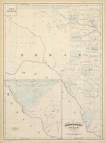
English: New York atlas publishers Asher & Adams' map of the western portion of Texas shows minimal topographical features along with western counties established before 1871, when an enormous Pecos County was created from El Paso and Presidio Counties. The projected route of the Texas & Pacific Railway crosses the plain from east to west, continuing into the inset of far western Texas at lower left. Construction on this railroad had halted in Dallas due to the financial panic of 1873 and it did not resume until 1876, when a small section was extended to nearby Fort Worth. Further work on the western portion of the railroad shown in this map did not resume until 1880. |
||||||||||||||||||||||||||
| Date | |||||||||||||||||||||||||||
| Source | UTA Libraries Cartographic Connections: map / text | ||||||||||||||||||||||||||
| Creator |
Asher & Adams |
||||||||||||||||||||||||||
| Credit line |
English: The University of Texas at Arlington Libraries Special Collections |
||||||||||||||||||||||||||
| Geotemporal data | |||||||||||||||||||||||||||
| Map location | Texas | ||||||||||||||||||||||||||
| Georeferencing | If inappropriate please set warp_status = skip to hide. | ||||||||||||||||||||||||||
| Bibliographic data | |||||||||||||||||||||||||||
| Publication |
New Commercial, Topographical, and Statistical… Atlas of the United States |
||||||||||||||||||||||||||
| Volume | 1 | ||||||||||||||||||||||||||
| Page(s) | 57–58 | ||||||||||||||||||||||||||
| Place of publication | New York City | ||||||||||||||||||||||||||
| Publisher |
Asher & Adams |
||||||||||||||||||||||||||
| Archival data | |||||||||||||||||||||||||||
| Collection |
|
||||||||||||||||||||||||||
| Dimensions | height: 57.5 cm (22.6 in); width: 42 cm (16.5 in) | ||||||||||||||||||||||||||
| Medium | colored lithograph on paper | ||||||||||||||||||||||||||
| artwork-references |
Huseman, Ben W. (2018) Paths to Highways: Routes of Exploration, Commerce, and Settlement, Arlington: The University of Texas at Arlington Libraries, no. 83 , pp. 48–49 Ristow, Walter W. (1985) American Maps and Mapmakers: Commercial Cartography in the Nineteenth Century, Detroit: Wayne State University Press, p. 441 Gournay, Luke (1995) Texas Boundaries: Evolution of the State’s Counties, College Station: Texas A&M University Press, pp. 87–90 George C. Werner (July 16, 2016). Texas and Pacific Railway. Handbook of Texas Online. Texas State Historical Association. Retrieved on August 20, 2019. |
||||||||||||||||||||||||||
| Other versions |
|
||||||||||||||||||||||||||
_1871_UTA.jpg)
_1874_UTA.jpg&action=edit§ion=1)
Licensing[edit]
_1874_UTA.jpg&action=edit§ion=2)

|
This file was provided to Wikimedia Commons by the University of Texas at Arlington Libraries as part of a cooperation project. The University of Texas at Arlington Libraries is part of the University of Texas at Arlington, a public research university located in Arlington, Texas.
|
This work is in the public domain in the United States because it was published (or registered with the U.S. Copyright Office) before January 1, 1929.
Public domain works must be out of copyright in both the United States and in the source country of the work in order to be hosted on the Commons. If the work is not a U.S. work, the file must have an additional copyright tag indicating the copyright status in the source country.
Note: This tag should not be used for sound recordings. |
File history
Click on a date/time to view the file as it appeared at that time.
| Date/Time | Thumbnail | Dimensions | User | Comment | |
|---|---|---|---|---|---|
| current | 17:55, 3 June 2021 | | 5,159 × 6,932 (8.3 MB) | Michael Barera (talk | contribs) | == {{int:filedesc}} == {{Map |title = ''Asher & Adams’ Texas [stern Portion]'' |description = {{en|New York atlas publishers Asher & Adams' map of the western portion of Texas shows minimal topographical features along with western counties established before 1871, when an enormous Pecos County was created from El Paso and Presidio Counties. The projected route of the Texas & Pacific Railway crosses the plain from eastto west, continuing into the inset of far western Texas... |
You cannot overwrite this file.
File usage on Commons
The following 2 pages use this file:
_1874_UTA.jpg&oldid=805024510)