File:Ashfall from Pinatubo, 1991.jpg
Here nagîvasyonê
Here lêgerînê
Versyonekî jê mezintir tune.
Ashfall_from_Pinatubo,_1991.jpg (726 × 489 pixel, mezinbûnê data: 78 KB, MIME-typ: image/jpeg)
Captions
Captions
Add a one-line explanation of what this file represents
Danasîn[biguhêre]
| Danasîn |
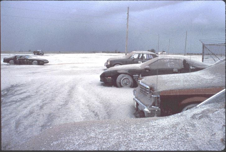
English: Ashfall from Mount Pinatubo's 1991 eruption. Snowlike blanket of tephra deposit of June 16, 1991, about 9 cm thick, in the eastern part of Clark Air Base, about 25 km east of Mount Pinatubo. |
| Dîrok | |
| Çavkanî | http://vulcan.wr.usgs.gov/Volcanoes/Philippines/Pinatubo/images.html, see Fig. 13 at [1] |
| Xwedî | Photograph by R.P. Hoblitt |
Lîsans[biguhêre]
This image is in the public domain in the United States because it only contains materials that originally came from the United States Geological Survey, an agency of the United States Department of the Interior. For more information, see the official USGS copyright policy.
|
Dîroka daneyê
Ji bo dîtina guhartoya wê demê bişkoka dîrokê bitikîne.
| Dîrok/Katjimêr | Wêneyê biçûk | Mezinahî | Bikarhêner | Şirove | |
|---|---|---|---|---|---|
| niha | 13:58, 6 çiriya pêşîn 2020 | | 726 x 489 (78 KB) | Fulvio314 (gotûbêj | beşdarî) | - watermark |
| 10:06, 8 adar 2006 |  | 726 x 489 (60 KB) | Magalhães (gotûbêj | beşdarî) | Ashfall from Mount Pinatubo's 1991 eruption. From [http://vulcan.wr.usgs.gov/Volcanoes/Philippines/Pinatubo/images.html http://vulcan.wr.usgs.gov/Volcanoes/Philippines/Pinatubo/images.html]. {{PD-USGov-Interior-USGS}} Category:Mount Pinatubo |
Tu nikarî cardin li ser vê dosyeyê binivîsînî.
Bikaranîna pelê
Rûpelekî ku ji vê dosyeyê bi kar tîne nîne.
Bikaranîna gerdûnî ya pelê
Ev wîkiyên di rêzê de vê pelê bi kar tînin:
- Bikaranîna di af.wikipedia.org de
- Bikaranîna di beta.wikiversity.org de
- Bikaranîna di bg.wikipedia.org de
- Bikaranîna di ca.wikipedia.org de
- Bikaranîna di cs.wikipedia.org de
- Bikaranîna di de.wikipedia.org de
- Bikaranîna di en.wikipedia.org de
- Bikaranîna di en.wikiversity.org de
- User:Marshallsumter/Keynote lectures (draft)/Astronomy
- Liquids/Liquid objects/Rains
- User:Marshallsumter/Original research/Volcanoes
- User:Marshallsumter/Original research/Volcanoes/Quiz
- Liquids/Liquid objects/Rains/Quiz
- Planets/Geology
- User:Marshallsumter/Rocks/Rocky objects
- Draft:Original research/Liquids/Quiz
- User:Marshallsumter/Radiation astronomy/Colors
- Volcanoes/Campi Flegrei/Quiz
- Volcanoes/Mount Rainier/Quiz
- Volcanoes/Mount Redoubt/Quiz
- Volcanoes/Mount Somma/Quiz
- Volcanoes/Mount Tambora/Quiz
- Volcanoes/Mount Vesuvius/Quiz
- Volcanoes/Volcanic activity/Quiz
- Volcanoes/Volcanology/Quiz
- Liquids/Liquid objects/Quiz
- User:Marshallsumter/Rocks/Rocky objects/Earth/Quiz
- Volcanoes/Mount St. Helens/Quiz
- User:Marshallsumter/Radiation astronomy/Astronomy
- User:Marshallsumter/Radiation astronomy/Earth
- User:Marshallsumter/Radiation astronomy2/Volcanoes
- Bikaranîna di eo.wikipedia.org de
- Bikaranîna di fa.wikipedia.org de
- Bikaranîna di fr.wikipedia.org de
- Bikaranîna di he.wikipedia.org de
- Bikaranîna di it.wikipedia.org de
- Bikaranîna di ja.wikipedia.org de
- Bikaranîna di ku.wikipedia.org de
- Bikaranîna di lt.wikipedia.org de
- Bikaranîna di mk.wikipedia.org de
- Bikaranîna di nl.wikipedia.org de
- Bikaranîna di sk.wikipedia.org de