File:Asia1899.JPG
跳转到导航
跳转到搜索
本预览的尺寸:735 × 600像素。 其他分辨率:294 × 240像素 | 588 × 480像素 | 941 × 768像素 | 1,255 × 1,024像素 | 2,510 × 2,048像素 | 3,198 × 2,610像素。
原始文件 (3,198 × 2,610像素,文件大小:3.64 MB,MIME类型:image/jpeg)
说明
说明
添加一行文字以描述该文件所表现的内容
摘要
[编辑]| 描述 |
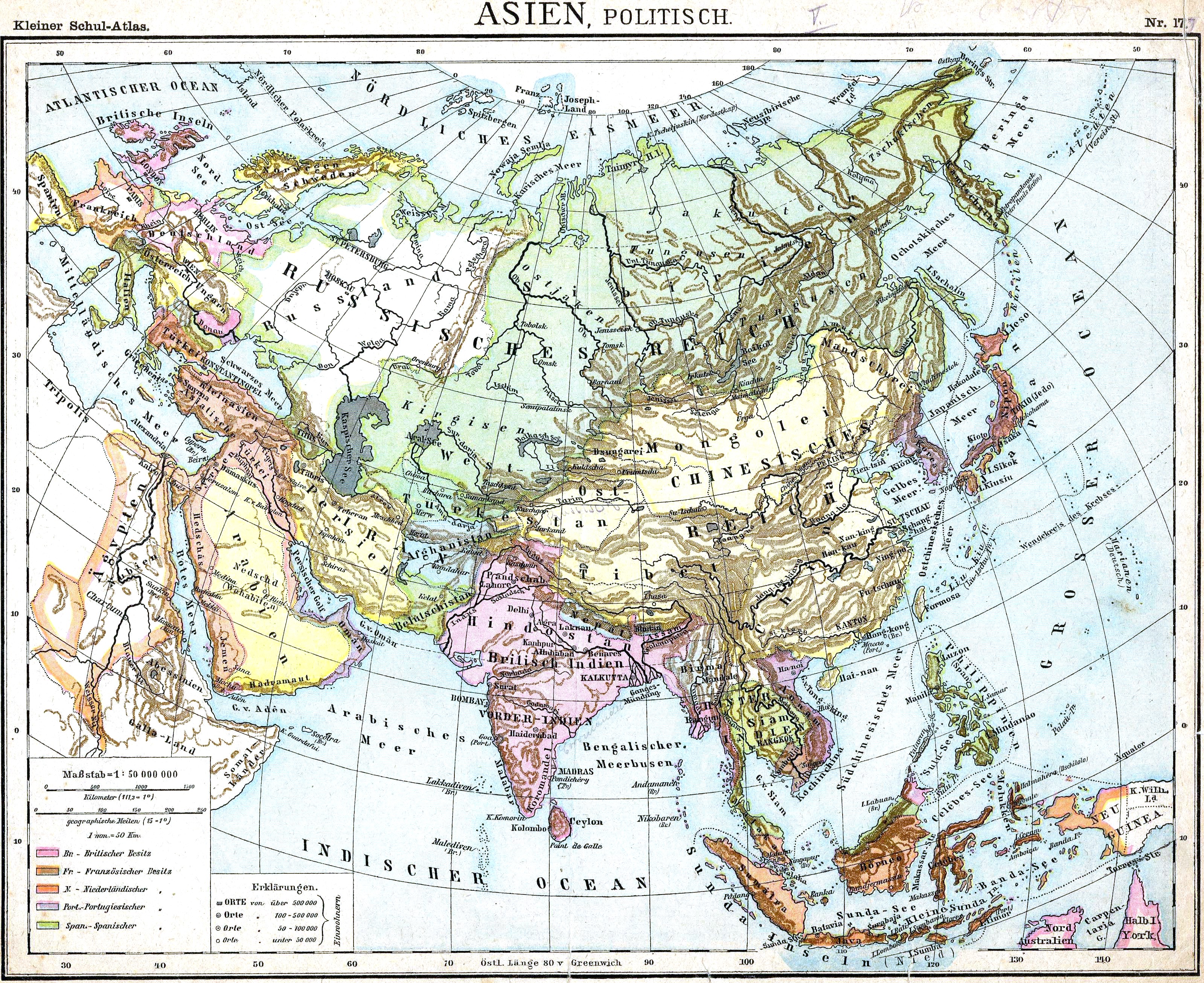
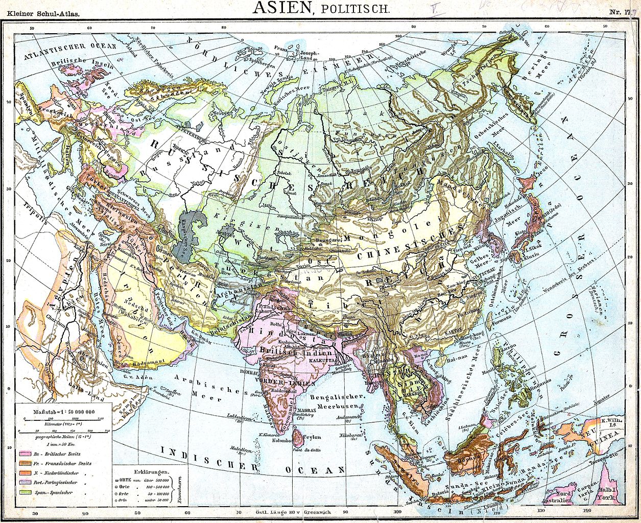
English: Political Map of Asia |
|||||||||||||||||||||||
| 日期 | 1893年前后 | |||||||||||||||||||||||
| 来源 | "Volksschul-Atlas", Dreihundertste Auflage, George Westermann in Braunschweig, 1899. Scan made by Olahus | |||||||||||||||||||||||
| 作者 |
|
|||||||||||||||||||||||
.jpg)
.JPG)
许可协议
[编辑]
|
本作品在其来源国以及其他著作权期限是作者逝世后100年或以下的国家和地区属于公有领域。 | |
| 本文件已被确认为免除已知的著作权法限制(包括所有相关权利)。 | |
文件历史
点击某个日期/时间查看对应时刻的文件。
| 日期/时间 | 缩略图 | 大小 | 用户 | 备注 | |
|---|---|---|---|---|---|
| 当前 | 2010年3月27日 (六) 19:37 | | 3,198 × 2,610(3.64 MB) | Alex:D(留言 | 贡献) | Reverted to version as of 15:30, 15 November 2009 The original uploader agrees with my work |
| 2010年3月2日 (二) 15:15 |  | 3,198 × 2,610(2.19 MB) | HéctorTabaré(留言 | 贡献) | Reverted to version as of 23:54, 4 February 2007 Not necessary to "whitened" the original. | |
| 2009年11月15日 (日) 15:30 |  | 3,198 × 2,610(3.64 MB) | Alex:D(留言 | 贡献) | whitened | |
| 2007年2月4日 (日) 23:54 |  | 3,198 × 2,610(2.19 MB) | Olahus(留言 | 贡献) | '''Description:''' Political Map of Asia. '''Source:''' D. H. Lange "Volksschul-Atlas", Dreihundertste Auflage, George Westermann in Braunschweig, 1899. '''Author:''' Scan made by Olahus '''License:''' Public Domain, because copyright |
您不可以覆盖此文件。
文件用途
全域文件用途
以下其他wiki使用此文件:
- de.wikipedia.org上的用途
- en.wikipedia.org上的用途
- fr.wikipedia.org上的用途
- ro.wikipedia.org上的用途
- zh.wikipedia.org上的用途