File:Asia minor p20.jpg

Dosyeya orjînal (2313 × 1525 pixel, mezinbûnê data: 1,07 MB, MIME-typ: image/jpeg)
Captions
Captions
Danasîn[biguhêre]
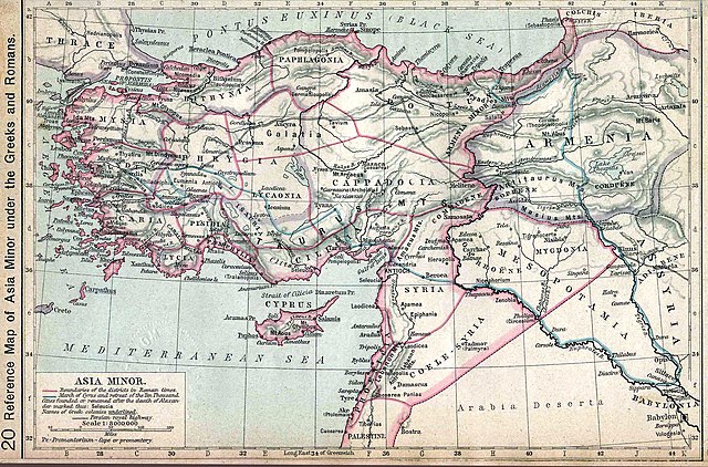
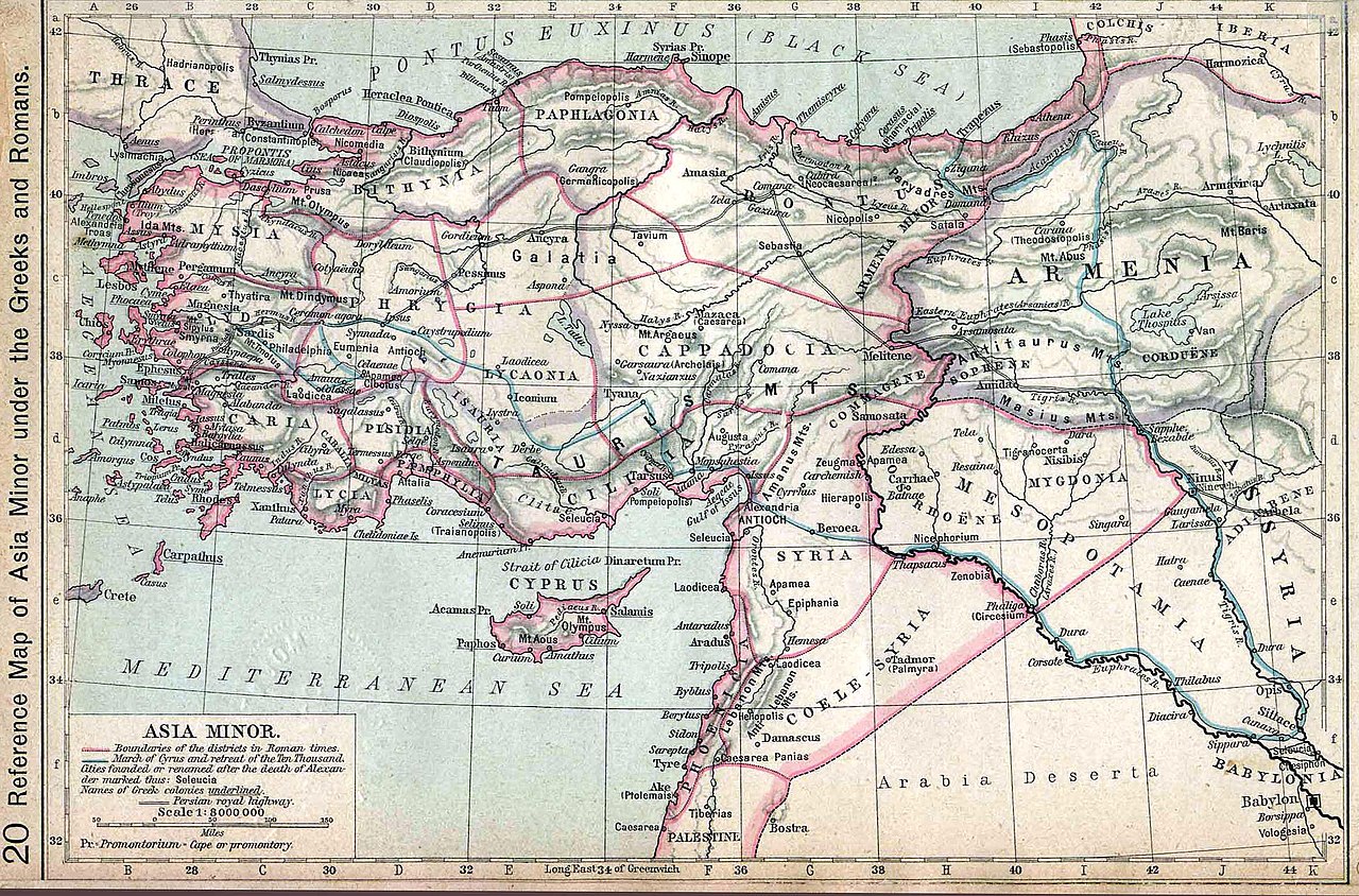
| Danasîn | Map of Asia Minor. Historical Atlas | ||||||||||||||||||||||
| Dîrok | |||||||||||||||||||||||
| Çavkanî | http://www.lib.utexas.edu/maps/historical/history_shepherd_1911.html | ||||||||||||||||||||||
| Xwedî |
|
||||||||||||||||||||||
Lîsans[biguhêre]
|
This work is in the public domain in its country of origin and other countries and areas where the copyright term is the author's life plus 70 years or fewer.
| |
| This file has been identified as being free of known restrictions under copyright law, including all related and neighboring rights. | |
Original upload log[biguhêre]
- 2006-06-07 09:13 Wirya 2350×1547× (406744 bytes) Asia minor under the Greeks and Romans. Map from: [http://www.lib.utexas.edu/maps/], Public Domain {{PD}}
Dîroka daneyê
Ji bo dîtina guhartoya wê demê bişkoka dîrokê bitikîne.
| Dîrok/Katjimêr | Wêneyê biçûk | Mezinahî | Bikarhêner | Şirove | |
|---|---|---|---|---|---|
| niha | 04:44, 13 îlon 2012 | | 2313 x 1525 (1,07 MB) | OgreBot (gotûbêj | beşdarî) | (BOT): Reverting to most recent version before archival |
| 04:44, 13 îlon 2012 |  | 2350 x 1547 (397 KB) | OgreBot (gotûbêj | beşdarî) | (BOT): Uploading old version of file from en.wikipedia; originally uploaded on 2006-06-07 09:13:07 by Wirya | |
| 16:07, 14 kanûna paşîn 2008 |  | 2313 x 1525 (1,07 MB) | Shakko (gotûbêj | beşdarî) | {{Information |Description=Map of Asia Minor. Historical Atlas |Source=http://www.lib.utexas.edu/maps/historical/history_shepherd_1911.html |Date=1911 |Author=en:William R. Shepherd († 1934) |Permission= |other_versions= }} Category:Cappadocia |
Tu nikarî cardin li ser vê dosyeyê binivîsînî.
Bikaranîna pelê
Ev rûpelên li jêr vê dosyeyê bi kar tînin:
Bikaranîna gerdûnî ya pelê
Ev wîkiyên di rêzê de vê pelê bi kar tînin:
- Bikaranîna di als.wikipedia.org de
- Bikaranîna di ar.wikipedia.org de
- Bikaranîna di ba.wikipedia.org de
- Bikaranîna di bg.wikipedia.org de
- Bikaranîna di br.wikipedia.org de
- Bikaranîna di bs.wikipedia.org de
- Bikaranîna di cs.wikipedia.org de
- Bikaranîna di da.wikipedia.org de
- Bikaranîna di de.wikipedia.org de
- Bikaranîna di dsb.wikipedia.org de
- Bikaranîna di el.wikipedia.org de
- Bikaranîna di en.wikipedia.org de
- Bikaranîna di fi.wikipedia.org de
- Bikaranîna di incubator.wikimedia.org de
- Bikaranîna di it.wikipedia.org de
- Bikaranîna di ku.wikipedia.org de
- Bikaranîna di la.wikipedia.org de
- Bikaranîna di pl.wikipedia.org de
- Bikaranîna di pl.wiktionary.org de
- Bikaranîna di pnt.wikipedia.org de
- Bikaranîna di ro.wikipedia.org de
- Bikaranîna di ru.wikipedia.org de
- Bikaranîna di sh.wikipedia.org de
- Bikaranîna di sl.wikipedia.org de
- Bikaranîna di sr.wikipedia.org de
- Bikaranîna di ta.wikipedia.org de
Zêdetir bikaranîna global a vê pelê bibîne.