File:Asie.svg
跳转到导航
跳转到搜索

此SVG文件的PNG预览的大小:788 × 600像素。 其他分辨率:316 × 240像素 | 631 × 480像素 | 1,009 × 768像素 | 1,280 × 974像素 | 2,560 × 1,948像素 | 1,100 × 837像素。
原始文件 (SVG文件,尺寸为1,100 × 837像素,文件大小:567 KB)
说明
说明
添加一行文字以描述该文件所表现的内容
| 描述 |
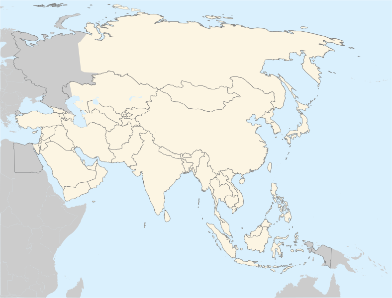
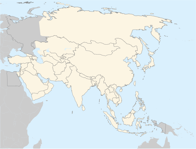
Français : Carte politique de l'Asie
English: Asia political map. The continental boundary to Europe follows the mainstream convention along the Urals, the Ural River, and the crest of the Greater Caucasus.
Português: Mapa politico da Ásia. |
||
| 日期 | |||
| 来源 | http://en.wikipedia.org/wiki/Image:BlankMap-World5.svg | ||
| 作者 | historicair 20:31, 20 November 2006 (UTC) | ||
| 授权 (二次使用本文件) |
|
||
| 其他版本 |
Derivative works of this file: |
文件历史
点击某个日期/时间查看对应时刻的文件。
| 日期/时间 | 缩略图 | 大小 | 用户 | 备注 | |
|---|---|---|---|---|---|
| 当前 | 2022年9月4日 (日) 18:27 | | 1,100 × 837(567 KB) | Рагин1987(留言 | 贡献) | Correction |
| 2022年8月30日 (二) 20:07 |  | 2,560 × 1,948(935 KB) | Рагин1987(留言 | 贡献) | More correct visualization of the dividing line on the territory of the Caucasus Range | |
| 2011年4月13日 (三) 02:37 |  | 1,100 × 837(522 KB) | Gerge(留言 | 贡献) | Reverted to version as of 06:06, 12 April 2011 | |
| 2011年4月12日 (二) 23:11 |  | 1,100 × 837(522 KB) | Green, White and Gold(留言 | 贡献) | Reverted to Dbachmann's version as of 06:52, 11 April 2011 | |
| 2011年4月12日 (二) 06:06 |  | 1,100 × 837(522 KB) | Sigismun(留言 | 贡献) | Reverted to version as of 00:55, 12 April 2011 | |
| 2011年4月12日 (二) 01:00 |  | 1,100 × 837(522 KB) | Green, White and Gold(留言 | 贡献) | Reverted to Dbachmann's version as of 06:52, 11 April 2011 | |
| 2011年4月12日 (二) 00:55 |  | 1,100 × 837(522 KB) | Green, White and Gold(留言 | 贡献) | Reverted to Dbachmann's version as of 06:52, 11 April 2011 | |
| 2011年4月11日 (一) 14:16 |  | 788 × 600(197 KB) | ComtesseDeMingrelie(留言 | 贡献) | Reverted to version as of 14:45, 5 April 2011 | |
| 2011年4月11日 (一) 06:52 |  | 1,100 × 837(522 KB) | Dbachmann(留言 | 贡献) | Reverted to version as of 20:44, 4 April 2011 | |
| 2011年4月5日 (二) 14:45 |  | 788 × 600(197 KB) | ComtesseDeMingrelie(留言 | 贡献) | Reverted to version as of 01:05, 5 April 2011 |
您不可以覆盖此文件。
文件用途
以下26个页面使用本文件:
- Asia
- Commons:Graphic Lab/Map workshop/Archive/2018
- File:Belitung ship routes.svg
- File:China-Manchukuo-map-2.svg
- File:China-Manchukuo-map-fr.png
- File:Cyclemys atripons distribution map.png
- File:Cyclemys enigmatica distribution map.png
- File:Cyclemys fusca distribution map.png
- File:Cyclemys pulchristiata distribution map.png
- File:Die Chinesische Mauer - Karte.jpg
- File:Die Chinesische Mauer - blank-01.jpg
- File:Distribution Map Neofelis nebulosa.svg
- File:Distribution Map Neofelis nebulosa 1994.svg
- File:Distribution Map Neofelis nebulosa IUCN.svg
- File:Distribution Map Neofelis nebulosa Summit.svg
- File:Gemeiner Kurznasenflughund 2016.png
- File:Image-Die Chinesische Mauer - Karte (mit einfachen Linien).jpg
- File:Map of ASEAN member states.svg
- File:Map of the Great Wall of China.jpg
- File:Oriental field week world map.svg
- File:Qualifs AFC 1956.svg
- File:Qualifs AFC 1960.svg
- File:Qualifs AFC 1964.svg
- File:Qualifs AFC 1968.svg
- File:Qualifs AFC 1972.svg
- Template:Asia and Sea
.jpg)
全域文件用途
以下其他wiki使用此文件:
- ar.wikipedia.org上的用途
- az.wikipedia.org上的用途
- bg.wikipedia.org上的用途
- bh.wikipedia.org上的用途
- ca.wikipedia.org上的用途
- cs.wikipedia.org上的用途
- el.wikipedia.org上的用途
- en.wikipedia.org上的用途
- fa.wikipedia.org上的用途
- gl.wikipedia.org上的用途
- hi.wikipedia.org上的用途
- hr.wikipedia.org上的用途
- incubator.wikimedia.org上的用途
- it.wikipedia.org上的用途
查看此文件的更多全域用途。