File:Athens Metro map (2007).svg
Jump to navigation
Jump to search

Size of this PNG preview of this SVG file: 668 × 599 pixels. Other resolutions: 267 × 240 pixels | 535 × 480 pixels | 856 × 768 pixels | 1,141 × 1,024 pixels | 2,282 × 2,048 pixels | 1,560 × 1,400 pixels.
Original file (SVG file, nominally 1,560 × 1,400 pixels, file size: 661 KB)
Captions
Captions
Add a one-line explanation of what this file represents
Summary[edit]
.svg&action=edit§ion=1)
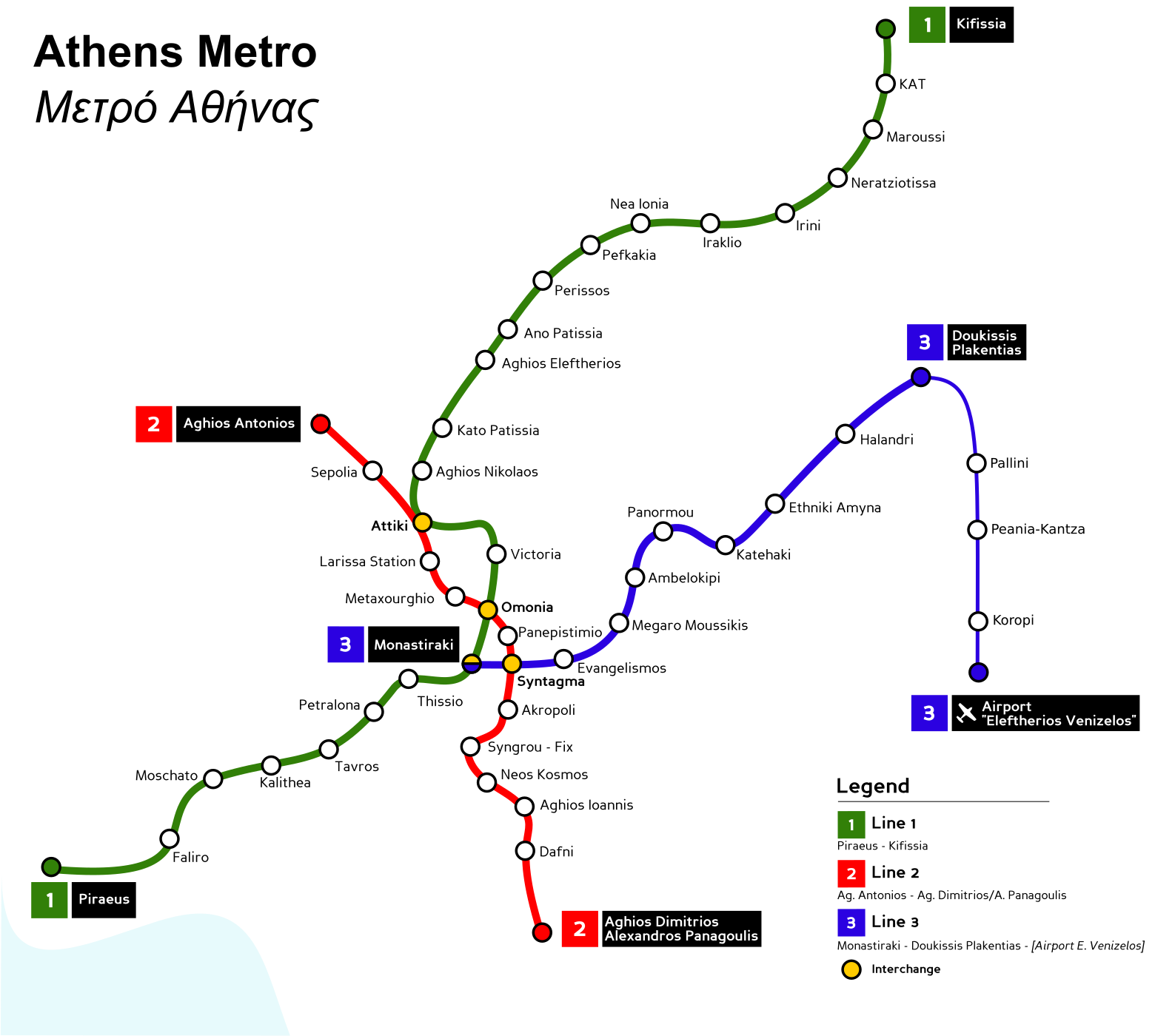
| Description | Athens Metro map. |
| Source | Based on several maps in the Internet. |
| Author | Original map by Mortadelo2005. Updated map that includes the three stations of Pallini, Peania-Kantza, and Koropi by NerdyNSK (Nikolaos S. Karastathis or NSK). |
This W3C-unspecified vector image was created with Inkscape .
Licensing[edit]
.svg&action=edit§ion=2)
I, the copyright holder of this work, hereby publish it under the following licenses:

|
Permission is granted to copy, distribute and/or modify this document under the terms of the GNU Free Documentation License, Version 1.2 or any later version published by the Free Software Foundation; with no Invariant Sections, no Front-Cover Texts, and no Back-Cover Texts. A copy of the license is included in the section entitled GNU Free Documentation License. |
| This file is licensed under the Creative Commons Attribution-Share Alike 3.0 Unported license. | ||
| ||
| This licensing tag was added to this file as part of the GFDL licensing update. |
This file is licensed under the Creative Commons Attribution 2.5 Generic license.
- You are free:
- to share – to copy, distribute and transmit the work
- to remix – to adapt the work
- Under the following conditions:
- attribution – You must give appropriate credit, provide a link to the license, and indicate if changes were made. You may do so in any reasonable manner, but not in any way that suggests the licensor endorses you or your use.
You may select the license of your choice.
The updated map created by User:NerdyNSK that includes the stations of Pallini, Peania-Kantza, and Koropi is also released under the same licences as the original (GFDL 1.2, CC-BY 2.5).
File history
Click on a date/time to view the file as it appeared at that time.
| Date/Time | Thumbnail | Dimensions | User | Comment | |
|---|---|---|---|---|---|
| current | 22:08, 29 July 2007 | | 1,560 × 1,400 (661 KB) | NerdyNSK (talk | contribs) | Updated map to include the stations of Pallini, Peania-Kantza, and Koropi. Edited with Inkscape 0.44 under Debian GNU/Linux 4.0 etch. The original file was released by User:Mortadelo2005 under GFDL 1.2 and CC-BY-2.5. My edits (addition of three sta |
| 14:34, 23 May 2007 |  | 1,560 × 1,400 (658 KB) | Mortadelo2005 (talk | contribs) | {{Information |Description=Athens Metro map. |Source=Based on several maps in the Internet. |Date= |Author=Mortadelo2005 |Permission= |other_versions= }} {{Created with Inkscape}} Category:Rapid transit maps [[Category:Athens Me |
You cannot overwrite this file.
File usage on Commons
The following page uses this file:
- File:Athens Metro.svg (file redirect)
File usage on other wikis
The following other wikis use this file:
- Usage on www.wikidata.org
.svg&oldid=806210820)