File:Athens public transport map future.png
Jump to navigation
Jump to search

Size of this preview: 690 × 599 pixels. Other resolutions: 276 × 240 pixels | 553 × 480 pixels | 884 × 768 pixels | 1,151 × 1,000 pixels.
Original file (1,151 × 1,000 pixels, file size: 123 KB, MIME type: image/png)
Captions
Captions
Add a one-line explanation of what this file represents
Summary
[edit]
| Description |
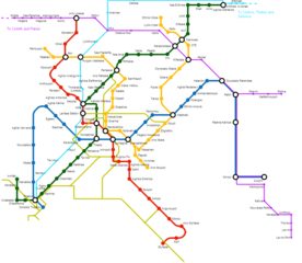
English: Map of Greater Athens complete railway transport, according to current plans. Green, red, blue and orange line is the Athens metro lines as intended to be completed. None of the stations of the orange line yet exists (as of July 2013). Pink and cyan lines represent the suburban lines with future stations and expansions (to Rafina and Lavrio). Thin yellow line represent the current tram network and some plans for future expanions as of 2012. |
| Date | |
| Source | Own work, via Metro Map Creator http://beno.org.uk/metromapcreator/ |
| Author | GianniM |
Licensing
[edit]
I, the copyright holder of this work, hereby publish it under the following license:
This file is licensed under the Creative Commons Attribution-Share Alike 3.0 Unported license.
- You are free:
- to share – to copy, distribute and transmit the work
- to remix – to adapt the work
- Under the following conditions:
- attribution – You must give appropriate credit, provide a link to the license, and indicate if changes were made. You may do so in any reasonable manner, but not in any way that suggests the licensor endorses you or your use.
- share alike – If you remix, transform, or build upon the material, you must distribute your contributions under the same or compatible license as the original.
File history
Click on a date/time to view the file as it appeared at that time.
| Date/Time | Thumbnail | Dimensions | User | Comment | |
|---|---|---|---|---|---|
| current | 09:33, 17 August 2012 | | 1,151 × 1,000 (123 KB) | GianniM (talk | contribs) | cropped |
| 09:28, 17 August 2012 |  | 1,600 × 1,000 (136 KB) | GianniM (talk | contribs) | Pollitehnoupoli -> Kallitehnoupoli, + Anastassi station on Line 1 | |
| 10:33, 12 August 2012 |  | 1,154 × 991 (122 KB) | GianniM (talk | contribs) | More planed expansions of tram network (To Perama, from Tzitzifies to Sygroy through Thiseos, circle line around city historic and business centre) + corrections | |
| 21:53, 11 August 2012 |  | 1,136 × 997 (119 KB) | GianniM (talk | contribs) | plus some other stations on line 4 | |
| 21:45, 11 August 2012 |  | 1,132 × 989 (117 KB) | GianniM (talk | contribs) |
You cannot overwrite this file.
File usage on Commons
There are no pages that use this file.
File usage on other wikis
The following other wikis use this file:
- Usage on en.wikipedia.org