File:Atlanta Central.png
پرش به ناوبری
پرش به جستجو

اندازهٔ این پیشنمایش: ۵۱۴ × ۶۰۰ پیکسل. کیفیتهای دیگر: ۲۰۶ × ۲۴۰ پیکسل | ۵۸۹ × ۶۸۷ پیکسل.
پروندهٔ اصلی (۵۸۹ × ۶۸۷ پیکسل، اندازهٔ پرونده: ۵۰۰ کیلوبایت، نوع MIME پرونده: image/png)
گزینهها
عنوان
شرحی یکخطی از محتوای این فایل اضافه کنید
| توضیح |
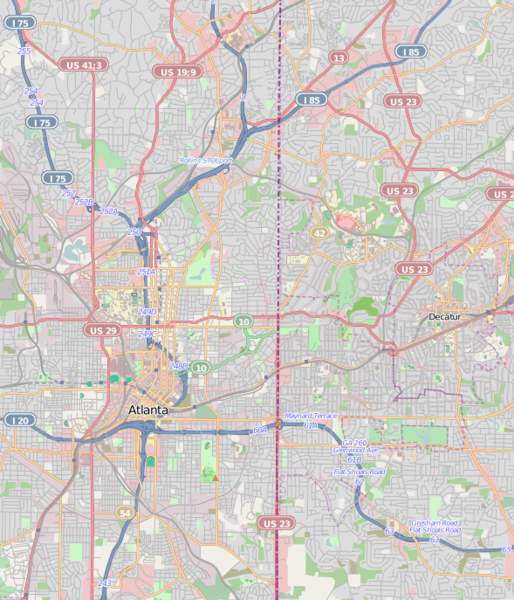
This map was created from OpenStreetMap project data, collected by the community. This map may be incomplete, and may contain errors. Don't rely solely on it for navigation.
|
||||||||||||
| تاریخ | (see file history) | ||||||||||||
| منبع | openstreetmap.org | ||||||||||||
| پدیدآور | OpenStreetMap contributors | ||||||||||||
| اجازهنامه (استفادهٔ مجدد از این پرونده) |
All OpenStreetMap data and maps are Creative Commons "CC-BY-SA 2.0" licensed این پرونده با اجازهنامهٔ کریتیو کامانز Attribution-Share Alike 2.0 عمومی منتشر شده است.
|
||||||||||||
Atlanta Central.png == Usage == * This template can be used without any parameter, but it also supports setting the source=, the date=, the authors=, location= and the other_versions=. If source is not used the parameter name has to be used. * The parameters top=, bottom=, left=, and right= can be used to store the border coordinates of the map. This information can be useful for various mapping templates that are used in various Wikimedia projects. Atlanta Central.pngCategory:Internationalization templates using LangSwitch
تاریخچهٔ پرونده
روی تاریخ/زمانها کلیک کنید تا نسخهٔ مربوط به آن هنگام را ببینید.
| تاریخ/زمان | بندانگشتی | ابعاد | کاربر | توضیح | |
|---|---|---|---|---|---|
| کنونی | ۱۶ مارس ۲۰۱۱، ساعت ۲۲:۴۲ | | ۵۸۹ در ۶۸۷ (۵۰۰ کیلوبایت) | Keizers (بحث | مشارکتها) | updated |
| ۱۶ مارس ۲۰۱۱، ساعت ۱۷:۳۷ |  | ۵۸۰ در ۷۰۷ (۶۷۱ کیلوبایت) | Keizers (بحث | مشارکتها) | ({{Information |Description={{LangSwitch |de=Diese Karte {{#if: {{{location|}}}|von {{{location}}} }} entstammt dem offenen OpenStreetMap Projekt, erstellt von der Community. <small>Diese Karte kann unvollständig sein oder Fehler enthalten. Verlasse dich |
شما نمیتوانید این پرونده را رونویسی کنید.
کاربرد پرونده
صفحهٔ زیر از این تصویر استفاده میکند:
کاربرد سراسری پرونده
ویکیهای دیگر زیر از این پرونده استفاده میکنند:
- کاربرد در ar.wikipedia.org
- کاربرد در arz.wikipedia.org
- کاربرد در ban.wikipedia.org
- کاربرد در bn.wikipedia.org
- کاربرد در ceb.wikipedia.org
- کاربرد در en.wikipedia.org
- Gresham Park, Georgia
- North Decatur, Georgia
- North Druid Hills, Georgia
- Promenade II
- Tower Square (Atlanta)
- State Farm Arena
- Midtown Atlanta
- Bobby Dodd Stadium
- Atlanta Cyclorama & Civil War Museum
- Georgia State Capitol
- Fernbank Science Center
- Inman Park
- Bankhead, Atlanta
- List of tallest buildings in Atlanta
- Grant Park, Atlanta
- Martin Luther King Jr. National Historical Park
- Atlanta History Center
- BeltLine
- Oakland Cemetery (Atlanta)
- Episcopal Cathedral of Saint Philip (Atlanta)
- Candler Park
- Georgia Governor's Mansion
- Sweet Auburn
- Atlanta Civic Center
- Techwood Homes
- West End, Atlanta
- Fairlie–Poplar, Atlanta
- Cabbagetown, Atlanta
- Druid Hills Historic District (Atlanta, Georgia)
- Reynoldstown, Atlanta
- 1180 Peachtree
- Atlanta City Hall
- Westside Park
- Ansley Park
- Rhodes Hall
- Castleberry Hill
- Mechanicsville, Atlanta
- Mary Mac's Tea Room
- Center for Puppetry Arts
- Brookwood Hills
- The Texas (locomotive)
- Sweet Auburn Curb Market
- Georgia Institute of Technology Historic District
نمایش استفادههای سراسری از این پرونده.