File:Atlantic Forest WWF.png
Jump to navigation
Jump to search

Size of this preview: 595 × 599 pixels. Other resolutions: 238 × 240 pixels | 477 × 480 pixels | 763 × 768 pixels | 1,017 × 1,024 pixels | 1,776 × 1,788 pixels.
Original file (1,776 × 1,788 pixels, file size: 4.35 MB, MIME type: image/png)
Captions
Captions
Add a one-line explanation of what this file represents
Summary
[edit]
| Description |
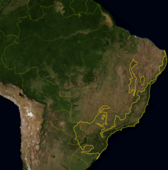
English: This is a map location of the Atlantic Forest. The yellow line encloses Atlantic forest as delineated by the World Wide Fund for Nature. I, Miguelrangeljr, made it using NASA Blue Marble imagery.
Português: Este mapa mostra a localização da ecorregiao da Mata Atlântica. A linha amarela grossa delimita essa ecorregião como definida pelo WWF. Eu,Miguelrangeljr, fiz isso usando uma mapa de satélite da NASA e me baseei no livro Visão da Biodiversidade - Floresta Atlântica do Alto Paraná para desenhar a linha, usando o Paint. |
|||||
| Date | ||||||
| Source | NASA plus my editions by mysefl | |||||
| Author | NASA and Miguelrangeljr | |||||
| Permission (Reusing this file) |
|
Licensing
[edit]
| This file is in the public domain in the United States because it was solely created by NASA. NASA copyright policy states that "NASA material is not protected by copyright unless noted". (See Template:PD-USGov, NASA copyright policy page or JPL Image Use Policy.) | ||
 |
Warnings:
|
File history
Click on a date/time to view the file as it appeared at that time.
| Date/Time | Thumbnail | Dimensions | User | Comment | |
|---|---|---|---|---|---|
| current | 02:12, 17 May 2012 | | 1,776 × 1,788 (4.35 MB) | Miguelrangeljr (talk | contribs) | {{Information |Description ={{en|1=This is a map location of the Atlantic Forest. The yellow line encloses Atlantic forest as delineated by the World Wide Fund for Nature. I, Miguelrangeljr, made it using NASA Blue Marble imagery.}} {{pt|1=E... |
You cannot overwrite this file.
File usage on Commons
The following page uses this file:
File usage on other wikis
The following other wikis use this file:
- Usage on ban.wikipedia.org
- Usage on eo.wikipedia.org