File:Atlas zur Geschichte Dresdens Tafel 30.jpg
Jump to navigation
Jump to search

Size of this preview: 736 × 599 pixels. Other resolutions: 295 × 240 pixels | 589 × 480 pixels | 943 × 768 pixels | 1,257 × 1,024 pixels | 2,515 × 2,048 pixels | 15,006 × 12,222 pixels.
Original file (15,006 × 12,222 pixels, file size: 16.16 MB, MIME type: image/jpeg)
Captions
Captions
Add a one-line explanation of what this file represents
Summary
[edit]| Description |
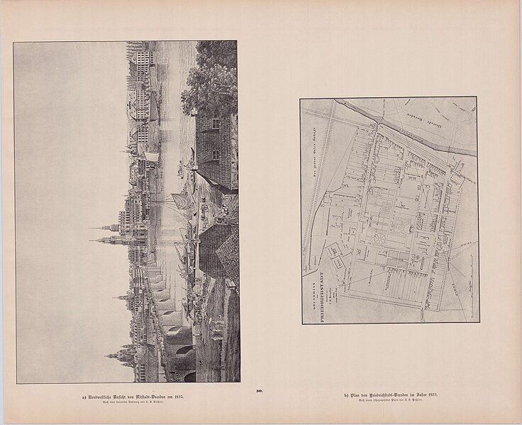
Deutsch: Atlas zur Geschichte Dresdens. Tafel 30 – a) Nordwestliche Ansicht von Altstadt-Dresden um 1825. b) Plan von Friedrichstadt-Dresden im Jahre 1832. Veröffentlichung des Vereins für Geschichte Dresdens. |
| Date | |
| Source | Self-scanned |
| Author | Herausgeber: Otto Richter (1852–1922) |
| Other versions |
.jpg)
.jpg)
Licensing
[edit]
|
This work is in the public domain in its country of origin and other countries and areas where the copyright term is the author's life plus 70 years or fewer. This work is in the public domain in the United States because it was published (or registered with the U.S. Copyright Office) before January 1, 1929. | |
| This file has been identified as being free of known restrictions under copyright law, including all related and neighboring rights. | |
File history
Click on a date/time to view the file as it appeared at that time.
| Date/Time | Thumbnail | Dimensions | User | Comment | |
|---|---|---|---|---|---|
| current | 17:34, 5 March 2023 | | 15,006 × 12,222 (16.16 MB) | A. Wagner (talk | contribs) | == {{int:filedesc}} == {{Information |Description= {{de|''Atlas zur Geschichte Dresdens.'' Tafel 30 – a) Nordwestliche Ansicht von Altstadt-Dresden um 1825. b) Plan von Friedrichstadt-Dresden im Jahre 1832.<br />Veröffentlichung des Vereins für Geschichte Dresdens.}} |Source={{self-scanned}} |Date=1898 |Author= Herausgeber: Otto Richter (1852–1922) |Permission= |other_versions= }} == {{int:license-header}} == {{PD-old-70-1923}} Category:Atlas zur Geschichte Dresdens |
You cannot overwrite this file.
File usage on Commons
The following 4 pages use this file: