File:Austrian Netherlands 1789.svg
Перайсьці да навігацыі
Перайсьці да пошуку

Памер гэтага PNG-прагляду для SVG-файлу: 450 × 456 піксэлаў. Іншыя разрозьненьні: 237 × 240 піксэлаў | 474 × 480 піксэлаў | 758 × 768 піксэлаў | 1011 × 1024 піксэлаў | 2021 × 2048 піксэлаў.
Арыгінальны файл (SVG-файл, намінальна 450 × 456 піксэлаў, памер файла: 858 кб)
Подпісы
Подпісы
Дадайце аднарадковае тлумачэньне, што зь сябе ўяўляе гэты файл
Апісаньне
[рэдагаваць]


.svg)
.svg)
.svg)
.svg)
.svg)


.svg)
.svg)
.svg)


.png)
.png)


.svg)


.svg)

.svg)


.svg)
.svg)
.svg)
.svg)


.svg)
.png)


.svg)


.svg)
.svg)


.svg)


.svg)


.svg)
.svg)
.svg)
.svg)
.svg)
.svg)
.svg)
_cropped.svg)
.svg)
.svg)
.svg)
.svg)
.svg)
.svg)
.svg)
.svg)
.svg)
.svg)
.svg)
.svg)
.svg)
.svg)
.svg)
.svg)
.svg)
.svg)
.svg)
.svg)
.svg)
.svg)
.svg)
.svg)
.svg)
.svg)
.svg)
.svg)
.svg)
.svg)
.svg)
.svg)
.svg)
.svg)
.svg)
.svg)
.svg)
.svg)
.svg)
.svg)
.svg)
.svg)
.svg)
.svg)
.svg)
Ліцэнзія
[рэдагаваць]
Я, уладальнік аўтарскіх правоў на гэтую працу, добраахвотна публікую яе на ўмовах наступнай ліцэнзіі:
Гэты файл ліцэнзаваны згодна з умовамі ліцэнзіі Creative Commons Attribution-Share Alike 3.0 Unported.
- Вы можаце свабодна:
- дзяліцца – капіяваць, распаўсюджваць і перадаваць гэты твор
- ствараць вытворныя творы – адаптаваць твор
- Пры выкананьні наступных умоваў:
- пазначэньне аўтарства – Вы мусіце пазначыць аўтарства, падаць спасылку на ліцэнзію і пазначыць, ці былі зробленыя зьмены. Вы можаце зрабіць гэта любым разумным спосабам, але не такім чынам, каб склалася ўражаньне, што ліцэнзіят падтрымлівае вас ці выкарыстаньне вамі гэтага твору.
- распаўсюджваць на тых жа ўмовах – Калі вы зьмяняеце, трансфармуеце ці грунтуецеся на гэтым матэрыяле, вы мусіце распаўсюджваць ваш унёсак паводле той жа ці сумяшчальнай ліцэнзіі, што і арыгінал.
Арыгінальны журнал загрузак
[рэдагаваць]
This image is a derivative work of the following images:
- File:Europe_1789.svg licensed with Cc-by-sa-3.0
- 2013-04-14T03:44:26Z Alphathon 450x456 (858577 Bytes) Corrected some errors in northern Italy
- 2013-04-14T01:38:01Z Alphathon 450x456 (853881 Bytes) tweaked again
- 2013-04-14T01:36:10Z Alphathon 450x456 (853881 Bytes) Tweaked Holy Roman Empire border style
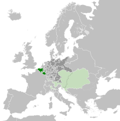
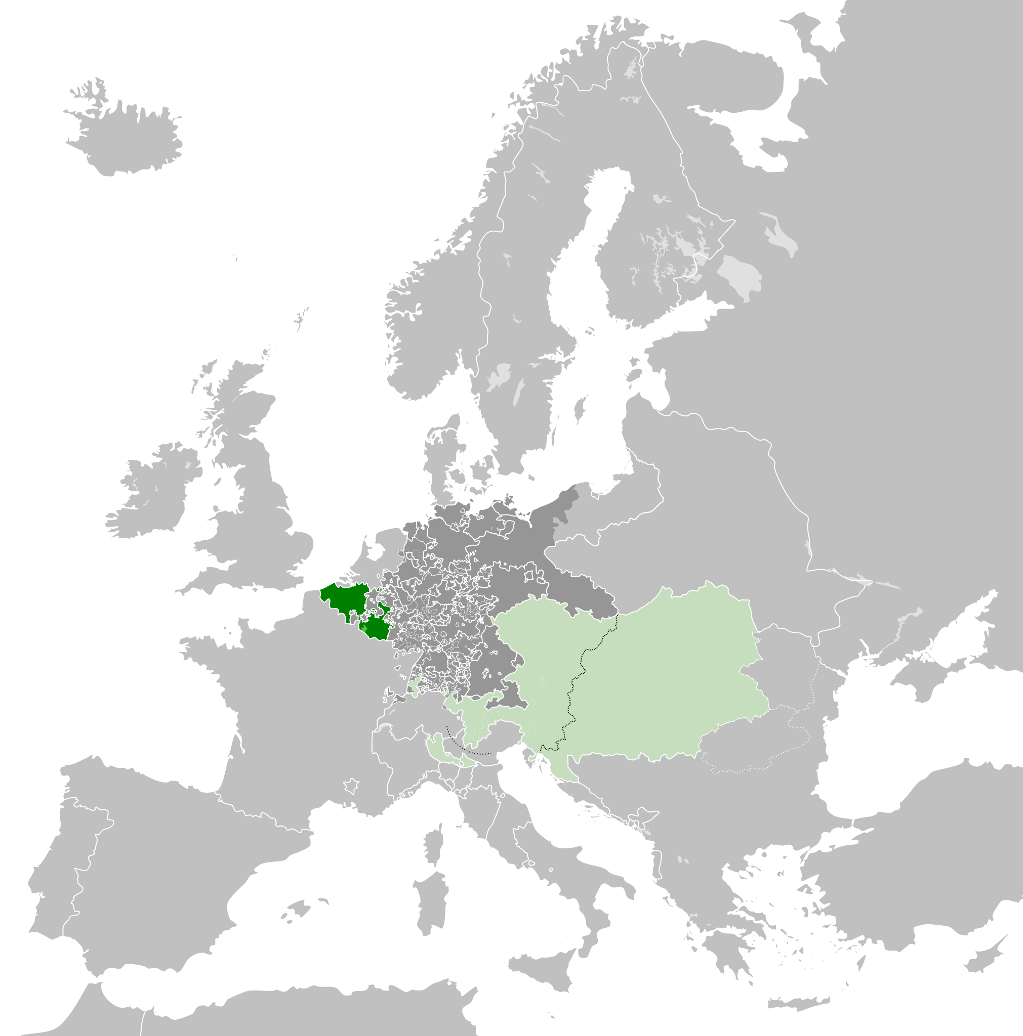
- 2013-04-14T01:33:26Z Alphathon 450x456 (853857 Bytes) == {{int:filedesc}} == {{Information |Description={{en|A blank Map of Europe circa 1789. This map also includes a border for the [[:en:Holy Roman Empire|Holy Roman Empire]]. Since there are so many small German states, they h
Загружана з дапамогай derivativeFX
Гісторыя файла
Націсьніце на дату/час, каб паглядзець, як тады выглядаў файл.
| Дата і час | Мініятура | Памеры | Удзельнік | Камэнтар | |
|---|---|---|---|---|---|
| цяперашняя | 07:38, 17 кастрычніка 2021 | | 450 × 456 (858 кб) | Fenn-O-maniC (Абмеркаваньне | унёсак) | Wrong file |
| 07:38, 17 кастрычніка 2021 |  | 450 × 456 (800 кб) | Fenn-O-maniC (Абмеркаваньне | унёсак) | Fixed the Russo-Swedish border to match the Treaty of Åbo of 1743 | |
| 07:36, 17 кастрычніка 2021 |  | 450 × 456 (858 кб) | Fenn-O-maniC (Абмеркаваньне | унёсак) | Fixed the Russo-Swedish border to match the Treaty of Åbo of 1743 | |
| 20:34, 18 красавіка 2013 |  | 450 × 456 (878 кб) | Alphathon (Абмеркаваньне | унёсак) | Style change | |
| 18:34, 18 красавіка 2013 |  | 450 × 456 (857 кб) | Alphathon (Абмеркаваньне | унёсак) | Various fixes | |
| 20:31, 15 красавіка 2013 |  | 450 × 456 (854 кб) | Alphathon (Абмеркаваньне | унёсак) | Corrected Scandinavian borders | |
| 23:18, 14 красавіка 2013 |  | 450 × 456 (839 кб) | Alphathon (Абмеркаваньне | унёсак) | Changed colour of the remainder of the Habsburg Monarchy | |
| 13:29, 14 красавіка 2013 |  | 450 × 456 (839 кб) | Alphathon (Абмеркаваньне | унёсак) | == {{int:filedesc}} == {{Information |Description={{en|A map of the Austrian Netherlands within the Habsburg Monarchy, the Holy Roman Empire and Europe circa 1789.}}{{de|Eine Landkarte die [[:de:Öste... |
Вы ня можаце перазапісаць гэты файл.
Выкарыстаньне файла
Наступныя старонкі выкарыстоўваюць гэты файл:
.svg)
Глябальнае выкарыстаньне файла
Гэты файл выкарыстоўваецца ў наступных вікі:
- Выкарыстаньне ў ar.wikipedia.org
- Выкарыстаньне ў ast.wikipedia.org
- Выкарыстаньне ў bg.wikipedia.org
- Выкарыстаньне ў cs.wikipedia.org
- Выкарыстаньне ў en.wikipedia.org
- Выкарыстаньне ў eo.wikipedia.org
- Выкарыстаньне ў es.wikipedia.org
- Выкарыстаньне ў et.wikipedia.org
- Выкарыстаньне ў eu.wikipedia.org
- Выкарыстаньне ў fa.wikipedia.org
- Выкарыстаньне ў fi.wikipedia.org
- Выкарыстаньне ў fr.wikipedia.org
- Выкарыстаньне ў gl.wikipedia.org
- Выкарыстаньне ў he.wikipedia.org
- Выкарыстаньне ў id.wikipedia.org
- Выкарыстаньне ў is.wikipedia.org
- Выкарыстаньне ў it.wikipedia.org
- Выкарыстаньне ў ja.wikipedia.org
- Выкарыстаньне ў ko.wikipedia.org
- Выкарыстаньне ў lv.wikipedia.org
- Выкарыстаньне ў mk.wikipedia.org
- Выкарыстаньне ў pt.wikipedia.org
- Выкарыстаньне ў sl.wikipedia.org
- Выкарыстаньне ў th.wikipedia.org
- Выкарыстаньне ў tr.wikipedia.org
- Выкарыстаньне ў uk.wikipedia.org
- Выкарыстаньне ў vi.wikipedia.org
- Выкарыстаньне ў www.wikidata.org
- Выкарыстаньне ў zh.wikipedia.org