File:Awyrlun o Bontcysyllte - Pontcysyllte Aqueduct, part of a UNESCO World Heritage Site in Wales 58.jpg
Ir a la navegación
Ir a la búsqueda

Tamaño de esta previsualización: 800 × 450 píxeles. Otras resoluciones: 320 × 180 píxeles | 640 × 360 píxeles | 1024 × 576 píxeles | 1280 × 720 píxeles | 1920 × 1080 píxeles.
Archivo original (1920 × 1080 píxeles; tamaño de archivo: 2,14 MB; tipo MIME: image/jpeg)
Leyendas
Leyendas
Añade una explicación corta acerca de lo que representa este archivo
Pontcysyllte Aqueduct, part of a UNESCO World Heritage Site in Wales
Resumen
[editar]
| Descripción |
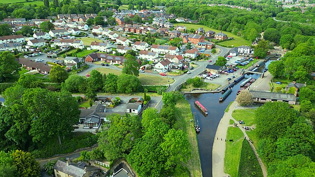
Cymraeg: Awyrlun o Bontcysyllte - traphont i gychod, sy'n dwyn Camlas Llangollen dros ddyffryn Afon Dyfrdwy rhwng pentrefi Trefor a Froncysyllte.
Cwblhawyd adeiladu'r bont yn 1805, ond hyd heddiw, hon yw'r draphont ddwr hiraf ac uchaf yng ngwledydd Prydain, ac mae'n adeiladwaith sydd wedi ei restru ar Raddfa I Adeiladau Rhestredig. Yn ogystal mae'n un o Safleoedd Treftadaeth y Byd.
English: Pontcysyllte Aqueduct, part of a UNESCO World Heritage Site in Wales. It is a navigable aqueduct that carries the Llangollen Canal across the River Dee in the Vale of Llangollen in northeast Wales.
'Cysyllte' is the Welsh word for 'connection', as the bridge connects the canal on both sides. |
| Fecha | |
| Fuente | Trabajo propio |
| Autor | Llywelyn2000 |
| Posición de la cámara | | Ubicación de esta y otras imágenes en: OpenStreetMap |
|---|
Licencia
[editar]
Yo, el titular de los derechos de autor de esta obra, la publico en los términos de la siguiente licencia:
Este archivo está disponible bajo la licencia Creative Commons Attribution-Share Alike 4.0 International.
- Eres libre:
- de compartir – de copiar, distribuir y transmitir el trabajo
- de remezclar – de adaptar el trabajo
- Bajo las siguientes condiciones:
- atribución – Debes otorgar el crédito correspondiente, proporcionar un enlace a la licencia e indicar si realizaste algún cambio. Puedes hacerlo de cualquier manera razonable pero no de manera que sugiera que el licenciante te respalda a ti o al uso que hagas del trabajo.
- compartir igual – En caso de mezclar, transformar o modificar este trabajo, deberás distribuir el trabajo resultante bajo la misma licencia o una compatible como el original.
Esta imagen fue subida como parte de Wiki Loves Earth 2023.
|
 |
Historial del archivo
Haz clic sobre una fecha y hora para ver el archivo tal como apareció en ese momento.
| Fecha y hora | Miniatura | Dimensiones | Usuario | Comentario | |
|---|---|---|---|---|---|
| actual | 15:08 17 jun 2023 | | 1920 × 1080 (2,14 MB) | Llywelyn2000 (discusión | contribs.) | Uploaded own work with UploadWizard |
No puedes sobrescribir este archivo.
Usos del archivo
La siguiente página usa este archivo:
Uso global del archivo
Las wikis siguientes utilizan este archivo:
- Uso en ca.wikipedia.org
- Uso en cy.wikipedia.org
- Uso en es.wikipedia.org
- Uso en eu.wikipedia.org
- Uso en www.wikidata.org