File:Azerbaijan topographic map-fr.svg
跳转到导航
跳转到搜索

此SVG文件的PNG预览的大小:757 × 502像素。 其他分辨率:320 × 212像素 | 640 × 424像素 | 1,024 × 679像素 | 1,280 × 849像素 | 2,560 × 1,698像素。
原始文件 (SVG文件,尺寸为757 × 502像素,文件大小:3.07 MB)
说明
说明
添加一行文字以描述该文件所表现的内容
摘要
[编辑]| 描述 |
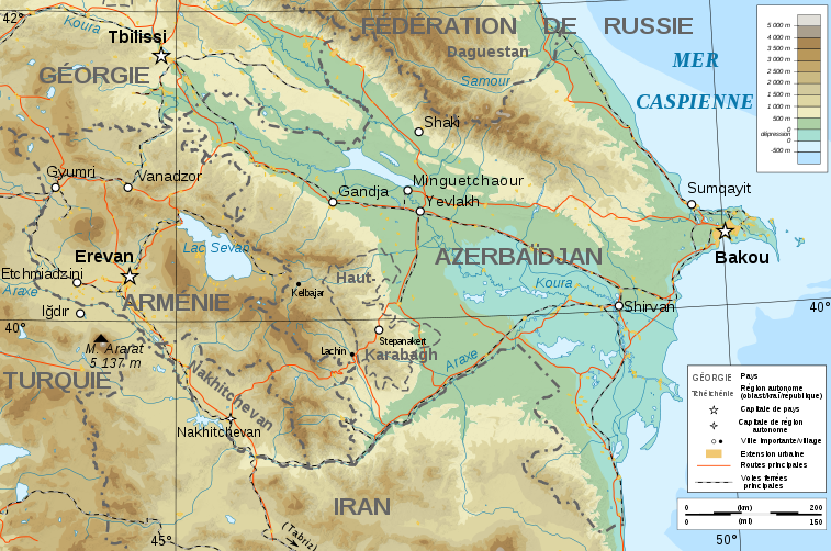
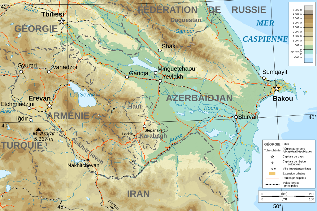
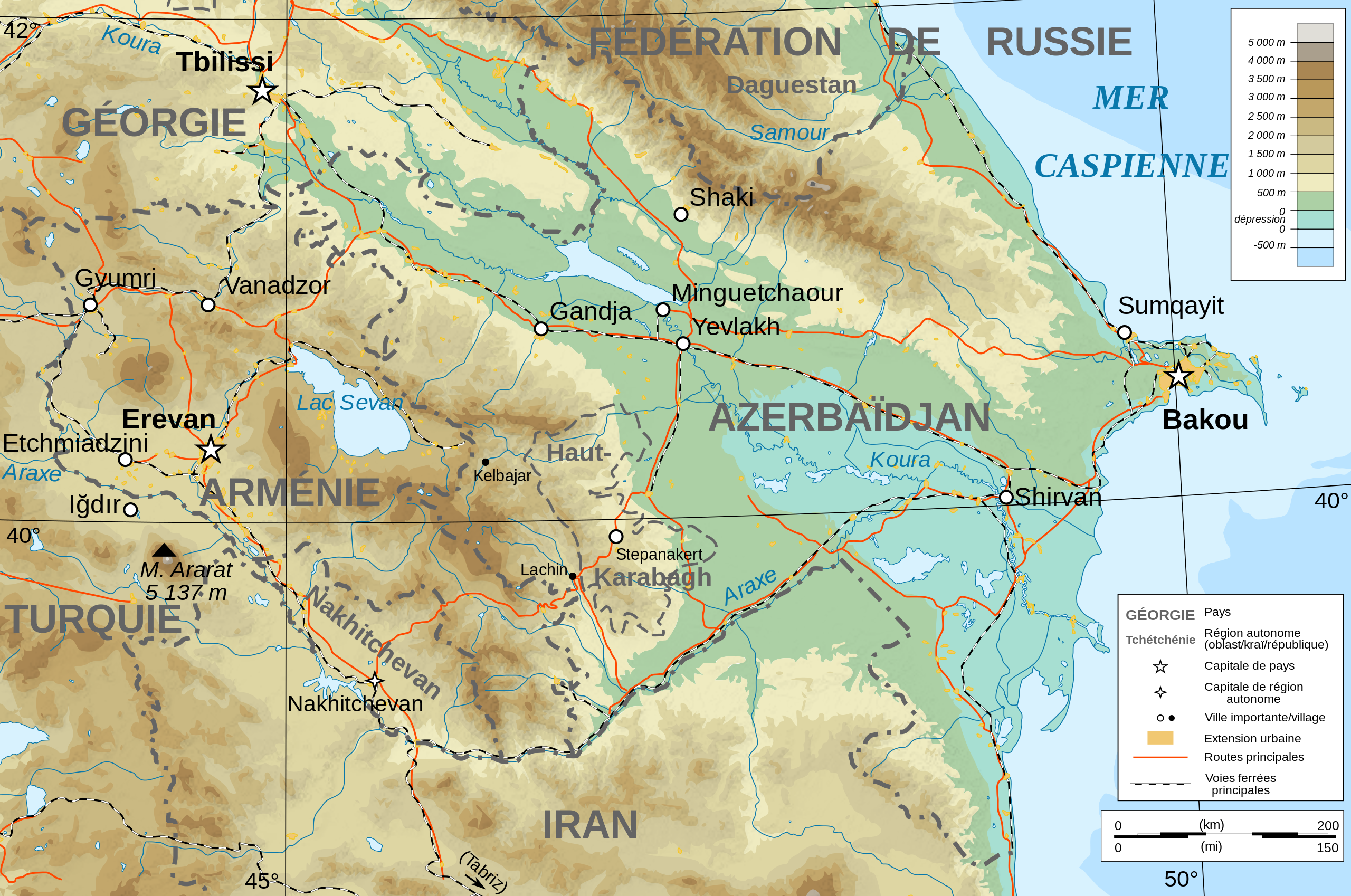
Français : Carte topographique en français de l'Azerbaïdjan et de l'Arménie, avec le Haut-Karabagh en tant que région autonome. |
| 日期 | |
| 来源 |
English: Own work ; Topographic data from the NASA Shuttle Radar Topography Mission (SRTM3 v.2) (public domain) edited with 3DEM, reprojected in UTM with GDAL (GDAL), and vectorized with Inkscape ; UTM projection ; WGS84 datum ; shaded relief (composite image of N-W, W and N lightning positions) ; Reference used for the additional data : * Rivers, cities, railroads, routes, bathymetry : Demis add-on for World Wind (see the approval e-mail and the Demis forum) ; * Borders and coast : World data bank II ; Note : The shaded relief is a raster image embedded in the SVG file. Français : Création personnelle ; Données topographiques de la NASA Shuttle Radar Topography Mission (SRTM3 v.2) (domaine public) éditées avec 3DEM, reprojetées en UTM avec GDAL et vectorisées avec Inkscape ; projection UTM ; WGS84 datum ; relief ombré (image composite d'éclairages du N-O, O et N) ; Références utilisées pour les données complémentaires : * Rivières, villes, chemins de fers, routes, bathymétrie : Demis add-on for World Wind (cf. l'e-mail d'approbation de Demis et le Demis forum) ; * Frontières et côtes : World data bank II ; Note : Le relief ombré est une image bitmap embarquée dans le fichier SVG. |
| 作者 | Bourrichon - fr:Bourrichon) |
| 授权 (二次使用本文件) |
GFDL / Attribution and Share-Alike required |
| 其他版本 |
|
| SVG开发 |


许可协议
[编辑]
我,本作品著作权人,特此采用以下许可协议发表本作品:

|
已授权您依据自由软件基金会发行的无固定段落及封面封底文字(Invariant Sections, Front-Cover Texts, and Back-Cover Texts)的GNU自由文件许可协议1.2版或任意后续版本的条款,复制、传播和/或修改本文件。该协议的副本请见“GNU Free Documentation License”。 |
- 您可以自由地:
- 共享 – 复制、发行并传播本作品
- 修改 – 改编作品
- 惟须遵守下列条件:
- 署名 – 您必须对作品进行署名,提供授权条款的链接,并说明是否对原始内容进行了更改。您可以用任何合理的方式来署名,但不得以任何方式表明许可人认可您或您的使用。
- 相同方式共享 – 如果您再混合、转换或者基于本作品进行创作,您必须以与原先许可协议相同或相兼容的许可协议分发您贡献的作品。
您可以选择您需要的许可协议。
文件历史
点击某个日期/时间查看对应时刻的文件。
| 日期/时间 | 缩略图 | 大小 | 用户 | 备注 | |
|---|---|---|---|---|---|
| 当前 | 2008年11月10日 (一) 18:12 | | 757 × 502(3.07 MB) | Bourrichon(留言 | 贡献) | + corr légende |
| 2008年11月10日 (一) 18:07 |  | 757 × 502(3.07 MB) | Bourrichon(留言 | 贡献) | + Iğdır | |
| 2008年11月10日 (一) 17:45 |  | 757 × 502(3.06 MB) | Bourrichon(留言 | 贡献) | + cities | |
| 2008年11月9日 (日) 17:25 |  | 757 × 502(3.06 MB) | Bourrichon(留言 | 贡献) | ||
| 2008年11月8日 (六) 16:36 |  | 757 × 502(3.06 MB) | Bourrichon(留言 | 贡献) | == Summary == {{Information |Description={{de|Topographische Karte von Aserbaidschan und Armenien, französische Version}}{{en|Topographic map in French of Azerbaijan and Armenia}}{ |
您不可以覆盖此文件。
文件用途
以下15个页面使用本文件:
- File:Azerbaijan topographic map-de.svg
- File:Caucasus by night.svg
- File:Caucasus hydro map-fr.svg
- File:Caucasus mountain range map-fr.svg
- File:Caucasus topo map-blank.jpg
- File:Caucasus topo map-blank.svg
- File:Caucasus topographic map-ar.png
- File:Caucasus topographic map-av.png
- File:Caucasus topographic map-fr.png
- File:Caucasus topographic map-fr.svg
- File:Chechnya topographic map-fr.svg
- File:Georgia administrative map-fr.svg
- File:Georgia topographic map-fr.svg
- File:North Caucasus topographic map-es.svg
- File:North Caucasus topographic map-fr.svg
全域文件用途
以下其他wiki使用此文件:
- de.wikibooks.org上的用途
- en.wikipedia.org上的用途
- eo.wikipedia.org上的用途
- fi.wikipedia.org上的用途
- fr.wikipedia.org上的用途
- pcd.wikipedia.org上的用途
- ro.wikipedia.org上的用途
- to.wikipedia.org上的用途