File:B-C-E-P claims and reivindications.jpg
Aller à la navigation
Aller à la recherche

Pas de plus haute résolution disponible.
B-C-E-P_claims_and_reivindications.jpg (373 × 261 pixels, taille du fichier : 53 kio, type MIME : image/jpeg)
Légendes
Légendes
Ajoutez en une ligne la description de ce que représente ce fichier
Description[modifier]
| Description |
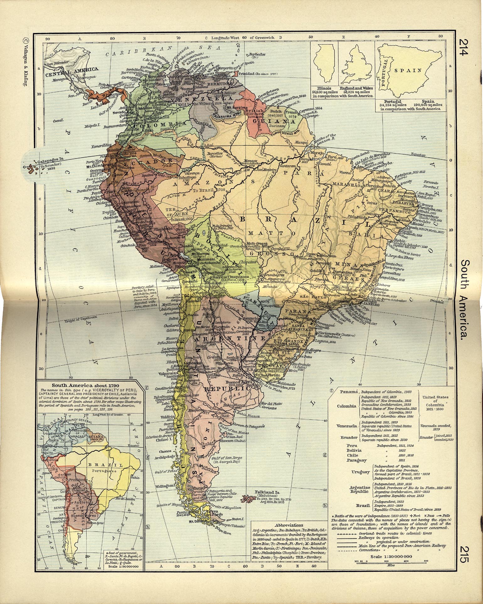
English: This image is a copy from South america.jpg c-241-215 from the Historical Atlas by William R. Shepherd of the Perry-Castañeda Library (PCL) of the University of Texas at Austin, with enhanced colors. |
||||||||||||||||||||||
| Date | |||||||||||||||||||||||
| Source | Historical Atlas | ||||||||||||||||||||||
| Auteur |
|
||||||||||||||||||||||
Conditions d’utilisation[modifier]
Ce document est dans le domaine public aux États-Unis. Ceci s'applique aux travaux des États-Unis où le copyright a expiré, souvent parce que sa première publication s'est produite avant le 1er janvier 1929. Voir cette page pour davantage d'explication.
|
 | |
 |
Cette image peut ne pas être dans le domaine public en dehors des États-Unis (ceci s'applique particulièrement au Canada, en Chine (pas Hong Kong, Macao, ni Taïwan), en Allemagne ou en Suisse). Le créateur et l'année de la publication sont l'information essentielle et doivent être fournis.
|
Historique du fichier
Cliquer sur une date et heure pour voir le fichier tel qu'il était à ce moment-là.
| Date et heure | Vignette | Dimensions | Utilisateur | Commentaire | |
|---|---|---|---|---|---|
| actuel | 21 août 2008 à 15:20 | | 373 × 261 (53 kio) | Milenioscuro (d | contributions) | {{Information |Description={{en|1=This image is a copy from [http://www.lib.utexas.edu/maps/historical/shepherd_1911/shepherd-c-214-215.jpg South america.jpg c-241-215] from the [http://www.lib.utexas.edu/maps/historical/history_shepherd_1911.html Histori |
Vous ne pouvez pas remplacer ce fichier.
Utilisations locales du fichier
Aucune page n’utilise ce fichier.
Utilisations du fichier sur d’autres wikis
Les autres wikis suivants utilisent ce fichier :
- Utilisation sur ar.wikipedia.org
- Utilisation sur ast.wikipedia.org
- Utilisation sur ca.wikipedia.org
- Utilisation sur en.wikipedia.org
- Utilisation sur es.wikipedia.org
- Conflicto limítrofe entre el Ecuador y el Perú
- Historia territorial del Perú
- Imperio del Brasil
- Guerra colombo-peruana
- Historia territorial del Brasil
- Frontera entre Brasil y Colombia
- Frontera entre Colombia y Ecuador
- Guerra peruano-ecuatoriana (1858-1860)
- Tensión peruano-ecuatoriana de 1910
- Anexo:Guerras del Perú
- Línea Apaporis-Tabatinga
- Conflicto limítrofe entre el Perú y Colombia
- Colombianización de Leticia, Putumayo y Caquetá
- Utilisation sur fa.wikipedia.org
- Utilisation sur fr.wikipedia.org
- Utilisation sur pt.wikipedia.org
- Utilisation sur ru.wikipedia.org
- Utilisation sur www.wikidata.org
Métadonnées
Catégories :
- English-language maps showing history
- Maps of the history of Ecuador
- Ecuador-Peru border disputes
- Atlas of South America
- Old maps of borders of Colombia
- Maps of borders of Ecuador
- Maps of borders of Brazil
- Maps of the border between Brazil and Colombia
- Relations of Brazil and Ecuador
- Relations of Brazil and Peru
- Maps of the border between Colombia and Ecuador
- Maps of the border between Colombia and Peru