File:BC Elevation (no legend).svg
Jump to navigation
Jump to search

Size of this PNG preview of this SVG file: 699 × 599 pixels. Other resolutions: 280 × 240 pixels | 560 × 480 pixels | 896 × 768 pixels | 1,194 × 1,024 pixels | 2,389 × 2,048 pixels | 750 × 643 pixels.
Original file (SVG file, nominally 750 × 643 pixels, file size: 4.21 MB)
Captions
Captions
Add a one-line explanation of what this file represents
Summary[edit]
.svg&action=edit§ion=1)
| Description |
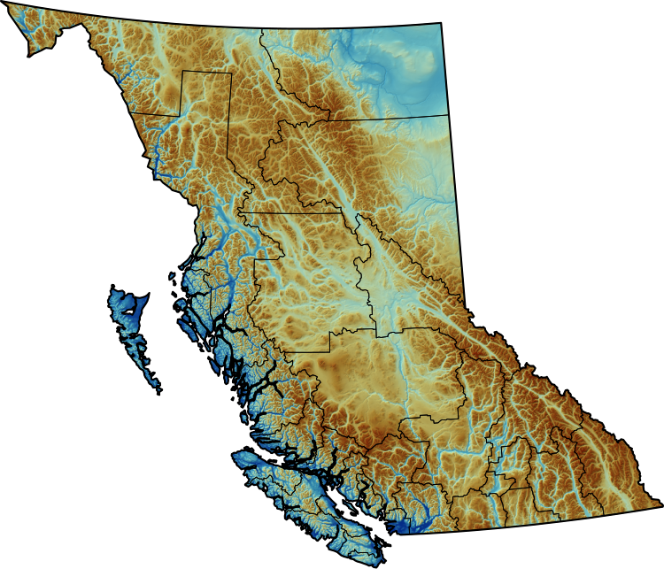
English: Elevation of British Columbia, with relief shading and regional district boundaries shown. Source: GMTED2010, 7.5 seconds. Projection: EPSG:3153. Sorry, my relief shading algorithm is a trade secret, I encourage you to try and reverse-engineer it :^) |
| Date | |
| Source | Own work |
| Author | Awmcphee |
Licensing[edit]
.svg&action=edit§ion=2)
I, the copyright holder of this work, hereby publish it under the following license:
| This file is made available under the Creative Commons CC0 1.0 Universal Public Domain Dedication. | |
| The person who associated a work with this deed has dedicated the work to the public domain by waiving all of their rights to the work worldwide under copyright law, including all related and neighboring rights, to the extent allowed by law. You can copy, modify, distribute and perform the work, even for commercial purposes, all without asking permission.
|
File history
Click on a date/time to view the file as it appeared at that time.
| Date/Time | Thumbnail | Dimensions | User | Comment | |
|---|---|---|---|---|---|
| current | 03:28, 29 April 2024 | | 750 × 643 (4.21 MB) | Awmcphee (talk | contribs) | Remove margin around image |
| 03:25, 29 April 2024 |  | 804 × 699 (4.21 MB) | Awmcphee (talk | contribs) | Uploaded own work with UploadWizard |
You cannot overwrite this file.
File usage on Commons
There are no pages that use this file.
File usage on other wikis
The following other wikis use this file:
- Usage on en.wikipedia.org
- Mount Kain
- King Edward Peak
- Swartz Bay
- Regional district
- Greendale, Chilliwack
- Rivers Inlet
- Skaha Bluffs
- Okanagan—Revelstoke
- Capilano (electoral district)
- North Vancouver—Burnaby
- Okanagan North (federal electoral district)
- Surrey—White Rock—North Delta
- Kootenay West—Revelstoke
- Okanagan—Similkameen—Merritt
- Surrey—White Rock—South Langley
- South Surrey—White Rock—Langley
- Chilliwack-Kent
- Template:BritishColumbia-geo-stub
- Fairmont Hot Springs, British Columbia
- Uplands, Greater Victoria
- Lochside Regional Trail
- Buckley Bay
- Merville, British Columbia
- Pantheon Range
- Whitemantle Range
- Mount Good Hope
- Pacific Cordillera (Canada)
- Long Harbour, British Columbia
- West Kootenay (provincial electoral district)
- Kaslo (electoral district)
- Chehalis, British Columbia
- Chilkat Pass
- Saanichton
- Rosedale, Chilliwack
- Fairweather Range
- Royal Roads
- Uplands Park
- Sooke Potholes Regional Park
- Maple Bay, British Columbia
- Tuya volcanic field
- Mount Richard Bennett
- Skull Islet
- Alsek Ranges
- Tagish Highland
- Wiwaxy Peak
- Mount Quincy Adams (Fairweather Range)
- Helmet Peak (British Columbia)
- Victoria Peak (British Columbia)
- Mount Celeste
- Crown Mountain (Vancouver Island)
View more global usage of this file.
.svg)
.svg&oldid=872204255)