File:BG 14 vek.png
跳转到导航
跳转到搜索
本预览的尺寸:730 × 599像素。 其他分辨率:292 × 240像素 | 585 × 480像素 | 888 × 729像素。
原始文件 (888 × 729像素,文件大小:491 KB,MIME类型:image/png)
说明
说明
添加一行文字以描述该文件所表现的内容
摘要
[编辑]
| 描述 |
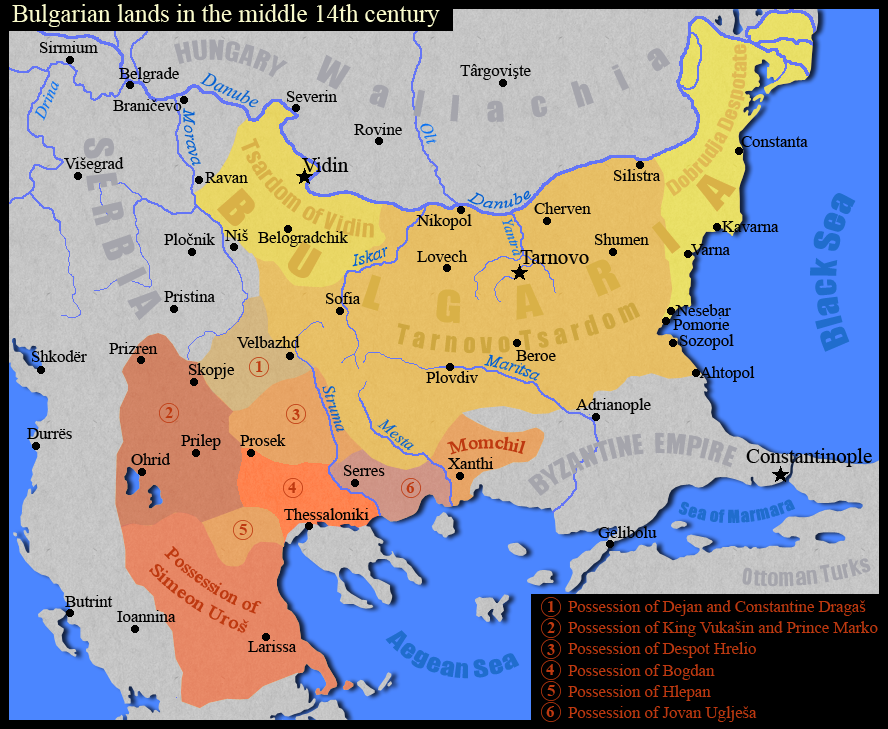
English: Тhe Bulgarian lands in the middle of the 14th century.
Български: Българските земи в средата на 14 век.
Based on map "Феодална разпокъсаност на България и падането и под турска власт (1280-1396)" in the atlas "Атлас История на България за средните училища", "Картография", София, 1990 г., стр. 8 |
| 日期 | |
| 来源 | 自己的作品 |
| 作者 | Kandi |
许可协议
[编辑]
| 我,本作品著作权人,释出本作品至公有领域。这适用于全世界。 在一些国家这可能不合法;如果是这样的话,那么: 我无条件地授予任何人以任何目的使用本作品的权利,除非这些条件是法律规定所必需的。 |

|
File:Bulgarian lands 1350 vek.svg是此文件的矢量版本。 如果此文件质量不低于原点阵图,就应该将这个PNG格式文件替换为此文件。
File:BG 14 vek.png → File:Bulgarian lands 1350 vek.svg
更多信息请参阅Help:SVG/zh。 |
 |
文件历史
点击某个日期/时间查看对应时刻的文件。
| 日期/时间 | 缩略图 | 大小 | 用户 | 备注 | |
|---|---|---|---|---|---|
| 当前 | 2011年9月2日 (五) 17:11 | | 888 × 729(491 KB) | Kandi(留言 | 贡献) | true map |
| 2011年9月2日 (五) 16:24 |  | 730 × 599(571 KB) | Spiridon Ion Cepleanu(留言 | 贡献) | Names, scales and states since Codex Parisinus latinus and genovese maritime maps and descriptions in : Ph. Lauer, Catalogue des manuscrits latins, pp.95-6, d'après la Bibliothèque Nationale Lat. 1623, IX-X, Paris, 1940. And Wallachia are also a heir st | |
| 2009年1月24日 (六) 08:49 |  | 888 × 729(442 KB) | Kandi(留言 | 贡献) | {{Information |Description=Тhe Bulgarian lands in the middle of the 14th century |Source=self-made |Date=24.01.2009 |Author=Kandi |Permission= |other_versions= }} Category:Maps of the history of Bulgaria Category:Maps showing 14th-century history |
您不可以覆盖此文件。
文件用途
全域文件用途
以下其他wiki使用此文件:
- als.wikipedia.org上的用途
- bg.wikipedia.org上的用途
- en.wikipedia.org上的用途
- nl.wikipedia.org上的用途
- pl.wikipedia.org上的用途
- ru.wikipedia.org上的用途
- sr.wikipedia.org上的用途
- uk.wikipedia.org上的用途
- zh.wikipedia.org上的用途