File:BML Le Lointain partie 2 50 27807 planche 2.jpg

Original file (3,775 × 2,726 pixels, file size: 9.58 MB, MIME type: image/jpeg)
Captions
Captions
Summary
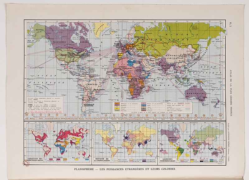
[edit]| Onésime Reclus: Planisphère – Les puissances étrangères et leurs colonies
( |
|||||||||||||||||||||||||||
|---|---|---|---|---|---|---|---|---|---|---|---|---|---|---|---|---|---|---|---|---|---|---|---|---|---|---|---|
| Artist |
|
||||||||||||||||||||||||||
| Title |
Planisphère – Les puissances étrangères et leurs colonies |
||||||||||||||||||||||||||
| Description |
Français : Au 19e siècle, la révolution industrielle et la croissance démographique sur le continent européen sont à l’origine d’un nouvel élan de l’expansion coloniale. La mappemonde, issue de l’Atlas de la plus grande France illustre la compétition européenne pour la domination du monde. Onésime Reclus, son auteur, est un géographe français et fervent promoteur de l’expansion coloniale française, notamment en Afrique. Il appelle à ériger une Afrique française, unifiée par la diffusion de la langue nationale. Il est notamment connu pour être l’inventeur du mot « francophonie » en 1880. Les empires en cours de constitution à la fin du 19e siècle sont pour lui l’avenir. Il développa cette pensée en matière coloniale dans de nombreux ouvrages tout au long de sa vie. - Bibliothèque municipale de Lyon, mis en ligne sur Numelyo |
||||||||||||||||||||||||||
| Date | 1913-1915 | ||||||||||||||||||||||||||
| Medium | Carte | ||||||||||||||||||||||||||
| Collection |
|
||||||||||||||||||||||||||
| Current location |
Bibliothèque de la Part-Dieu |
||||||||||||||||||||||||||
| Accession number | |||||||||||||||||||||||||||
| Place of creation | Paris | ||||||||||||||||||||||||||
| Source/Photographer |
|
||||||||||||||||||||||||||
| Permission (Reusing this file) |
|
||||||||||||||||||||||||||


Licensing
[edit]
| This file is made available under the Creative Commons CC0 1.0 Universal Public Domain Dedication. | |
| The person who associated a work with this deed has dedicated the work to the public domain by waiving all of their rights to the work worldwide under copyright law, including all related and neighboring rights, to the extent allowed by law. You can copy, modify, distribute and perform the work, even for commercial purposes, all without asking permission.
|
File history
Click on a date/time to view the file as it appeared at that time.
| Date/Time | Thumbnail | Dimensions | User | Comment | |
|---|---|---|---|---|---|
| current | 12:29, 14 May 2024 | | 3,775 × 2,726 (9.58 MB) | Fadekha (talk | contribs) | Uploaded a work by Onesime Reclus from ONESIME RECLUS (1837-1916), Atlas de la plus grande France. Géographique, économique, politique, départementale, coloniale…, Paris : Attinger, 1913-1915, planche 2. with UploadWizard |
You cannot overwrite this file.
File usage on Commons
The following page uses this file: