File:Baghdad etm 2003092 lrg.jpg
跳转到导航
跳转到搜索

本预览的尺寸:444 × 599像素。 其他分辨率:178 × 240像素 | 355 × 480像素 | 889 × 1,200像素。
原始文件 (889 × 1,200像素,文件大小:458 KB,MIME类型:image/jpeg)
说明
说明
添加一行文字以描述该文件所表现的内容
| 描述 |
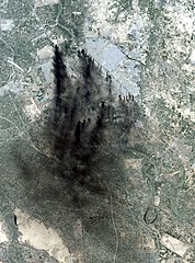
This image shows the city of Baghdad, the capital of Iraq. The dark smoke plumes are from pits of burning oil arrayed in a ring around the center of the city, a tactic used to stall and confuse invaders since medieval times. This picture is computer animated to show how it could look in reality. Baghdad Airport can be seen southwest of the city, just outside the smoke. This image was acquired by Landsat 7's Enhanced Thematic Mapper Plus (ETM+) sensor on April 2, 2003. |
|||||
| 日期 | Image taken on April 2, 2003. | |||||
| 来源 | http://earthobservatory.nasa.gov/NaturalHazards/natural_hazards_v2.php3?img_id=10149 | |||||
| 作者 | Image provided by the USGS EROS Data Center Satellite Systems Branch. | |||||
| 授权 (二次使用本文件) |
|

文件历史
点击某个日期/时间查看对应时刻的文件。
| 日期/时间 | 缩略图 | 大小 | 用户 | 备注 | |
|---|---|---|---|---|---|
| 当前 | 2006年1月9日 (一) 05:58 | | 889 × 1,200(458 KB) | Slarre~commonswiki(留言 | 贡献) | This image shows the city of Baghdad, the capital of Iraq. The dark smoke plumes are from pits of burning oil arrayed in a ring around the center of the city, a tactic used to stall and confuse invaders since medieval times. Baghdad Airport can be seen so |
您不可以覆盖此文件。
文件用途
没有页面使用本文件。
全域文件用途
以下其他wiki使用此文件:
- bg.wikipedia.org上的用途
- ca.wikipedia.org上的用途
- cs.wikipedia.org上的用途
- cy.wikipedia.org上的用途
- da.wikipedia.org上的用途
- de.wikipedia.org上的用途
- en.wikipedia.org上的用途
- en.wikiquote.org上的用途
- es.wikipedia.org上的用途
- fi.wikipedia.org上的用途
- fr.wikipedia.org上的用途
- he.wikipedia.org上的用途
- ko.wikipedia.org上的用途
- no.wikipedia.org上的用途
- pt.wikipedia.org上的用途
- ru.wikipedia.org上的用途
- sv.wikipedia.org上的用途
- tr.wikipedia.org上的用途
- uk.wikipedia.org上的用途
- vi.wikipedia.org上的用途
- zh-classical.wikipedia.org上的用途
- zh.wikipedia.org上的用途