File:Bahnhof Bochum Nord Lohringbruecke Ausfaedelung 2155-EBNO-EBWR 2016-12-17.jpg

Original file (2,200 × 1,676 pixels, file size: 500 KB, MIME type: image/jpeg)
Captions
Captions
Summary
[edit]
| Description |
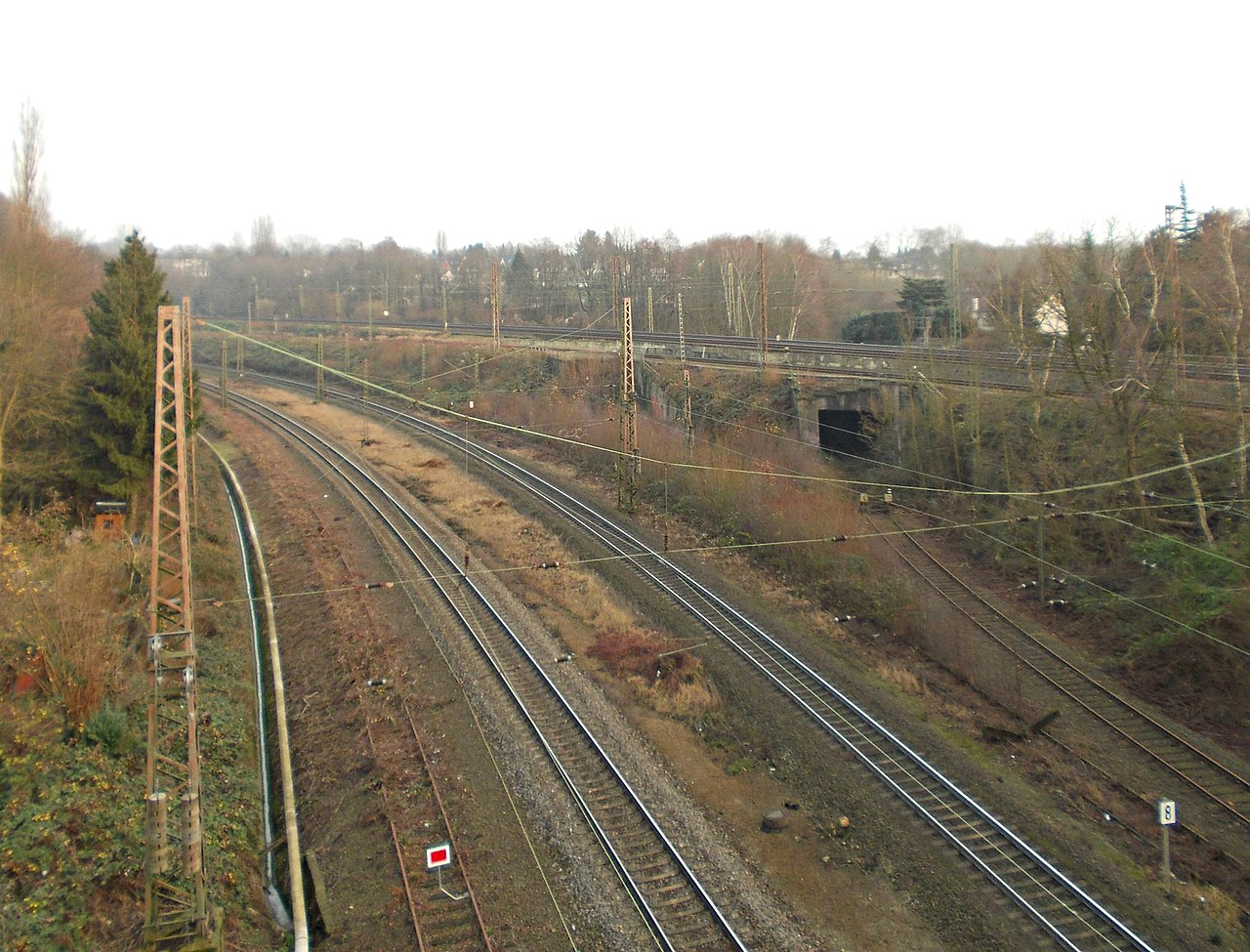
Deutsch: Bahnhof Bochum Nord. Blick von der Lohring-Brücke oberhalb des östlichen Bahnhofskopfs. Links der Bildmitte verlaufen die beiden glänzenden Schienenstränge der Güterbahn DB 2151. Nach rechts zweigt die ehemalige Güterbahn DB 2155 zum ehemaligen Bahnhof Bochum-Weitmar ab.
Auf dem Bahndamm rechts der Bildmitte liegen drei Gleise, dahinter aus dieser Perspektive nicht sichtbar zwei weitere, so dass die Strecke 2155 in Summe fünf Gleise unterquert: Das vorderste Gleis auf dem Damm ist die Strecke DB 2150 vom Abzweig Prinz von Preußen zum Güterbahnhof Bochum. Es kann ab Prinz von Preußen auch für gelegentliche Umleitungen nach Gleis 2 von Bochum Hauptbahnhof verwendet werden, von wo aus Züge weiter auf der Fernbahn, Strecke DB 2160, Richtung Essen fahren können. Die beiden mittleren Gleise auf dem Damm sind die Fernbahn DB 2158 von Bochum Hauptbahnhof nach Dortmund Hauptbahnhof. Die hinteren, hier nicht sichtbaren Gleise gehören zur S-Bahn-Strecke DB 2190. Die Strecke 2155 ist auf fast ganzer Länge in einen Rad- und Gehweg umgebaut worden. Nur die letzten, hier sichtbaren, Meter im Bereich der Überführung und der Einfädelung in den Bahnhof Bochum Nord sind ebenso nicht öffentlich nutzbar wie weitere ca. 150 Meter bis zum Ende des Weges an der Goerdtstraße. Die Reste von zwei weiteren Streckengleisen sind auf beiden Seiten der Strecke 2151 zu sehen. Diese beiden Gleise gingen im Abzweig Prinz von Preußen in die Strecken DB 2156 und DB 2157 über, die rechts und links der Hauptstrecke 2158 als drittes und viertes Gleis bis zum Personenbahnhof Langendreer verliefen. Mit den Umbauten für die S-Bahn und für die Riemker Kurve (Strecke DB 2194) wurden alle Reisezugverkehre vom Bahnhof Bochum Nord auf den Bochumer Hauptbahnhof konzentriert. Die durchgehenden Zugläufe von Langendreer via Bochum Nord nach Herne bzw. Recklinghausen wurden gebrochen. Einerseits wurden sie auf die neue S-Bahn-Strecke von Essen nach Dortmund umgelegt und andererseits die neu eingeführte Riemker Kurve für die Verbindung nach Herne genutzt. Die hier sichtbaren Reste wurden offenkundig als Ausziehgleise von Bochum Nord genutzt. Das nördliche Gleis ist mit einer Schutzhaltscheibe Sh2 gesperrt. Neben dem südlicheren Gleis, das hier mit einem Schwellenkreuz gesperrt und schon länger überwuchert erscheint, führte ein weiteres zu einer zweiten, verschlossenen Öffnung im Bahndamm, deren Rest links der Öffnung für die Strecke nach Weitmar zu sehen ist. Es erreichte so das ehemalige Gütergleis auf der Südseite des Bahndamms, das durch die S-Bahn ersetzt wurde.English: Bochum, Germany. Bochum Nord railway station. View from the Lohring road bridge above the eastern approach to the station. Center left is the active dual-track freight mainline DB 2151 as it leaves the station area. Diverging to the right is former line DB 2155, a single track line to Bochum-Weitmar station disused since 1999.
DB 2155 crosses under a total of five tracks, as there are three tracks atop the embankment and two beyond, out of view. From front to back: The single-track freight line DB 2150, Bochum Prinz von Preussen junction to the Bochum Hauptbahnhof freight yard, also very occasionally used to route main line trains to platform 2 at Bochum central station. The double-track main passenger line DB 2158 between Bochum and Dortmund central stations. Beyond the main line, not visible from this perspective, is the double-track S-Bahn line DB 2190. Line 2155 has been converted to a paved bicycling and foot path throughout, except for the tiny section visible in this picture that ends at point about 150 meters beyond the underpass where the paved path starts. Remnants of former lines, rusted and partly overgrown, are visible to either side of the shiny freight line DB 2151. These two lines fed into the third and fourth track that, starting at Prinz von Preussen junction, ran to either side of DB 2150 to Bochum-Langendreer passenger station. These lines were in use until the late 1970s/early 1980s when all tracks east of Bochum central and north station were reconfigured to accommodate S-Bahn services on DB route 2190. Apparently the leftmost track was used as a tail track of Bochum Nord station after that, given that it is signed as closed by a somewhat new "Sh 2" board (red square with white trim) while the rightmost track is overgrown and blocked by crossed wooden sleepers. |
| Date | |
| Source | Own work |
| Author | Mornsbar |
| Camera location | | View this and other nearby images on: OpenStreetMap |
|---|
Licensing
[edit]
- You are free:
- to share – to copy, distribute and transmit the work
- to remix – to adapt the work
- Under the following conditions:
- attribution – You must give appropriate credit, provide a link to the license, and indicate if changes were made. You may do so in any reasonable manner, but not in any way that suggests the licensor endorses you or your use.
- share alike – If you remix, transform, or build upon the material, you must distribute your contributions under the same or compatible license as the original.
File history
Click on a date/time to view the file as it appeared at that time.
| Date/Time | Thumbnail | Dimensions | User | Comment | |
|---|---|---|---|---|---|
| current | 05:25, 12 February 2022 | | 2,200 × 1,676 (500 KB) | Mornsbar (talk | contribs) | Uploaded own work with UploadWizard |
You cannot overwrite this file.
File usage on Commons
The following page uses this file:
File usage on other wikis
The following other wikis use this file:
- Usage on de.wikipedia.org