File:Balanchine crater in Caloris Basin.jpg
Restren wreydhek (1,312 × 1,000 piksel, myns an restren: 921 KB, eghen MIME: image/jpeg)
Captions
Captions
| Deskrifans |
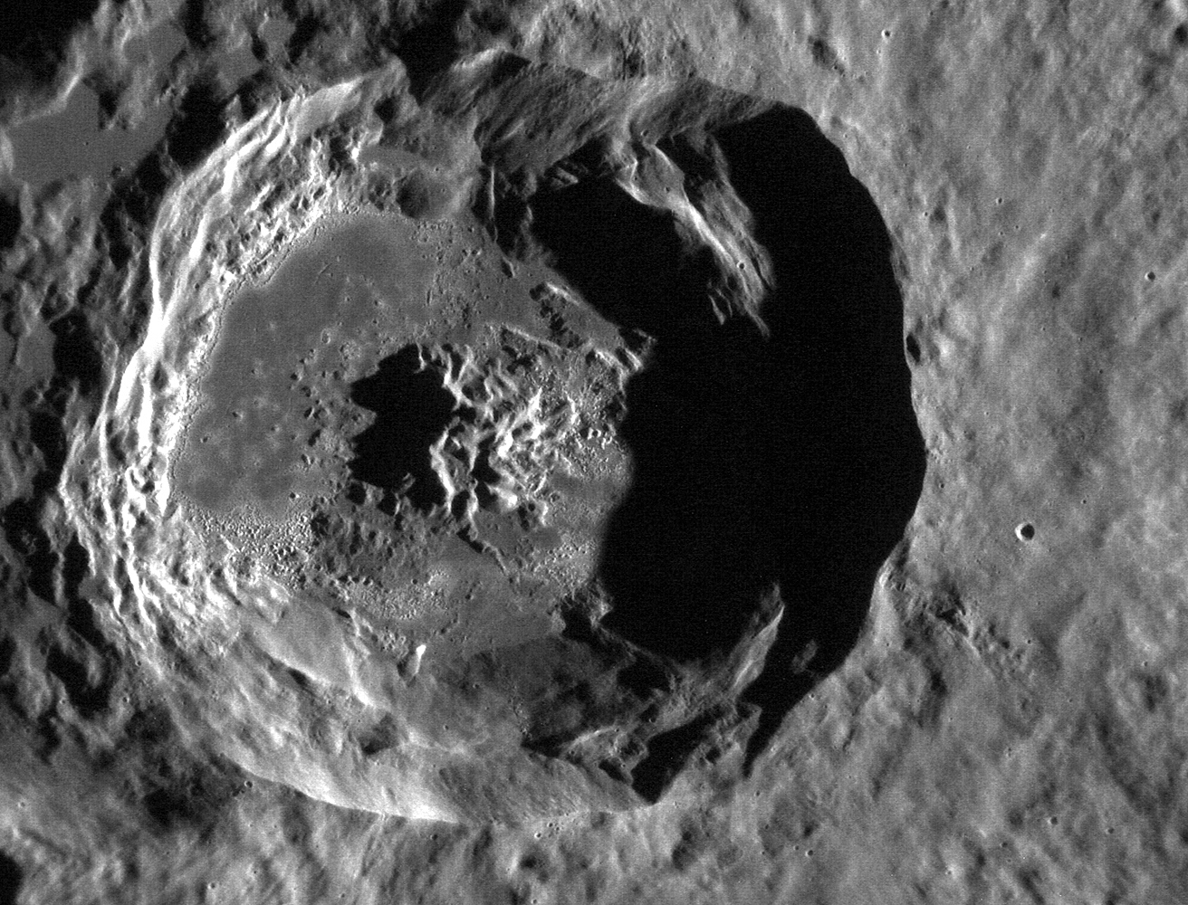
NASA image acquired October 28, 2011 This stunning crater, now called Balanchine, lies within the Caloris basin. Its floor provides another example of the beautiful "hollows" found on Mercury and has an etched appearance similar to that found in the crater Tyagaraja. This image was acquired as a high-resolution targeted observation. Targeted observations are images of a small area on Mercury's surface at resolutions much higher than the 250-meter/pixel (820 feet/pixel) morphology base map or the 1-kilometer/pixel (0.6 miles/pixel) color base map. It is not possible to cover all of Mercury's surface at this high resolution during MESSENGER's one-year mission, but several areas of high scientific interest are generally imaged in this mode each week. The MESSENGER spacecraft is the first ever to orbit the planet Mercury, and the spacecraft's seven scientific instruments and radio science investigation are unraveling the history and evolution of the Solar System's innermost planet. Visit the Why Mercury? section of this website to learn more about the key science questions that the MESSENGER mission is addressing. During the one-year primary mission, MDIS is scheduled to acquire more than 75,000 images in support of MESSENGER's science goals. Credit: NASA/Johns Hopkins University Applied Physics Laboratory/Carnegie Institution of Washington NASA image use policy |
||
| Dedhyans | |||
| Pennfenten | Flickr: MESSENGER View of Mercury's Caloris Basin | ||
| Awtour | NASA Goddard Space Flight Center | ||
| Kummyas (Dastevnydhya an restren ma) |
This file is licensed under the Creative Commons Attribution 2.0 Generic license.
|
| This file is in the public domain in the United States because it was solely created by NASA. NASA copyright policy states that "NASA material is not protected by copyright unless noted". (See Template:PD-USGov, NASA copyright policy page or JPL Image Use Policy.) | ||
 |
Warnings:
|
Istori an restren
Klyckyewgh war dhedhyans/eur rag gweles an folen dell o an termyn na.
| Dedhyans/Eur | Skeusennik | Mynsow | Devnydhyer | Kampol | |
|---|---|---|---|---|---|
| a-lemmyn | 18:01, 27 Genver 2020 | | 1,312 × 1,000 (921 KB) | SteinsplitterBot (keskows | kevrohow) | Bot: Image rotated by 180° |
| 13:03, 30 Ebrel 2018 |  | 1,317 × 1,000 (930 KB) | Nwbeeson (keskows | kevrohow) | Rotated to remove Crater Illusion which made the old image look like a mountain, instead of a hole. | |
| 22:00, 17 Du 2011 |  | 1,317 × 1,000 (879 KB) | Flickr upload bot (keskows | kevrohow) | Uploaded from http://flickr.com/photo/24662369@N07/6323325370 using Flickr upload bot |
Ny yllowgh gorskrifa an restren ma.
Devnydh an restren
Yma an 3 folen a syw owth usya an restren ma:
Devnydh ollvysel an restren
Yma an wikis erel a syw ow tevnydhya an restren ma:
- Devnydh war en.wikipedia.org
- Devnydh war kw.wikipedia.org
- Devnydh war vi.wikipedia.org