File:Balkans-ethnique.JPG

Faylın orijinalı (1.258 × 1.266 piksel, fayl həcmi: 457 KB, MIME növü: image/jpeg)
Captions
Captions

|
This map image could be re-created using vector graphics as an SVG file. This has several advantages; see Commons:Media for cleanup for more information. If an SVG form of this image is available, please upload it and afterwards replace this template with
{{vector version available|new image name}}.
It is recommended to name the SVG file “Balkans-ethnique.svg”—then the template Vector version available (or Vva) does not need the new image name parameter. |


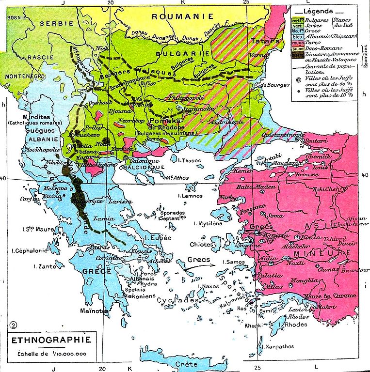
| İzah | Ethnic map of the Balkans. | ||||
| Tarix | |||||
| Mənbə | Histoire Et Géographie - Atlas Général Vidal-Lablache, Librairie Armand Colin, Paris, 1898. | ||||
| Müəllif | Paul Vidal de la Blache | ||||
| İcazə (Faylın təkrar istifadəsi) |
|
||||
| Digər versiyalar |
 |
||||
Faylın tarixçəsi
Faylın əvvəlki versiyasını görmək üçün gün/tarix bölməsindəki tarixlərə klikləyin.
| Tarix/Vaxt | Kiçik şəkil | Ölçülər | İstifadəçi | Şərh | |
|---|---|---|---|---|---|
| indiki | 18:47, 7 noyabr 2009 | | 1.258 × 1.266 (457 KB) | Alex:D (müzakirə | töhfələr) | whitened |
| 07:55, 8 fevral 2007 |  | 1.258 × 1.266 (346 KB) | Olahus (müzakirə | töhfələr) | '''Description:''' Carte ethnique des Balkans '''Source:''' Histoire Et Géographie - Atlas Général Vidal-Lablache, Librairie Armand Colin, Paris, 1898 '''Author:''' Scan made by Olahus '''License:''' Public Domain, because copyright |
Siz bu faylı yenidən yükləyə bilməzsiniz.
Fayl keçidləri
Aşağıdakı 9 səhifə bu faylı istifadə edir:
Faylın qlobal istifadəsi
Bu fayl aşağıdakı vikilərdə istifadə olunur:
- ar.wikipedia.org layihəsində istifadəsi
- azb.wikipedia.org layihəsində istifadəsi
- ba.wikipedia.org layihəsində istifadəsi
- bg.wikipedia.org layihəsində istifadəsi
- cs.wikipedia.org layihəsində istifadəsi
- cv.wikipedia.org layihəsində istifadəsi
- cy.wikipedia.org layihəsində istifadəsi
- da.wikipedia.org layihəsində istifadəsi
- de.wikipedia.org layihəsində istifadəsi
- el.wikipedia.org layihəsində istifadəsi
- en.wikipedia.org layihəsində istifadəsi
- es.wikipedia.org layihəsində istifadəsi
- eu.wikipedia.org layihəsində istifadəsi
- fr.wikipedia.org layihəsində istifadəsi
- gl.wikipedia.org layihəsində istifadəsi
- he.wikipedia.org layihəsində istifadəsi
- it.wikipedia.org layihəsində istifadəsi
- ja.wikipedia.org layihəsində istifadəsi
- jv.wikipedia.org layihəsində istifadəsi
- nn.wikipedia.org layihəsində istifadəsi
- no.wikipedia.org layihəsində istifadəsi
- pl.wikipedia.org layihəsində istifadəsi
Bu faylın qlobal istifadəsinə baxın.
- French-language maps showing history of Europe
- Historical maps of ethnic groups in Albania
- Historical maps of ethnic groups in Bulgaria
- Historical maps of ethnic groups in Greece
- Historical maps of ethnic groups in North Macedonia
- Historical maps of ethnic groups in Romania
- Historical maps of ethnic groups in Serbia
- Historical maps of ethnic groups in Turkey
- Historical maps of ethnic groups in the Balkans
- Maps showing 19th-century history
- Old maps of the Balkans
- Paul Vidal de La Blache