File:Balkhash labeled eng.jpg
跳至導覽
跳至搜尋

預覽大小:800 × 449 像素。 其他解析度:320 × 180 像素 | 640 × 359 像素 | 1,024 × 575 像素 | 1,280 × 719 像素 | 2,036 × 1,143 像素。
原始檔案 (2,036 × 1,143 像素,檔案大小:686 KB,MIME 類型:image/jpeg)
說明
說明
添加單行說明來描述出檔案所代表的內容
| 描述 |
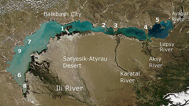
English: Lake Balkhash and the surrounding area viewed from space Русский: Озеро Балхаш и окружающая местность, вид из космоса |
| 日期 | (UTC) |
| 來源 | |
| 作者 |
|
- Saryesik peninsula, separating the lake into two parts, and the Strait Uzynaral
- Baygabyl Peninsula
- Balai Peninsula
- Shaukar Peninsula
- Kentubek Peninsula
- Islands Basaran and Ortaaral
- Tasaral Island
- Shempek Bay
- Saryshagan Bay
| 本作品由NASA創作,屬於公有領域。根據NASA的版權政策:“NASA的創作除非另有聲明否則不受版權保護。”(參見:Template:PD-USGov/zh,NASA版權政策或JPL圖像使用政策) | ||
 |
警告:
|
原始上傳日誌[編輯]
This image is a derivative work of the following images:
- File:Lake_Balkhash_satellite.jpg licensed with PD-USGov-NASA
- 2009-01-26T19:00:08Z Monfornot 3000x2300 (1231868 Bytes) {{Information |Description={{en|1=Lake Balkhash and the surrounding area viewed from space}} {{ru|1=Озеро Балхаш и окружающая местность, вид из космоса}} |Source=http://visibleearth.
Uploaded with derivativeFX
檔案歷史
點選日期/時間以檢視該時間的檔案版本。
| 日期/時間 | 縮圖 | 尺寸 | 用戶 | 備註 | |
|---|---|---|---|---|---|
| 目前 | 2014年5月6日 (二) 05:43 | | 2,036 × 1,143(686 KB) | Materialscientist(對話 | 貢獻) | Relabeled per File:Balkhash labeled ru.jpg |
| 2010年5月24日 (一) 06:42 |  | 2,036 × 1,143(594 KB) | Materialscientist(對話 | 貢獻) | {{Information |Description={{en|1=Lake Balkhash and the surrounding area viewed from space}} {{ru|1=Озеро Балхаш и окружающая местность, вид из космоса}} |Source=*File:Lake_Balkhash_satellite.jpg |Date=2010 |
無法覆蓋此檔案。
檔案用途
沒有使用此檔案的頁面。
全域檔案使用狀況
以下其他 wiki 使用了這個檔案:
- af.wikipedia.org 的使用狀況
- arz.wikipedia.org 的使用狀況
- ast.wikipedia.org 的使用狀況
- bg.wikipedia.org 的使用狀況
- bn.wikipedia.org 的使用狀況
- ca.wikipedia.org 的使用狀況
- de.wikipedia.org 的使用狀況
- de.wikivoyage.org 的使用狀況
- en.wikipedia.org 的使用狀況
- es.wikipedia.org 的使用狀況
- fa.wikipedia.org 的使用狀況
- gl.wikipedia.org 的使用狀況
- he.wikipedia.org 的使用狀況
- hi.wikipedia.org 的使用狀況
- hu.wikipedia.org 的使用狀況
- hy.wikipedia.org 的使用狀況
- id.wikipedia.org 的使用狀況
- it.wikipedia.org 的使用狀況
- ja.wikipedia.org 的使用狀況
- ka.wikipedia.org 的使用狀況
- kn.wikipedia.org 的使用狀況
- lt.wikipedia.org 的使用狀況
- mt.wikipedia.org 的使用狀況
- pnb.wikipedia.org 的使用狀況
- tr.wikipedia.org 的使用狀況
- uk.wikipedia.org 的使用狀況
- uz.wikipedia.org 的使用狀況
- www.wikidata.org 的使用狀況
- zh.wikipedia.org 的使用狀況