File:Baltimore osm-mapnik location map.png
پرش به ناوبری
پرش به جستجو
تفکیکپذیری بالاتری در دسترس نیست.
Baltimore_osm-mapnik_location_map.png (۴۹۰ × ۴۷۵ پیکسل، اندازهٔ پرونده: ۳۴۹ کیلوبایت، نوع MIME پرونده: image/png)
گزینهها
عنوان
شرحی یکخطی از محتوای این فایل اضافه کنید
خلاصه
[ویرایش]
| توضیح |
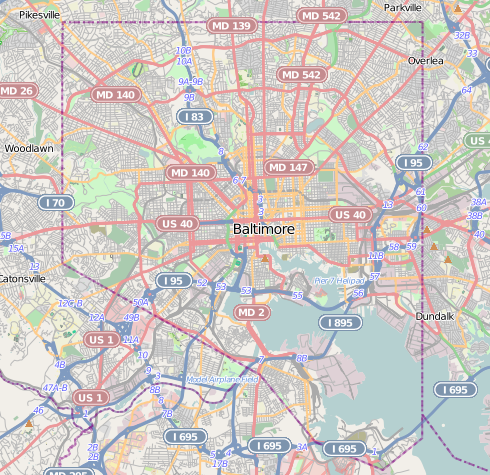
English: Map of Baltimore
Geographic limits of the map:
|
| تاریخ | |
| منبع | http://www.openstreetmap.org |
| پدیدآور | OpenStreetMap contributors |
| اجازهنامه (استفادهٔ مجدد از این پرونده) |
Cartography is licensed as CC-BY-SA (http://www.openstreetmap.org/copyright) |
اجازهنامه
[ویرایش]
| This work contains information from OpenStreetMap, which is made available under the Open Database License (ODbL).
The ODbL does not require any particular license for maps produced from ODbL data. Prior to 1 August 2020, map tiles produced by the OpenStreetMap Foundation were licensed under the CC-BY-SA-2.0 license. Maps produced by other people may be subject to other licences. |
این پرونده با اجازهنامهٔ کریتیو کامانز Attribution-Share Alike 2.0 عمومی منتشر شده است.
- شما اجازه دارید:
- برای به اشتراک گذاشتن – برای کپی، توزیع و انتقال اثر
- تلفیق کردن – برای انطباق اثر
- تحت شرایط زیر:
- انتساب – شما باید اعتبار مربوطه را به دست آورید، پیوندی به مجوز ارائه دهید و نشان دهید که آیا تغییرات ایجاد شدهاند یا خیر. شما ممکن است این کار را به هر روش منطقی انجام دهید، اما نه به هر شیوهای که پیشنهاد میکند که مجوزدهنده از شما یا استفادهتان حمایت کند.
- انتشار مشابه – اگر این اثر را تلفیق یا تبدیل میکنید، یا بر پایه آن اثری دیگر خلق میکنید، میبایست مشارکتهای خود را تحت مجوز یکسان یا مشابه با ا اصل آن توزیع کنید.
تاریخچهٔ پرونده
روی تاریخ/زمانها کلیک کنید تا نسخهٔ مربوط به آن هنگام را ببینید.
| تاریخ/زمان | بندانگشتی | ابعاد | کاربر | توضیح | |
|---|---|---|---|---|---|
| کنونی | ۱۳ دسامبر ۲۰۱۲، ساعت ۲۱:۲۹ | | ۴۹۰ در ۴۷۵ (۳۴۹ کیلوبایت) | Alexrk2 (بحث | مشارکتها) | {{Information |Description={{en|1=Map of Baltimore Geographic limits of the map: * N: 39.3805° * S: 39.1953° * W: -76.7426° * E: -76.4957° }} |Source=http://www.openstreetmap.org |Author=OpenStreetMap contributors |Date=2012-12 |Permission=Cart... |
شما نمیتوانید این پرونده را رونویسی کنید.
کاربرد پرونده
صفحههای زیر از این تصویر استفاده میکنند:
- Baltimore, Maryland
- Category:2020 in Baltimore
- Category:Baltimore
- Category:Baltimore in the 1900s
- Category:Baltimore in the 1910s
- Category:Baltimore in the 1940s
- Category:Baltimore in the 1950s
- Category:Baltimore in the 1960s
- Category:Baltimore in the 1970s
- Category:Baltimore in the 1980s
- Category:Baltimore in the 1990s
- Category:Baltimore in the 2000s
- Category:Baltimore in the 2010s
- Category:Births in Baltimore
- Category:Bridges in Baltimore
- Category:Buildings in Baltimore
- Category:Cemeteries in Baltimore
- Category:Deaths in Baltimore
- Category:Education in Baltimore
- Category:Historic districts in Baltimore, Maryland
- Category:Hotels in Baltimore
- Category:Museums in Baltimore
- Category:National Register of Historic Places in Baltimore, Maryland
- Category:Neighborhoods in Baltimore, Maryland
- Category:Paintings in Baltimore
- Category:Parks in Baltimore
- Category:Politicians of Baltimore
- Category:Politics of Baltimore
- Category:Roads in Baltimore
- Category:Schools in Baltimore
- Category:Sports venues in Baltimore
- Category:Streets in Baltimore
- Category:Tunnels in Baltimore
- Category:Universities and colleges in Baltimore
کاربرد سراسری پرونده
ویکیهای دیگر زیر از این پرونده استفاده میکنند:
- کاربرد در ar.wikipedia.org
- کاربرد در arz.wikipedia.org
- کاربرد در bh.wikipedia.org
- کاربرد در ceb.wikipedia.org
- کاربرد در en.wikipedia.org
- NS Savannah
- Oriole Park at Camden Yards
- M&T Bank Stadium
- SS John W. Brown
- USCGC Taney
- Inner Harbor
- USS Torsk
- United States lightship Chesapeake (LV-116)
- Fell's Point, Baltimore
- Westminster Hall and Burying Ground
- B&O Railroad Museum
- Locust Point, Baltimore
- Federal Hill, Baltimore
- Hampden, Baltimore
- Little Italy, Baltimore
- Congregation Tiferes Yisroel
- Canton, Baltimore
- Bolton Hill, Baltimore
- Phoenix Shot Tower
- Pigtown, Baltimore
- Lyric Baltimore
- Peale Museum
- Armistead Gardens, Baltimore
- Mount Washington, Baltimore
- Curtis Bay, Baltimore
- Abell, Baltimore
- Template:Infobox hospital
- Baltimore Hebrew Congregation
- Reservoir Hill, Baltimore
- Upton, Baltimore
- Butchers Hill, Baltimore
- Washington Hill, Baltimore
- McElderry Park, Baltimore
- Carrollton Viaduct
- Cylburn Arboretum
- Loudon Park National Cemetery
- Jewish Museum of Maryland
- Greektown, Baltimore
- Highlandtown, Baltimore
- Brewers Hill, Baltimore
- Hamilton Hills, Baltimore
- Union Square, Baltimore
- Dickeyville Historic District
نمایش استفادههای سراسری از این پرونده.