File:Banks Penin & Christchurch NZ.jpg
Jump to navigation
Jump to search
No higher resolution available.
Banks_Penin_&_Christchurch_NZ.jpg (720 × 480 pixels, file size: 452 KB, MIME type: image/jpeg)
Captions
Captions
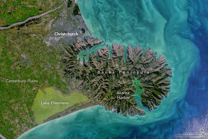
Christchurch & the Banks Peninsula from space, 2021
Summary[edit]
| Description |
.... the relatively flat, low terrain of Canterbury Plains stands out in green. These now-lush plains were built on rocky material from the Southern Alps that was ground up and deposited during glacial periods and then distributed by rivers flowing toward the Pacific Ocean. Today, the plains are covered in a patchwork of agriculture patterns. The image above shows a detailed view of part of the Canterbury Plains near Christchurch, South Island’s largest city. Two of the area’s braided rivers—the Rakia and Waimakariri—cross the plains as they flow from the Southern Alps toward the ocean. The plains extend eastward until reaching Banks Peninsula (Te Pātaka-o-Rākaihautū), at which point the topography changes drastically. Until about 6 million years ago, Banks Peninsula was an active volcanic complex. Since then, water from the sea and from streams have cut away at the rock, helping to shape the peninsula’s valleys, bays, and coastal cliffs. |
|||||
| Date | ||||||
| Source | https://earthobservatory.nasa.gov/images/148852/coastal-color-in-new-zealand?src=eoa-iotd | |||||
| Author | NASA Earth Observatory by Norman Kuring/NASA's Ocean Color Web, using Landsat data from the U.S. Geological Survey. Story by Kathryn Hansen | |||||
| Permission (Reusing this file) |
|

File history
Click on a date/time to view the file as it appeared at that time.
| Date/Time | Thumbnail | Dimensions | User | Comment | |
|---|---|---|---|---|---|
| current | 13:30, 26 September 2021 | | 720 × 480 (452 KB) | Tillman (talk | contribs) | {{Information |Description= .... the relatively flat, low terrain of Canterbury Plains stands out in green. These now-lush plains were built on rocky material from the Southern Alps that was ground up and deposited during glacial periods and then distributed by rivers flowing toward the Pacific Ocean. Today, the plains are covered in a patchwork of agriculture patterns. The image above shows a detailed view of part of the Canterbury Plains near Christchurch, South Island’s largest city. Two o... |
You cannot overwrite this file.
File usage on Commons
There are no pages that use this file.
File usage on other wikis
The following other wikis use this file:
- Usage on en.wikipedia.org
- Usage on tr.wikipedia.org