File:Banqiaomap.png
跳转到导航
跳转到搜索

本预览的尺寸:574 × 599像素。 其他分辨率:230 × 240像素 | 460 × 480像素 | 736 × 768像素 | 1,078 × 1,125像素。
原始文件 (1,078 × 1,125像素,文件大小:82 KB,MIME类型:image/png)
说明
说明
添加一行文字以描述该文件所表现的内容
| 描述 | Banqiao Dam | ||||||||
| 日期 | |||||||||
| 来源 | en.wikipedia | ||||||||
| 作者 | Rolfmueller | ||||||||
| 授权 (二次使用本文件) |
Rolfmueller 位于英语维基百科,本作品著作权人,特此采用以下许可协议发表本作品:
|

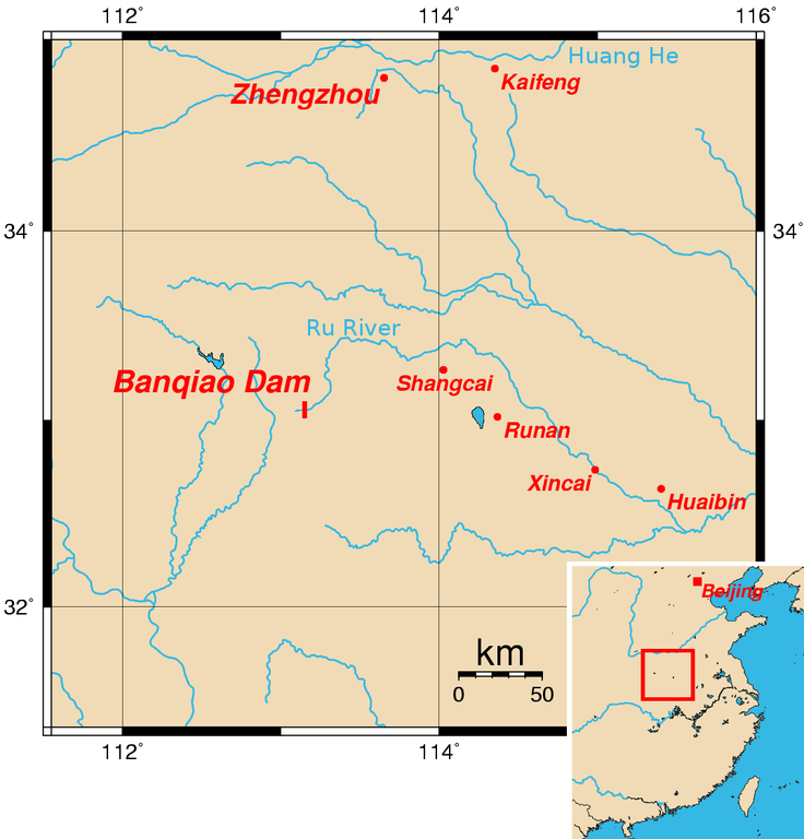
Map of the location of Banqiao Dam. The location of the dam is approximate and assumes that it is close to the village of the same name. The coordinates (longitude, latitude) of the other cities shown on the map are:
- Zhengzhou 113.6500, 34.8000
- Kaifeng 114.3500, 34.8500
- Shangcai 114.0250, 33.2666
- Runan 114.3666, 33.0166
- Xincai 114.9833, 32.7333
- Huaibin 115.4000, 32.6333
This map was created using the Generic Mapping Tools (GMT).
- The location of the dam is accurate — it's right next to the village of the same name. :) -- ran (talk) 06:14, Apr 6, 2005 (UTC)
External Link
[编辑]
文件历史
点击某个日期/时间查看对应时刻的文件。
| 日期/时间 | 缩略图 | 大小 | 用户 | 备注 | |
|---|---|---|---|---|---|
| 当前 | 2008年4月25日 (五) 08:59 | | 1,078 × 1,125(82 KB) | Hellisp(留言 | 贡献) | {{Information |Description=Banqiao Dam |Source=en.wikipedia |Date=25-4-2008 |Author= Rolfmueller |Permission={{GFDL-user-w|en|Wikipedia|Rolfmueller}} |other_versions= }} Map of the location of Banqiao Dam. The location of the dam is approximate and a |
您不可以覆盖此文件。
文件用途
以下2个页面使用本文件:
全域文件用途
以下其他wiki使用此文件:
- arz.wikipedia.org上的用途
- ceb.wikipedia.org上的用途
- cs.wikipedia.org上的用途
- en.wikipedia.org上的用途
- es.wikipedia.org上的用途
- fi.wikipedia.org上的用途
- fr.wikipedia.org上的用途
- it.wikipedia.org上的用途
- ja.wikipedia.org上的用途
- ko.wikipedia.org上的用途
- nl.wikipedia.org上的用途
- no.wikipedia.org上的用途
- pt.wikipedia.org上的用途
- ro.wikipedia.org上的用途
- uk.wikipedia.org上的用途
- www.wikidata.org上的用途
- zh.wikipedia.org上的用途