File:Bardaskan County Map.svg
Jump to navigation
Jump to search

Size of this PNG preview of this SVG file: 788 × 376 pixels. Other resolutions: 320 × 153 pixels | 640 × 305 pixels | 1,024 × 489 pixels | 1,280 × 611 pixels | 2,560 × 1,222 pixels.
Original file (SVG file, nominally 788 × 376 pixels, file size: 21 KB)
Captions
Captions
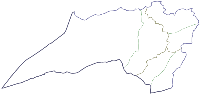
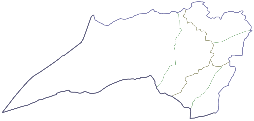
Administrative map of Bardaskan county
Summary
[edit]
| Description |
فارسی: موقعیت بخشها و دهستانهای شهرستان بردسکن تا پایان سال ۱۳۹۹ |
| Date | |
| Source | Own work |
| Author | Mahdy Saffar |
Licensing
[edit]
I, the copyright holder of this work, hereby publish it under the following license:
This file is licensed under the Creative Commons Attribution-Share Alike 4.0 International license.
- You are free:
- to share – to copy, distribute and transmit the work
- to remix – to adapt the work
- Under the following conditions:
- attribution – You must give appropriate credit, provide a link to the license, and indicate if changes were made. You may do so in any reasonable manner, but not in any way that suggests the licensor endorses you or your use.
- share alike – If you remix, transform, or build upon the material, you must distribute your contributions under the same or compatible license as the original.
File history
Click on a date/time to view the file as it appeared at that time.
| Date/Time | Thumbnail | Dimensions | User | Comment | |
|---|---|---|---|---|---|
| current | 13:17, 4 May 2021 | | 788 × 376 (21 KB) | Mahdy Saffar (talk | contribs) | Uploaded own work with UploadWizard |
You cannot overwrite this file.
File usage on Commons
There are no pages that use this file.
File usage on other wikis
The following other wikis use this file:
- Usage on fa.wikipedia.org
- کبودان (بردسکن)
- شفیعآباد (بردسکن)
- خور (بردسکن)
- کلاتهبرق علیا
- اسماعیلآباد (بردسکن)
- درونه (بردسکن)
- صالحیه (بردسکن)
- بالاجو
- چاه مجنگ
- چشمه حاجیسلیمان
- حسینآبادمهلار سفلی
- حسینآبادمهلار علیا
- دهنقلعه
- سرنخواب سفلی
- شلاقه
- سیناب
- علیپلنگ
- کلاته نجف
- باقریه (بردسکن)
- چشمه هادی
- چشمه معدنسیاه
- محمدزورآب
- چشمه نی
- شریفآباد (بردسکن)
- برجک (بردسکن)
- برناباد (بردسکن)
- خنجری (بردسکن)
- علیبیک
- فتحآباد (بردسکن)
- کلاته جمعه
- زمانآباد (بردسکن)
- شریعتآباد (بردسکن)
- یحییآباد (بردسکن)
- حطیطه (بردسکن)
- اسلامآباد (بردسکن)
- مظفرآباد (بردسکن)
- بابالحکم
- مارندیز (بردسکن)
- ابراهیمآباد (بردسکن)
- چشمه چهل
- سیفآباد (بردسکن)
- کلاته نو (بردسکن)
- آبنو (بردسکن)
- علیآباد (بردسکن)
- علیآباد کشمر
- آقمهدی
- کاسف
- هدک
- خمی
- بیجورد
View more global usage of this file.