File:Barentsz arctic map.jpg
ナビゲーションに移動
検索に移動
高解像度版はありません。
Barentsz_arctic_map.jpg (650 × 517 ピクセル、ファイルサイズ: 102キロバイト、MIME タイプ: image/jpeg)
キャプション
キャプション
このファイルの内容を1行で記述してください
概要
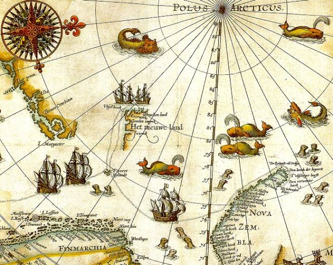
[編集]| 解説 | Portion of 1598 map of Arctic exploration by Willem Barentsz. Spitsbergen, here mapped for the first time, is indicated as "Het Nieuwe Land" (Dutch for "the New Land"), center-left. |
| 日付 | 1598, misdated to 1599 for no stated reason but possibly a 2nd edition or reprint |
| 原典 | Northern Lights Route project at the University Library of Tromsø, from an original print based on Barentsz's charts |
| 作者 | Original charts by Willem Barentsz, drawn by Cornelis Claesz, engraved by Baptista van Doetecum |
| 許可 (ファイルの再利用) |
Public domain (over 70 years since creator's death) |
| その他のバージョン |
|
.jpg)


_door_Willem_Barendsz_(titel_op_object),_NG-800.jpg)
ライセンス
[編集]
|
この著作物は、著作権の保護期間が著作者の死後70年以下である国・地域においてパブリックドメインの状態にあります。 | |
| このファイルは著作権法の既知の制約(隣接権や関連する権利を含む)から自由であると特定されています。 | |
ファイルの履歴
過去の版のファイルを表示するには、その版の日時をクリックしてください。
| 日付と時刻 | サムネイル | 寸法 | 利用者 | コメント | |
|---|---|---|---|---|---|
| 現在の版 | 2006年7月26日 (水) 09:14 | | 650 × 517 (102キロバイト) | TheGrappler (トーク | 投稿記録) | {{Information |Description=Portion of 1599 map of Arctic exploration by Willem Barentsz. Spitsbergen, here mapped for the first time, is indicated as "Het Nieuwe Land" (Dutch for "the New Land"), center-left. |Source=[http://www.ub.uit.no/northernlights/e |
このファイルは上書きできません。
ファイルの使用状況
以下の 10 ページがこのファイルを使用しています:
- Arctic
- Atlas of Svalbard
- File:1598 map of the Polar Regions by Willem Barentsz.jpg
- File:Barents third voyage.jpg
- File:Barentskartet, 1598 (12068020364).jpg
- File:Barentsz Full Map.jpg
- File:Forminsket utgave av Barentskartet - no-nb krt 00487.jpg
- File:Kaart van de landen rond de poolcirkel met de drie reizen van de Nederlanders, 1598 Beschrijvinghe van de drie seylagien door de Hollanders gedaen ande Noordt syde van Noorweghen, Moscovia, nova Sembla, ende door het de, RP-P-OB-80.320.jpg
- File:Kaart van het Noordpoolgebied, 1598 Beschrijvinghe van de drie seylagien door de Hollanders gedaan (..) door Willem Barendsz (titel op object), NG-800.jpg
- File:Pontanus 1611 Arctic Map.jpg
グローバルなファイル使用状況
以下に挙げる他のウィキがこの画像を使っています:
- arz.wikipedia.org での使用状況
- ast.wikipedia.org での使用状況
- ca.wikipedia.org での使用状況
- de.wikipedia.org での使用状況
- el.wikipedia.org での使用状況
- en.wikipedia.org での使用状況
- es.wikipedia.org での使用状況
- fa.wikipedia.org での使用状況
- fr.wikipedia.org での使用状況
- id.wikipedia.org での使用状況
- it.wikipedia.org での使用状況
- ja.wikipedia.org での使用状況
- la.wikipedia.org での使用状況
- no.wikipedia.org での使用状況
- ru.wikipedia.org での使用状況
- uk.wikipedia.org での使用状況
メタデータ
カテゴリ:
- Old maps of Spitsbergen
- Old maps of the Arctic
- Old maps of Svalbard
- Third voyage of Willem Barentsz
- 16th-century maps of the Arctic
- 1598 maps
- Latin-language maps
- Dutch-language maps
- Maps of Novaya Zemlya
- Seals in art
- Whales on maps
- Ships on maps
- Monsters on maps
- Compass roses on maps
- Baptista van Doetecum
- Maps of the North Pole
- Cornelis Claesz
- Reindeer sleds in art
- 16th-century maps of Europe