File:Barking and Dagenham UK locator map.svg
Siirry navigaatioon
Siirry hakuun

Tämän PNG-esikatselun koko koskien SVG-tiedostoa: 750 × 600 kuvapistettä. Muut resoluutiot: 300 × 240 kuvapistettä | 600 × 480 kuvapistettä | 960 × 768 kuvapistettä | 1 280 × 1 024 kuvapistettä | 2 560 × 2 048 kuvapistettä | 1 425 × 1 140 kuvapistettä.
Alkuperäinen tiedosto (SVG-tiedosto; oletustarkkuus 1 425 × 1 140 kuvapistettä; tiedostokoko 1,06 MiB)
Kuvatekstit
Kuvatekstit
Lisää yhden rivin pituinen kuvaus tästä tiedostosta
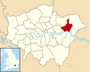
| Kuvaus | Map of Greater London, with Barking and Dagenham highlighted. |
| Päiväys | (UTC) |
| Lähde | |
| Tekijä |
|
.svg)
Minä, tämän teoksen tekijänoikeuksien haltija, julkaisen täten tämän teoksen seuraavalla lisenssillä:
Tämä tiedosto on lisensoitu Creative Commons Nimeä-JaaSamoin 3.0 Ei sovitettu -lisenssillä.
- Voit:
- jakaa – kopioida, levittää ja esittää teosta
- remiksata – valmistaa muutettuja teoksia
- Seuraavilla ehdoilla:
- nimeäminen – Sinun on mainittava lähde asianmukaisesti, tarjottava linkki lisenssiin sekä merkittävä, mikäli olet tehnyt muutoksia. Voit tehdä yllä olevan millä tahansa kohtuullisella tavalla, mutta et siten, että annat ymmärtää lisenssinantajan suosittelevan sinua tai teoksen käyttöäsi.
- jaa samoin – Jos muutat tai perustat tähän työhön, voit jakaa tuloksena syntyvää työtä vain tällä tai tämän kaltaisella lisenssillä.
Alkuperäinen tallennusloki[muokkaa]
This image is a derivative work of the following images:
- File:Greater_London_UK_district_map_(blank).svg licensed with Cc-by-sa-3.0
- 2010-08-22T08:09:33Z Nilfanion 1425x1140 (1104179 Bytes) +inset, water colour tweak
- 2010-07-16T23:35:33Z Nilfanion 1425x1140 (738807 Bytes) {{Information |Description=Map of [[w:Greater London|Greater London]], UK with districts shown. Equirectangular map projection on WGS 84 datum, with N/S stretched 160% Geographic limits: *West: 0.57W *East: 0.37E *North: 51
Uploaded with derivativeFX
Tiedoston historia
Päiväystä napsauttamalla näet, millainen tiedosto oli kyseisellä hetkellä.
| Päiväys | Pienoiskuva | Koko | Käyttäjä | Kommentti | |
|---|---|---|---|---|---|
| nykyinen | 31. heinäkuuta 2011 kello 18.52 | | 1 425 × 1 140 (1,06 MiB) | Renly~commonswiki (keskustelu | muokkaukset) | {{Information |Description=Map of Greater London, with Barking and Dagenham highlighted. |Source=*File:Greater_London_UK_district_map_(blank).svg |Date=2011-07-31 18:46 (UTC) |Author= |
Et voi tallentaa uutta tiedostoa tämän tilalle.
Tiedoston käyttö
Seuraavat 7 sivua käyttävät tätä tiedostoa:
- Category:Births in the London Borough of Barking and Dagenham
- Category:London Borough of Barking and Dagenham
- Category:People of the London Borough of Barking and Dagenham
- Category:Railway stations in the London Borough of Barking and Dagenham
- Category:Sports in the London Borough of Barking and Dagenham
- Category:Transport in the London Borough of Barking and Dagenham
- Category:Views of the London Borough of Barking and Dagenham
Tiedoston järjestelmänlaajuinen käyttö
Seuraavat muut wikit käyttävät tätä tiedostoa:
- Käyttö kohteessa azb.wikipedia.org
- Käyttö kohteessa az.wikipedia.org
- Käyttö kohteessa ca.wikipedia.org
- Käyttö kohteessa en.wikipedia.org
- Käyttö kohteessa eo.wikipedia.org
- Käyttö kohteessa es.wikipedia.org
- Käyttö kohteessa eu.wikipedia.org
- Käyttö kohteessa fa.wikipedia.org
- Käyttö kohteessa fr.wikipedia.org
- Käyttö kohteessa ga.wikipedia.org
- Käyttö kohteessa ko.wikipedia.org
- Käyttö kohteessa no.wikipedia.org
- Käyttö kohteessa pt.wikipedia.org
- Käyttö kohteessa ro.wikipedia.org
- Käyttö kohteessa sh.wikipedia.org
- Käyttö kohteessa sr.wikipedia.org
- Käyttö kohteessa tg.wikipedia.org
- Käyttö kohteessa uk.wikipedia.org
- Käyttö kohteessa www.wikidata.org
- Käyttö kohteessa zh-min-nan.wikipedia.org