File:Bassin-Dordogne.jpg
Jump to navigation
Jump to search

Size of this preview: 800 × 519 pixels. Other resolutions: 320 × 208 pixels | 640 × 416 pixels | 1,024 × 665 pixels | 1,280 × 831 pixels | 2,560 × 1,662 pixels | 5,457 × 3,543 pixels.
Original file (5,457 × 3,543 pixels, file size: 1.01 MB, MIME type: image/jpeg)
Captions
Captions
Add a one-line explanation of what this file represents
Summary
[edit]
| Description |
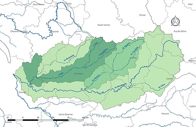
Français : Découpage du bassin versant de la Dordogne en secteurs hydrographiques. |
| Date | |
| Source | Own work |
| Author | Roland45 |
Sources :
- Découpage administratif communal français issu d'OpenStreetMap : Export simple du 11 janvier 2017 sur le site du portail de données libres du gouvernement français
- Cours d'eau Cours d'eau - Métropole 2014 - BD Carthage
- Régions hydrographiques Régions hydrographiques définies dans BD Carthage - Données 2014 diffusées le 13 novembre 2015
Assemblées et enrichies dans QGis
Licensing
[edit]
I, the copyright holder of this work, hereby publish it under the following license:
This file is licensed under the Creative Commons Attribution-Share Alike 4.0 International license.
- You are free:
- to share – to copy, distribute and transmit the work
- to remix – to adapt the work
- Under the following conditions:
- attribution – You must give appropriate credit, provide a link to the license, and indicate if changes were made. You may do so in any reasonable manner, but not in any way that suggests the licensor endorses you or your use.
- share alike – If you remix, transform, or build upon the material, you must distribute your contributions under the same or compatible license as the original.
File history
Click on a date/time to view the file as it appeared at that time.
| Date/Time | Thumbnail | Dimensions | User | Comment | |
|---|---|---|---|---|---|
| current | 16:34, 4 November 2017 | | 5,457 × 3,543 (1.01 MB) | Roland45 (talk | contribs) | =={{int:filedesc}}== {{Information |description={{fr|1=Découpage du bassin versant de la Dordogne en secteurs hydrographiques.}} |date=2017-11-04 |source={{own}} |author=Roland45 |permission= |other versions= }} Sources : * Découpa... |
| 16:19, 4 November 2017 |  | 5,457 × 3,543 (1.01 MB) | Roland45 (talk | contribs) | User created page with UploadWizard |
You cannot overwrite this file.
File usage on Commons
There are no pages that use this file.
File usage on other wikis
The following other wikis use this file:
- Usage on es.wikipedia.org
- Usage on fr.wikipedia.org