File:Batimetriezh ar Mor Keltiek ha Pleg-mor Gwaskogn.svg
From Wikimedia Commons, the free media repository
Jump to navigation
Jump to search

Size of this PNG preview of this SVG file: 548 × 599 pixels. Other resolutions: 219 × 240 pixels | 439 × 480 pixels | 702 × 768 pixels | 936 × 1,024 pixels | 1,872 × 2,048 pixels | 3,478 × 3,804 pixels.
Original file (SVG file, nominally 3,478 × 3,804 pixels, file size: 4.92 MB)
File information
Structured data
Captions
Captions
Add a one-line explanation of what this file represents
Summary[edit]
| DescriptionBatimetriezh ar Mor Keltiek ha Pleg-mor Gwaskogn.svg |
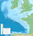
Brezhoneg: Kartenn v-batimetrek e brezhoneg ar Mor Keltiek ha Pleg-mor Gwaskogn. Bevennoù ar morioù hervez an Aozadur hidrografek etrebroadel.
English: Bathymetric map in Breton of the Celtic Sea and the Bay of Biscay. Limits of the seas as specified by the International Hydrographic Organization.
Français : Carte bathymétrique en breton de la Mer Celtique et du Golfe de Gascogne. Limites des mers telles que définies par l'Organisation Hydrographique Internationale. |
| Date | |
| Source |
|
| Author |
|
| Other versions |
[edit]
|
Licensing[edit]
This file is licensed under the Creative Commons Attribution-Share Alike 3.0 Unported license.
- You are free:
- to share – to copy, distribute and transmit the work
- to remix – to adapt the work
- Under the following conditions:
- attribution – You must give appropriate credit, provide a link to the license, and indicate if changes were made. You may do so in any reasonable manner, but not in any way that suggests the licensor endorses you or your use.
- share alike – If you remix, transform, or build upon the material, you must distribute your contributions under the same or compatible license as the original.
File history
Click on a date/time to view the file as it appeared at that time.
| Date/Time | Thumbnail | Dimensions | User | Comment | |
|---|---|---|---|---|---|
| current | 12:06, 12 February 2024 |  | 3,478 × 3,804 (4.92 MB) | Adriendelucca (talk | contribs) | reizhadennoù / corrections |
| 03:08, 12 February 2024 |  | 3,478 × 3,804 (4.92 MB) | Adriendelucca (talk | contribs) | anvioù reizhet | |
| 14:05, 29 October 2023 |  | 3,478 × 3,804 (4.92 MB) | Adriendelucca (talk | contribs) | Uploaded a work by *Original Celtic Sea and Bay of Biscay bathymetric map-fr.svg by Eric Gaba ({{U|Sting}} - {{Wf|Utilisateur:Sting|fr:Sting}}) *Bet troet e brezhoneg gant {{U|Adriendelucca}} from *Breton translation of Celtic Sea and Bay of Biscay bathymetric map-fr.svg *Sources used:<br/> **GEBCO_2019 Grid (public domain)<br/> **NGDC GSHHS (public domain)<br/> **EEA EC... |
You cannot overwrite this file.
File usage on Commons
The following 9 pages use this file:
- User:Adriendelucca
- User:Magog the Ogre/Multilingual legend/2023 October 27-31
- User:Magog the Ogre/Multilingual legend/2024 February 10-14
- File:Batimetriezh ar Mor Keltiek ha Pleg-mor Gwaskogn.svg
- File:Celtic Sea and Bay of Biscay bathymetric map-en.svg
- File:Celtic Sea and Bay of Biscay bathymetric map-es.svg
- File:Celtic Sea and Bay of Biscay bathymetric map-fr.svg
- File:Celtic Sea and Bay of Biscay bathymetric map-mk.svg
- Template:Other versions/Celtic Sea and Bay of Biscay bathymetric map
File usage on other wikis
The following other wikis use this file:
- Usage on br.wikipedia.org
Metadata
This file contains additional information such as Exif metadata which may have been added by the digital camera, scanner, or software program used to create or digitize it. If the file has been modified from its original state, some details such as the timestamp may not fully reflect those of the original file. The timestamp is only as accurate as the clock in the camera, and it may be completely wrong.
| Short title | Bathymetric map of the Celtic Sea and the Bay of Biscay |
|---|---|
| Width | 3478 |
| Height | 3804 |
Structured data
Items portrayed in this file
depicts
29 October 2023
image/svg+xml
bca06299d93aa047afba6517c4952598ded0349f
5,162,766 byte
3,804 pixel
3,478 pixel
Hidden category:


